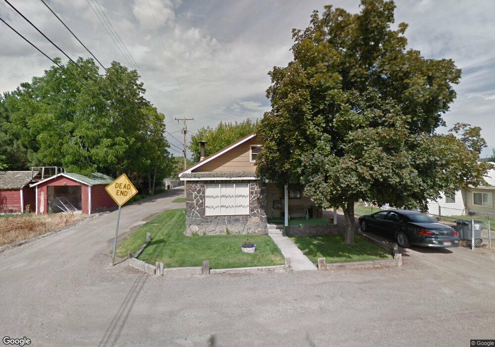
229 Pine St Kimberly, ID 83341
Estimated Value: $201,000 - $240,000
2
Beds
1
Bath
798
Sq Ft
$271/Sq Ft
Est. Value
About This Home
This home is located at 229 Pine St, Kimberly, ID 83341 and is currently estimated at $216,042, approximately $270 per square foot. 229 Pine St is a home with nearby schools including Kimberly Elementary School, STRICKER ELEMENTARY SCHOOL, and Kimberly Middle School.
Ownership History
Date
Name
Owned For
Owner Type
Purchase Details
Closed on
Aug 1, 2013
Sold by
The Estates Of W D Jacobs And Hattie Jac and Jacobs Wilber D
Bought by
Okarma Duane A and Okarma Donna M
Current Estimated Value
Home Financials for this Owner
Home Financials are based on the most recent Mortgage that was taken out on this home.
Original Mortgage
$51,701
Outstanding Balance
$37,594
Interest Rate
3.92%
Mortgage Type
New Conventional
Estimated Equity
$178,448
Create a Home Valuation Report for This Property
The Home Valuation Report is an in-depth analysis detailing your home's value as well as a comparison with similar homes in the area
Home Values in the Area
Average Home Value in this Area
Purchase History
| Date | Buyer | Sale Price | Title Company |
|---|---|---|---|
| Okarma Duane A | -- | Titlefact Inc |
Source: Public Records
Mortgage History
| Date | Status | Borrower | Loan Amount |
|---|---|---|---|
| Open | Okarma Duane A | $51,701 |
Source: Public Records
Tax History
| Year | Tax Paid | Tax Assessment Tax Assessment Total Assessment is a certain percentage of the fair market value that is determined by local assessors to be the total taxable value of land and additions on the property. | Land | Improvement |
|---|---|---|---|---|
| 2025 | $795 | $165,846 | $53,106 | $112,740 |
| 2024 | $776 | $165,846 | $53,106 | $112,740 |
| 2023 | $738 | $170,606 | $53,106 | $117,500 |
| 2022 | $928 | $152,195 | $34,695 | $117,500 |
| 2021 | $960 | $114,953 | $18,873 | $96,080 |
| 2020 | $714 | $84,093 | $18,873 | $65,220 |
| 2019 | $761 | $82,893 | $18,873 | $64,020 |
| 2018 | $725 | $75,813 | $11,533 | $64,280 |
| 2017 | $662 | $67,273 | $11,533 | $55,740 |
| 2016 | $544 | $53,163 | $0 | $0 |
| 2015 | $547 | $53,163 | $11,533 | $41,630 |
| 2012 | -- | $55,900 | $0 | $0 |
Source: Public Records
Map
Nearby Homes
- 715 Center St W
- 219 Madison St W
- 4028 3500 E
- 152 U S 30
- 530 Madeleine Way Unit Homesite 219
- 330 Birch St S
- 336 Maxine Ln W
- 322 Maxine Ln W Unit Homesite 210
- 322 Maxine Ln W
- 306 Maxine Ln W
- 306 Maxine Ln W Unit Homesite 209
- 258 Maxine Ln W
- 258 Maxine Ln W Unit Homesite 207
- 687 Will Ln
- 178 Maxine Ln W Unit homesite 204
- 160 Maxine Ln W Unit Homesite 203
- 160 Maxine Ln W
- 4022 N 3536 E
- 890 Adamite Rd
- 4035 N 3510 E
Your Personal Tour Guide
Ask me questions while you tour the home.