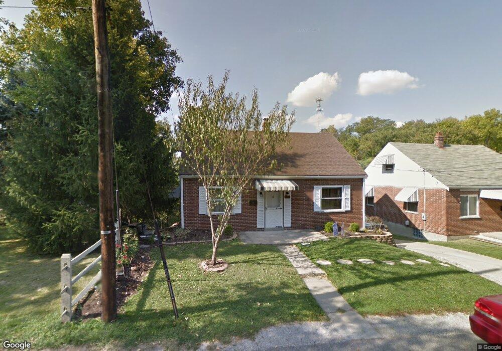
229 Poplar St Newport, KY 41071
Estimated Value: $205,644 - $242,000
--
Bed
1
Bath
1,626
Sq Ft
$141/Sq Ft
Est. Value
About This Home
This home is located at 229 Poplar St, Newport, KY 41071 and is currently estimated at $228,661, approximately $140 per square foot. 229 Poplar St is a home located in Campbell County with nearby schools including Newport Primary School, Newport Intermediate School, and Newport High School.
Ownership History
Date
Name
Owned For
Owner Type
Purchase Details
Closed on
Dec 9, 1996
Sold by
Wiseman Gerald S
Bought by
Reynolds Mark D and Reynolds Brenda L
Current Estimated Value
Home Financials for this Owner
Home Financials are based on the most recent Mortgage that was taken out on this home.
Original Mortgage
$63,000
Outstanding Balance
$6,479
Interest Rate
7.83%
Mortgage Type
New Conventional
Estimated Equity
$222,182
Create a Home Valuation Report for This Property
The Home Valuation Report is an in-depth analysis detailing your home's value as well as a comparison with similar homes in the area
Home Values in the Area
Average Home Value in this Area
Purchase History
| Date | Buyer | Sale Price | Title Company |
|---|---|---|---|
| Reynolds Mark D | $80,000 | -- |
Source: Public Records
Mortgage History
| Date | Status | Borrower | Loan Amount |
|---|---|---|---|
| Open | Reynolds Mark D | $63,000 |
Source: Public Records
Tax History Compared to Growth
Tax History
| Year | Tax Paid | Tax Assessment Tax Assessment Total Assessment is a certain percentage of the fair market value that is determined by local assessors to be the total taxable value of land and additions on the property. | Land | Improvement |
|---|---|---|---|---|
| 2024 | $399 | $150,000 | $20,000 | $130,000 |
| 2023 | $287 | $119,100 | $7,900 | $111,200 |
| 2022 | $382 | $119,100 | $7,900 | $111,200 |
| 2021 | $557 | $119,100 | $7,900 | $111,200 |
| 2020 | $567 | $119,100 | $7,900 | $111,200 |
| 2019 | $548 | $113,500 | $7,900 | $105,600 |
| 2018 | $540 | $113,500 | $7,900 | $105,600 |
| 2017 | $543 | $113,500 | $7,900 | $105,600 |
| 2016 | $512 | $113,500 | $0 | $0 |
| 2015 | $520 | $113,500 | $0 | $0 |
| 2014 | $510 | $113,500 | $0 | $0 |
Source: Public Records
Map
Nearby Homes
- 252 Linden Ave
- 8 Laycock Ln
- 2220 New Linden Rd
- 2115 Monmouth St
- 118 Electric Ave
- 15 Custis Ave
- 100 Mayo Cir
- 10 Washington Ave
- 249 Bluegrass Ave
- 43.5-45.5, Kentucky Dr
- 85 & 87 Kentucky Dr
- 739 Highland Ave
- 39 19th St
- 304 Newman Ave
- 3008 Nob Hill Dr
- 8012 Nob Hill Dr
- 22 Carriage House Dr
- 94 Home St
- 12 Amelia St
- 22 Greenwood Ave