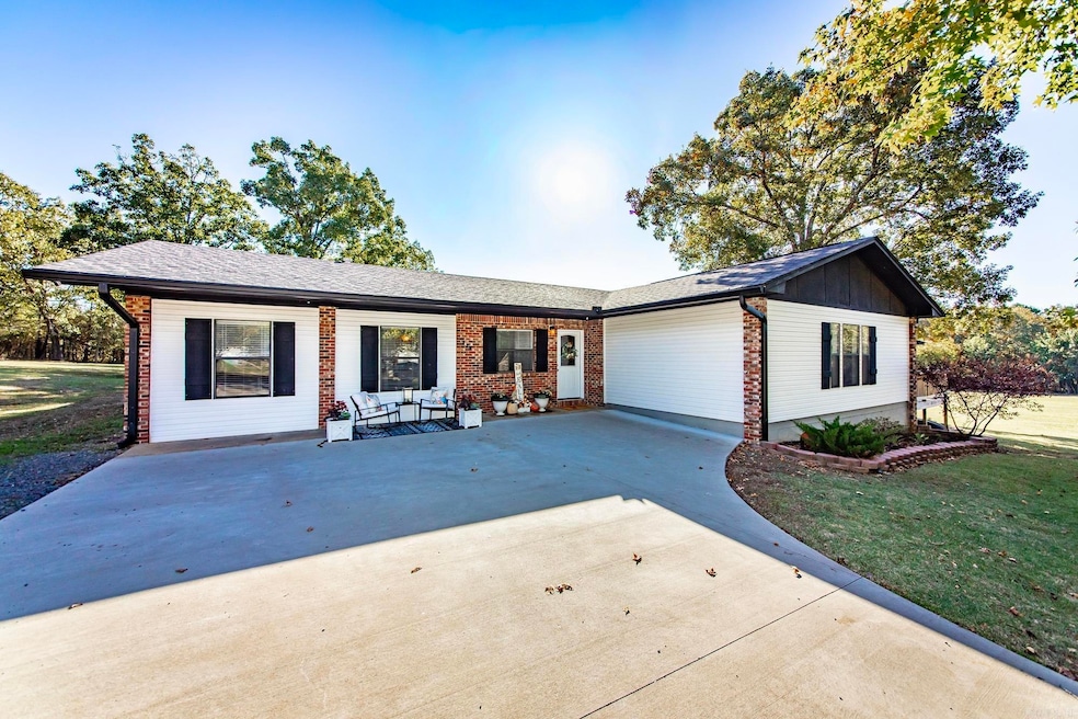


229 Richard St Clinton, AR 72031
Estimated payment $2,208/month
Highlights
- Sitting Area In Primary Bedroom
- River Nearby
- Wooded Lot
- 3.65 Acre Lot
- Deck
- Traditional Architecture
About This Home
Welcome home to peace and plenty of space! This inviting 4-bedroom, 2-bath home sits on 3.65 beautiful acres at the end of a quiet dead-end road. Remodeled in 2016, it offers an open floor plan with a large family room perfect for gathering & making memories. The spacious primary suite includes a cozy gas fireplace, walk-in shower, & his-and-her walk-in closets—an ideal retreat at the end of the day. Step outside to a huge yard made for kids, pets, gardening & outdoor fun, or relax on the large deck that’s perfect for grilling, entertaining, or simply enjoying the peaceful surroundings. There is a 12x16 shop/storage building with electricity perfect for hobbies. Located just 6 miles from Choctaw Campground/Marina on stunning Greers Ferry Lake & half a mile to Walmart and Ozark Health hospital, this home brings together quiet country living, close proximity to city amenities & easy access to the water.
Home Details
Home Type
- Single Family
Est. Annual Taxes
- $1,253
Year Built
- Built in 1978
Lot Details
- 3.65 Acre Lot
- Partially Fenced Property
- Landscaped
- Level Lot
- Cleared Lot
- Wooded Lot
Parking
- Parking Pad
Home Design
- Traditional Architecture
- Brick Frame
- Architectural Shingle Roof
Interior Spaces
- 2,492 Sq Ft Home
- 1-Story Property
- Wired For Data
- Sheet Rock Walls or Ceilings
- Ceiling Fan
- Gas Log Fireplace
- Insulated Windows
- Insulated Doors
- Great Room
- Formal Dining Room
- Open Floorplan
- Home Office
- Crawl Space
- Fire and Smoke Detector
Kitchen
- Eat-In Kitchen
- Gas Range
- Microwave
- Dishwasher
- Granite Countertops
Flooring
- Wood
- Carpet
- Concrete
- Tile
Bedrooms and Bathrooms
- 4 Bedrooms
- Sitting Area In Primary Bedroom
- Walk-In Closet
- 2 Full Bathrooms
- Walk-in Shower
Laundry
- Laundry Room
- Washer and Electric Dryer Hookup
Outdoor Features
- River Nearby
- Deck
- Outdoor Storage
- Shop
- Porch
Schools
- Clinton Elementary And Middle School
- Clinton High School
Utilities
- Central Heating and Cooling System
- Programmable Thermostat
- Co-Op Electric
- Gas Water Heater
Community Details
- Video Patrol
Map
Home Values in the Area
Average Home Value in this Area
Tax History
| Year | Tax Paid | Tax Assessment Tax Assessment Total Assessment is a certain percentage of the fair market value that is determined by local assessors to be the total taxable value of land and additions on the property. | Land | Improvement |
|---|---|---|---|---|
| 2025 | $1,253 | $43,720 | $4,380 | $39,340 |
| 2024 | $623 | $23,900 | $4,380 | $19,520 |
| 2023 | $698 | $23,900 | $4,380 | $19,520 |
| 2022 | $1,123 | $23,900 | $4,380 | $19,520 |
| 2021 | $1,123 | $23,900 | $4,380 | $19,520 |
| 2020 | $748 | $23,900 | $4,380 | $19,520 |
| 2019 | $775 | $24,460 | $4,380 | $20,080 |
| 2018 | $800 | $24,460 | $4,380 | $20,080 |
| 2017 | $1,145 | $24,460 | $4,380 | $20,080 |
| 2015 | -- | $18,570 | $4,390 | $14,180 |
| 2014 | -- | $18,570 | $4,390 | $14,180 |
| 2013 | -- | $18,570 | $4,390 | $14,180 |
Property History
| Date | Event | Price | List to Sale | Price per Sq Ft |
|---|---|---|---|---|
| 10/22/2025 10/22/25 | For Sale | $399,999 | -- | $161 / Sq Ft |
Purchase History
| Date | Type | Sale Price | Title Company |
|---|---|---|---|
| Interfamily Deed Transfer | -- | None Available | |
| Warranty Deed | $78,000 | None Available | |
| Warranty Deed | $68,000 | -- | |
| Warranty Deed | $60,000 | -- | |
| Warranty Deed | $55,000 | -- |
Mortgage History
| Date | Status | Loan Amount | Loan Type |
|---|---|---|---|
| Open | $172,000 | New Conventional | |
| Closed | $81,980 | Credit Line Revolving |
Source: Cooperative Arkansas REALTORS® MLS
MLS Number: 25042349
APN: 1976-00094-0000
Disclaimer: Certain information contained herein is derived from information provided by parties other than Homes.com. All information provided is deemed reliable, but is not guaranteed to be accurate and should be independently verified.
![]() IDX information is provided exclusively for personal, non-commercial use, and may not be used for any purpose other than to identify prospective properties consumers may be interested in purchasing.
IDX information is provided exclusively for personal, non-commercial use, and may not be used for any purpose other than to identify prospective properties consumers may be interested in purchasing.
- 0 Highway 65 S Unit 20037632
- 0000 Highway 65 S
- 240 Huie St
- 2304 Highway 65 S
- 2153 S 65 Hwy
- 936 Cemetery Rd
- Lots 9 &10 Kip Ln
- Clinton Kip Ln
- Clinton Kip Ln
- 000 Donnies Dr
- 799 Barrens Community Rd
- TBD Highway 65
- 715 Jason St
- 1174 Highway 65 S
- 000 Ar 336 Hwy W
- 4971 Highway 65
- 2 acres Highway 65
- 4263 Highway 65 S
- 155 Edwards St
- TBD Adrianne Ave

Ask me questions while you tour the home.