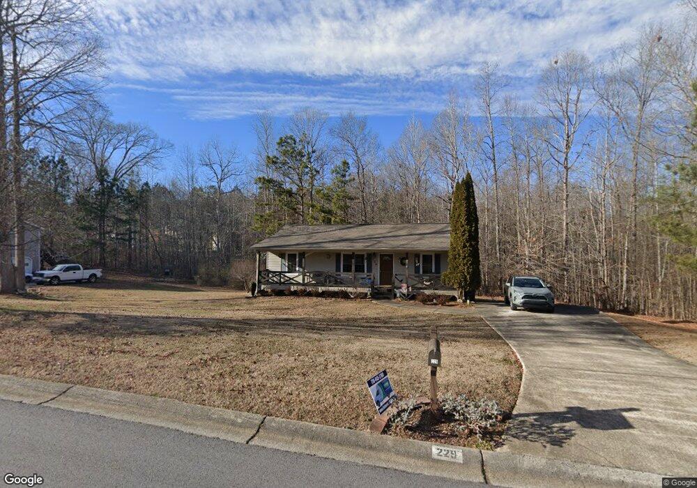
229 Rustin Dr Dallas, GA 30157
Estimated Value: $242,035 - $261,000
3
Beds
3
Baths
1,118
Sq Ft
$226/Sq Ft
Est. Value
About This Home
This home is located at 229 Rustin Dr, Dallas, GA 30157 and is currently estimated at $252,509, approximately $225 per square foot. 229 Rustin Dr is a home located in Paulding County with nearby schools including Union Elementary School, Carl Scoggins Sr. Middle School, and South Paulding High School.
Ownership History
Date
Name
Owned For
Owner Type
Purchase Details
Closed on
May 15, 2019
Sold by
Hughes Virginia L
Bought by
Hughes Virginia L and Marbut Misty Leeann
Current Estimated Value
Purchase Details
Closed on
Mar 27, 2006
Sold by
Chase Hm Fin Llc
Bought by
Hughes Virginia L
Home Financials for this Owner
Home Financials are based on the most recent Mortgage that was taken out on this home.
Original Mortgage
$89,750
Interest Rate
6.23%
Mortgage Type
New Conventional
Purchase Details
Closed on
Jan 3, 2006
Sold by
Brewer Gary C and Brewer Annette L
Bought by
Chase Hm Fin Llc
Create a Home Valuation Report for This Property
The Home Valuation Report is an in-depth analysis detailing your home's value as well as a comparison with similar homes in the area
Home Values in the Area
Average Home Value in this Area
Purchase History
| Date | Buyer | Sale Price | Title Company |
|---|---|---|---|
| Hughes Virginia L | -- | -- | |
| Hughes Virginia L | $88,000 | -- | |
| Chase Hm Fin Llc | $74,800 | -- |
Source: Public Records
Mortgage History
| Date | Status | Borrower | Loan Amount |
|---|---|---|---|
| Previous Owner | Hughes Virginia L | $89,750 |
Source: Public Records
Tax History Compared to Growth
Tax History
| Year | Tax Paid | Tax Assessment Tax Assessment Total Assessment is a certain percentage of the fair market value that is determined by local assessors to be the total taxable value of land and additions on the property. | Land | Improvement |
|---|---|---|---|---|
| 2024 | $624 | $95,208 | $12,000 | $83,208 |
| 2023 | $700 | $90,132 | $12,000 | $78,132 |
| 2022 | $627 | $79,332 | $12,000 | $67,332 |
| 2021 | $581 | $60,384 | $8,000 | $52,384 |
| 2020 | $548 | $54,076 | $8,000 | $46,076 |
| 2019 | $521 | $49,764 | $8,000 | $41,764 |
| 2018 | $425 | $41,780 | $8,000 | $33,780 |
| 2017 | $375 | $36,148 | $6,000 | $30,148 |
| 2016 | $908 | $31,908 | $6,000 | $25,908 |
| 2015 | $814 | $28,304 | $6,000 | $22,304 |
| 2014 | $476 | $16,940 | $6,000 | $10,940 |
| 2013 | -- | $13,960 | $6,000 | $7,960 |
Source: Public Records
Map
Nearby Homes
- 177 Rustin Dr
- 0 Rustin Dr Unit 10617842
- 0 Rustin Dr Unit 7657021
- 128 Tanner Dr
- 370 Buchanan Cir Unit TRACT 1
- 370 Buchanan Circle Tract 1
- 8713 Buchanan Hwy
- 453 Mulberry Rock Rd
- 391 Mulberry Rock Rd
- 34 Harmony Ridge Dr
- 281 Harmony Woods Dr
- 8277 Buchanan Hwy
- 292 Harmony Woods Dr
- 270 Harmony Woods Dr
- 728 Harmony Rd
- 723 Mulberry Rock Rd
- 703 Mulberry Rock Rd
- 59 Mullberry Path
- 877 Georgia 101
- 216 Lake Tanisha Dr
- 218 Rustin Dr
- 242 Rustin Dr
- 263 Rustin Dr
- 265 Rustin Dr
- 266 Rustin Dr
- 196 Rustin Dr
- 295 Rustin Dr
- 290 Kyler Way
- 292 Rustin Dr
- 166 Rustin Dr Unit 110
- 159 Rustin Dr
- 341 Rustin Dr
- 341 Rustin Dr Unit 341
- 280 Kyler Way
- 280 Kyler Way Unit 45
- 312 Rustin Dr
- 297 Kyler Way
- 141 Rustin Dr
- 141 Rustin Dr Unit 54
- 93 Reno Ct