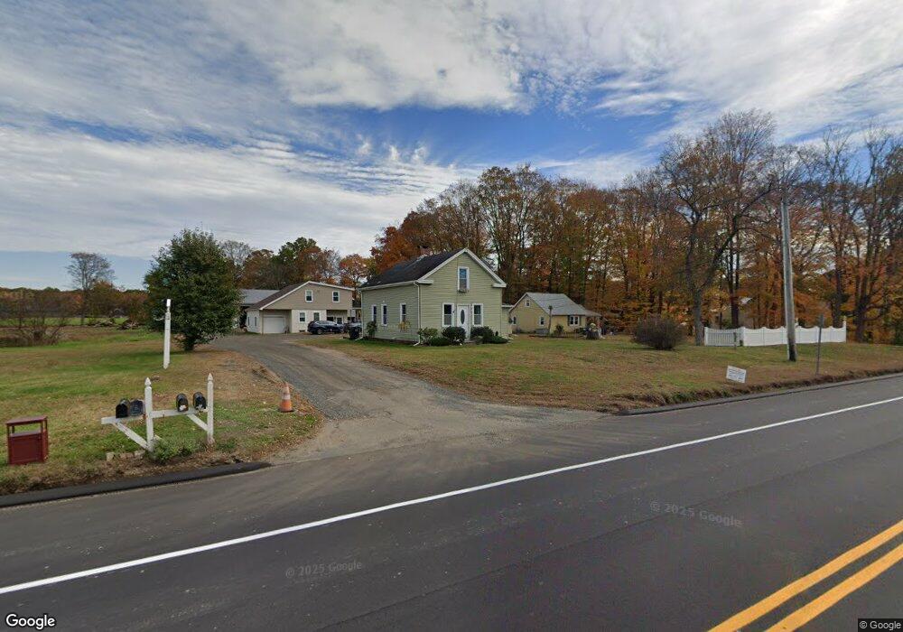
229 S Main St East Windsor, CT 06088
Estimated Value: $259,382 - $283,000
3
Beds
2
Baths
1,527
Sq Ft
$180/Sq Ft
Est. Value
About This Home
This home is located at 229 S Main St, East Windsor, CT 06088 and is currently estimated at $274,346, approximately $179 per square foot. 229 S Main St is a home located in Hartford County with nearby schools including Broad Brook Elementary School, East Windsor Middle School, and East Windsor High School.
Ownership History
Date
Name
Owned For
Owner Type
Purchase Details
Closed on
Oct 10, 2000
Sold by
Hall Elizabeth
Bought by
Bancroft Brian and Cote Lisa
Current Estimated Value
Home Financials for this Owner
Home Financials are based on the most recent Mortgage that was taken out on this home.
Original Mortgage
$75,000
Outstanding Balance
$27,430
Interest Rate
7.96%
Estimated Equity
$246,916
Create a Home Valuation Report for This Property
The Home Valuation Report is an in-depth analysis detailing your home's value as well as a comparison with similar homes in the area
Home Values in the Area
Average Home Value in this Area
Purchase History
| Date | Buyer | Sale Price | Title Company |
|---|---|---|---|
| Bancroft Brian | $100,000 | -- |
Source: Public Records
Mortgage History
| Date | Status | Borrower | Loan Amount |
|---|---|---|---|
| Open | Bancroft Brian | $75,000 |
Source: Public Records
Tax History Compared to Growth
Tax History
| Year | Tax Paid | Tax Assessment Tax Assessment Total Assessment is a certain percentage of the fair market value that is determined by local assessors to be the total taxable value of land and additions on the property. | Land | Improvement |
|---|---|---|---|---|
| 2025 | $3,764 | $139,270 | $20,170 | $119,100 |
| 2024 | $3,643 | $139,270 | $20,170 | $119,100 |
| 2023 | $3,371 | $92,160 | $44,100 | $48,060 |
| 2022 | $3,459 | $92,160 | $44,100 | $48,060 |
| 2021 | $3,355 | $92,160 | $44,100 | $48,060 |
| 2020 | $3,356 | $92,160 | $44,100 | $48,060 |
| 2019 | $3,286 | $92,160 | $44,100 | $48,060 |
| 2018 | $3,253 | $92,160 | $44,100 | $48,060 |
| 2017 | $3,370 | $98,910 | $43,340 | $55,570 |
| 2016 | $3,178 | $98,910 | $43,340 | $55,570 |
| 2015 | $2,998 | $98,910 | $43,340 | $55,570 |
| 2014 | $2,946 | $98,910 | $43,340 | $55,570 |
Source: Public Records
Map
Nearby Homes
- 372 Scantic Rd Unit 8
- 34 W River Rd
- 27 W River Rd
- 18 Cathy (Lot 17) Ln
- 17 Cathy (Lot 18) Ln
- 20 Cathy (Lot 16) Ln
- 19 Cathy (Lot 19) Ln
- 1333 Palisado Ave
- 22 Cathy (Lot 15) Ln
- 21 Ln
- 24 Cathy (Lot 14) Ln
- 23 Cathy (Lot 21) Ln
- 26 Cathy (Lot 13) Ln
- 24 MacKtown Rd
- 29 W River Rd
- 43 W River Rd
- 625 Palisado Ave Unit 310
- 957 Palisado Ave
- 47 Ferry Ln
- 20 Phelps Rd
- 237 S Main St
- 239 S Main St
- 248 S Main St
- 235 S Main St
- 257 S Main St Unit 17
- 257 S Main St
- 233 S Main St
- 231 S Main St
- 245 S Main St
- 252 S Main St
- 252 S Main St Unit E
- 227 S Main St Unit 227-229
- 227R S Main St
- 254 S Main St
- 225 S Main St
- 255 S Main St Unit MH
- 255 S Main St
- 255 S Main St Unit LEASE RESTAURANT
- 255 S Main St Unit MOBILE HOME PARK & L
- 255 S Main St Unit RESTAURANT ONLY