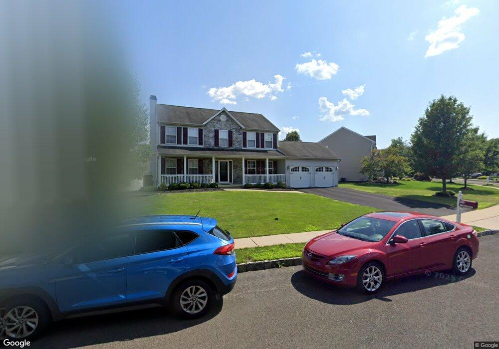
229 Snapdragon St Warrington, PA 18976
Estimated Value: $716,000 - $743,000
4
Beds
3
Baths
2,142
Sq Ft
$343/Sq Ft
Est. Value
About This Home
This home is located at 229 Snapdragon St, Warrington, PA 18976 and is currently estimated at $735,179, approximately $343 per square foot. 229 Snapdragon St is a home located in Bucks County with nearby schools including Mill Creek Elementary School, Unami Middle School, and Central Bucks High School - South.
Ownership History
Date
Name
Owned For
Owner Type
Purchase Details
Closed on
Jul 31, 2000
Sold by
Lower State Lp
Bought by
Curran Kevin J and Curran Rita J
Current Estimated Value
Home Financials for this Owner
Home Financials are based on the most recent Mortgage that was taken out on this home.
Original Mortgage
$232,181
Outstanding Balance
$83,235
Interest Rate
8.06%
Estimated Equity
$651,944
Create a Home Valuation Report for This Property
The Home Valuation Report is an in-depth analysis detailing your home's value as well as a comparison with similar homes in the area
Home Values in the Area
Average Home Value in this Area
Purchase History
| Date | Buyer | Sale Price | Title Company |
|---|---|---|---|
| Curran Kevin J | $253,700 | -- |
Source: Public Records
Mortgage History
| Date | Status | Borrower | Loan Amount |
|---|---|---|---|
| Open | Curran Kevin J | $232,181 |
Source: Public Records
Tax History Compared to Growth
Tax History
| Year | Tax Paid | Tax Assessment Tax Assessment Total Assessment is a certain percentage of the fair market value that is determined by local assessors to be the total taxable value of land and additions on the property. | Land | Improvement |
|---|---|---|---|---|
| 2025 | $7,517 | $40,720 | $7,640 | $33,080 |
| 2024 | $7,517 | $40,720 | $7,640 | $33,080 |
| 2023 | $6,959 | $40,720 | $7,640 | $33,080 |
| 2022 | $6,822 | $40,720 | $7,640 | $33,080 |
| 2021 | $6,746 | $40,720 | $7,640 | $33,080 |
| 2020 | $6,746 | $40,720 | $7,640 | $33,080 |
| 2019 | $6,705 | $40,720 | $7,640 | $33,080 |
| 2018 | $6,631 | $40,720 | $7,640 | $33,080 |
| 2017 | $6,541 | $40,720 | $7,640 | $33,080 |
| 2016 | $6,521 | $40,720 | $7,640 | $33,080 |
| 2015 | -- | $40,720 | $7,640 | $33,080 |
| 2014 | -- | $40,720 | $7,640 | $33,080 |
Source: Public Records
Map
Nearby Homes
- 803 Sweet Cherry St
- 3237 Pickertown Rd
- 406 Primrose Place
- 3302 Applewood Ct
- 3174 Wier Dr E Unit E
- 3146 Wier Dr E Unit E
- 3220 Wier Dr W Unit W
- 418 Homestead Cir
- 430 Homestead Cir
- 3159 Bristol Rd
- 73 Tradesville Dr Unit 80
- 73 Tradesville Dr
- 1 Mill Creek Dr
- 3 Mill Creek Dr
- 719 S Settlers Cir
- 5 Mill Creek Dr
- Redfield Elite Plan at Doylestown Walk
- Vetri Plan at Doylestown Walk
- 2 Mill Creek Dr
- 15 Mill Creek Dr
- 225 Snapdragon St
- 231 Snapdragon St
- 309 Aster Way
- 230 Snapdragon St
- 307 Aster Way
- 228 Snapdragon St
- 223 Snapdragon St
- 232 Snapdragon St
- 233 Snapdragon St
- 311 Aster Way
- 226 Snapdragon St
- 224 Snapdragon St
- 221 Snapdragon St
- 305 Aster Way
- 235 Snapdragon St
- 222 Snapdragon St
- 506 Starflower St
- 611 Bellflower Blvd
- 310 Aster Way
- 504 Starflower St