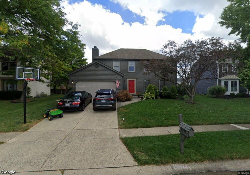
2294 Palmleaf Ct Columbus, OH 43235
Brookside Colony NeighborhoodEstimated Value: $400,143 - $450,000
4
Beds
3
Baths
2,021
Sq Ft
$215/Sq Ft
Est. Value
About This Home
This home is located at 2294 Palmleaf Ct, Columbus, OH 43235 and is currently estimated at $434,036, approximately $214 per square foot. 2294 Palmleaf Ct is a home located in Franklin County with nearby schools including Indian Run Elementary School, Ann Simpson Davis Middle School, and Dublin Scioto High School.
Ownership History
Date
Name
Owned For
Owner Type
Purchase Details
Closed on
Jun 25, 2024
Sold by
Clauss George R and Clauss Kay Lynn
Bought by
Clauss Family Revocable Trust and Clauss
Current Estimated Value
Purchase Details
Closed on
Jun 27, 1986
Bought by
Clauss George R and Clauss Kay L
Purchase Details
Closed on
Apr 1, 1986
Purchase Details
Closed on
Sep 1, 1985
Create a Home Valuation Report for This Property
The Home Valuation Report is an in-depth analysis detailing your home's value as well as a comparison with similar homes in the area
Home Values in the Area
Average Home Value in this Area
Purchase History
| Date | Buyer | Sale Price | Title Company |
|---|---|---|---|
| Clauss Family Revocable Trust | -- | None Listed On Document | |
| Clauss George R | $115,500 | -- | |
| -- | -- | -- | |
| -- | -- | -- |
Source: Public Records
Tax History
| Year | Tax Paid | Tax Assessment Tax Assessment Total Assessment is a certain percentage of the fair market value that is determined by local assessors to be the total taxable value of land and additions on the property. | Land | Improvement |
|---|---|---|---|---|
| 2025 | $7,289 | $120,510 | $36,090 | $84,420 |
| 2024 | $7,289 | $120,510 | $36,090 | $84,420 |
| 2023 | $7,186 | $120,505 | $36,085 | $84,420 |
| 2022 | $6,931 | $108,020 | $21,110 | $86,910 |
| 2021 | $7,044 | $108,020 | $21,110 | $86,910 |
| 2020 | $7,001 | $108,020 | $21,110 | $86,910 |
| 2019 | $6,491 | $88,660 | $17,610 | $71,050 |
| 2018 | $5,814 | $88,660 | $17,610 | $71,050 |
| 2017 | $5,993 | $88,660 | $17,610 | $71,050 |
| 2016 | $5,080 | $70,600 | $16,940 | $53,660 |
| 2015 | $5,112 | $70,600 | $16,940 | $53,660 |
| 2014 | $5,117 | $70,600 | $16,940 | $53,660 |
| 2013 | $2,598 | $70,595 | $16,940 | $53,655 |
Source: Public Records
Map
Nearby Homes
- 2062 Decker Ct
- 6924 Spruce Pine Dr
- 2487 Timbers Edge Ln Unit 2487
- 2546 Timberside Dr Unit 2546
- 7155 Asheville Park Dr
- 2026 Sawbury Blvd
- 2001 Sawbury Blvd Unit 2001
- 2024 Sawbury Blvd
- 2469 Sandstrom Dr
- 7641 Old Foxe Ct
- 6747 Merwin Rd
- 2279 Fernleaf Ln
- 6789 Meadow Creek Dr Unit 101
- 2074 Hard Rd
- 7735 Schoolway Ct
- 7755 Tripoli Ct
- 7480 Gardenview Place
- 7847 Meadowhaven Blvd Unit 66
- 7853 Meadowhaven Blvd Unit 63
- 7887 Thornfield Ln Unit 50
- 2302 Palmleaf Ct
- 2286 Palmleaf Ct
- 2267 Starleaf Ln
- 2275 Starleaf Ln
- 2259 Starleaf Ln
- 2310 Palmleaf Ct
- 2278 Palmleaf Ct
- 2311 Palmleaf Ct
- 2283 Starleaf Ln
- 2303 Palmleaf Ct
- 2251 Starleaf Ln
- 2287 Palmleaf Ct
- 2295 Palmleaf Ct
- 2319 Palmleaf Ct
- 2270 Palmleaf Ct
- 7361 Mapleleaf Blvd
- 2262 Starleaf Ln
- 7353 Mapleleaf Blvd
- 2271 Palmleaf Ct
- 7370 Palmleaf Ln
Your Personal Tour Guide
Ask me questions while you tour the home.