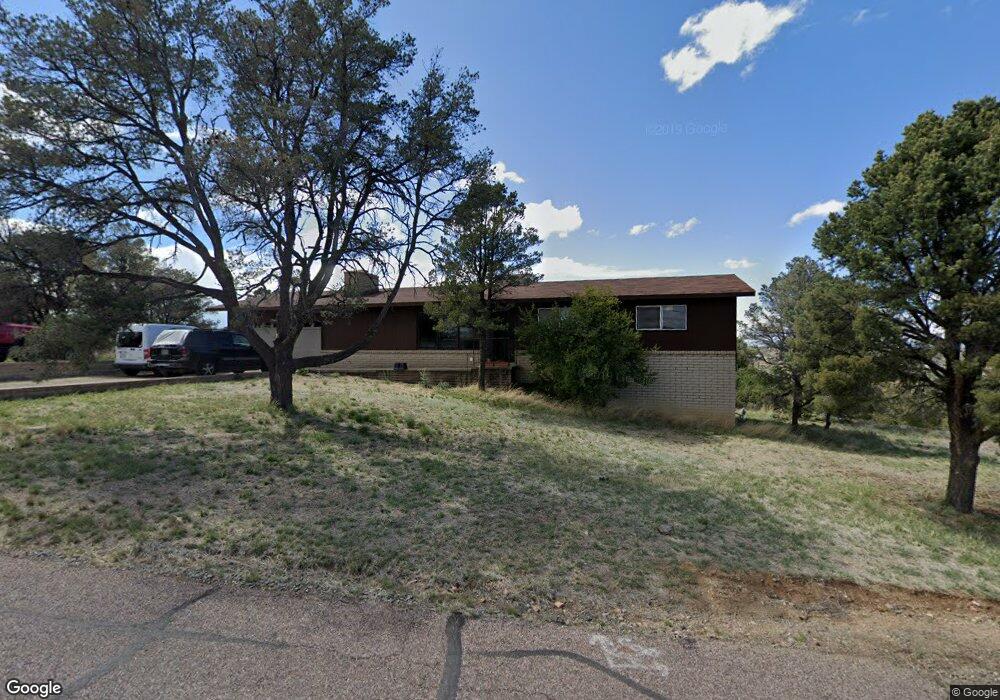
2298 Sandia Dr Prescott, AZ 86301
Estimated Value: $560,000 - $604,000
5
Beds
2
Baths
2,240
Sq Ft
$257/Sq Ft
Est. Value
About This Home
This home is located at 2298 Sandia Dr, Prescott, AZ 86301 and is currently estimated at $575,803, approximately $257 per square foot. 2298 Sandia Dr is a home located in Yavapai County with nearby schools including Taylor Hicks School, Granite Mountain Middle School, and Prescott Mile High Middle School.
Ownership History
Date
Name
Owned For
Owner Type
Purchase Details
Closed on
Jul 1, 2010
Sold by
Tanner Ralph R
Bought by
Tanner Marian F
Current Estimated Value
Purchase Details
Closed on
Feb 28, 2005
Sold by
Jeralds Jean Maissen
Bought by
Jeralds Sean K
Home Financials for this Owner
Home Financials are based on the most recent Mortgage that was taken out on this home.
Original Mortgage
$188,000
Outstanding Balance
$95,627
Interest Rate
5.66%
Mortgage Type
New Conventional
Estimated Equity
$480,176
Purchase Details
Closed on
Dec 7, 1999
Sold by
Woodall Clarence William and Woodall Madelin Sue
Bought by
Jeralds Sean K and Jeralds Jean Maissen
Home Financials for this Owner
Home Financials are based on the most recent Mortgage that was taken out on this home.
Original Mortgage
$125,900
Interest Rate
7.69%
Mortgage Type
New Conventional
Create a Home Valuation Report for This Property
The Home Valuation Report is an in-depth analysis detailing your home's value as well as a comparison with similar homes in the area
Home Values in the Area
Average Home Value in this Area
Purchase History
| Date | Buyer | Sale Price | Title Company |
|---|---|---|---|
| Tanner Marian F | -- | None Available | |
| Jeralds Sean K | -- | Transnation Title | |
| Jeralds Sean K | $139,900 | Capital Title Agency |
Source: Public Records
Mortgage History
| Date | Status | Borrower | Loan Amount |
|---|---|---|---|
| Open | Jeralds Sean K | $188,000 | |
| Closed | Jeralds Sean K | $125,900 |
Source: Public Records
Tax History Compared to Growth
Tax History
| Year | Tax Paid | Tax Assessment Tax Assessment Total Assessment is a certain percentage of the fair market value that is determined by local assessors to be the total taxable value of land and additions on the property. | Land | Improvement |
|---|---|---|---|---|
| 2026 | $1,548 | $38,726 | -- | -- |
| 2024 | $1,516 | $40,750 | -- | -- |
| 2023 | $1,516 | $31,775 | $0 | $0 |
| 2022 | $1,486 | $27,674 | $5,799 | $21,875 |
| 2021 | $1,549 | $27,463 | $5,184 | $22,279 |
| 2020 | $1,552 | $0 | $0 | $0 |
| 2019 | $1,532 | $0 | $0 | $0 |
| 2018 | $1,478 | $0 | $0 | $0 |
| 2017 | $1,410 | $0 | $0 | $0 |
| 2016 | $1,419 | $0 | $0 | $0 |
| 2015 | -- | $0 | $0 | $0 |
| 2014 | -- | $0 | $0 | $0 |
Source: Public Records
Map
Nearby Homes
- 401 Valley Place
- 2345 Shinnery Ln
- 2265 Sandia Dr
- 2630 Tabosa Dr
- 438 Jasmine Ln
- 2220 Sandia Dr
- 439 Foxfire Ln
- 2293 Sequoia Dr
- 407 Arena Dr
- 2240 Sumac Ct
- 2254 Sequoia Dr
- 418 Ironwood Ct
- 2303 Arthur Dr
- 538 S Lakeview Dr
- 364 Trailwood Dr
- 2722 College Heights Rd
- 2184 Desert Willow Dr
- 502-522 Talons Reach Way
- 2274 Mission Way
- 2800 Willow Creek Rd
- 2310 Sandia Dr
- 2290 Sandia Dr
- 2297 Sandia Dr
- 2293 Sandia Dr
- 2301 Sandia Dr
- 2285 Sandia Dr
- 385 Chaparral Dr
- 2330 Sandia Dr
- 2280 Sandia Dr
- 2311 Sandia Dr
- 380 Chaparral Dr
- 2321 Sandia Dr
- 2346 Sandia Dr
- 2340 Sandia Dr
- 2275 Sandia Dr
- 345 Chaparral Dr
- 2270 Sandia Dr
- 2350 Sandia Dr
- 340 Chaparral Dr Unit 1
- 345 Palo Verde Ln