
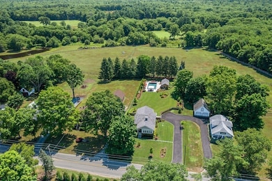
23 Bay State Rd Rehoboth, MA 02769
Estimated payment $22,192/month
Highlights
- Community Stables
- Cabana
- 99.32 Acre Lot
- Barn or Stable
- Scenic Views
- Landscaped Professionally
About This Home
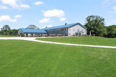
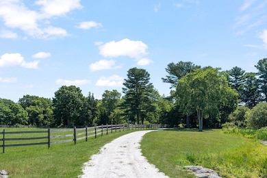
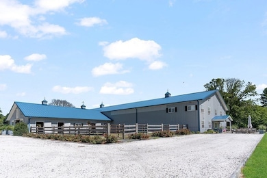
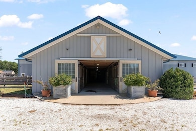
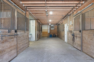
Fox Knoll Farm is an exceptional equine compound offering 86.33 acres of lush landscape with stunning clearings, meandering paths, and clearings for riding and turnout. The 8-stall barn with runouts, feed room, wash stall, and second-floor storage, offers an attached indoor with fiber footing. The first of three dwellings on the property is integral to the indoor ring. It is a two-story, one-bedroom apartment with a living room, kitchen, laundry, and office. The apartment has enormous windows that overlook the indoor ring. The two additional homes on the property are immaculately updated with construction completed in 2022. Each of the homes is 2-bedrooms with ensuites and additional half baths, open floor plans, top-of-the-line mechanicals and finishes, on-demand hot water, central AC, and full basements. This compound is a one-of-a-kind opportunity for the horse enthusiast. Lots included in the sale are as follows. 40/2, 40/3, 40/23, 40/6A, 39/94
Home Details
Home Type
- Single Family
Est. Annual Taxes
- $22,359
Year Built
- Built in 2022
Lot Details
- 99.32 Acre Lot
- Fenced Yard
- Landscaped Professionally
- Sprinkler System
- Cleared Lot
- Wooded Lot
Parking
- 4 Car Attached Garage
- Garage Door Opener
- Off-Street Parking
Home Design
- Ranch Style House
- Cellulose Insulation
- Blown-In Insulation
- Concrete Perimeter Foundation
Interior Spaces
- 8,314 Sq Ft Home
- Central Vacuum
- Wired For Sound
- Decorative Lighting
- 2 Fireplaces
- Scenic Vista Views
- Basement Fills Entire Space Under The House
- Attic
Kitchen
- Range
- Dishwasher
Flooring
- Wood
- Marble
- Tile
Bedrooms and Bathrooms
- 5 Bedrooms
Pool
- Cabana
- In Ground Pool
- Outdoor Shower
Outdoor Features
- Deck
- Porch
Horse Facilities and Amenities
- Horses Allowed On Property
- Paddocks
- Barn or Stable
Utilities
- Forced Air Heating and Cooling System
- Heating System Uses Natural Gas
- Heating System Uses Propane
- 220 Volts
- Private Water Source
- Tankless Water Heater
- Sewer Inspection Required for Sale
- Private Sewer
Additional Features
- Property is near public transit and schools
- Farm
Listing and Financial Details
- Assessor Parcel Number 2941450
Community Details
Overview
- No Home Owners Association
- Near Conservation Area
Amenities
- Shops
Recreation
- Community Pool
- Community Stables
Map
Home Values in the Area
Average Home Value in this Area
Tax History
| Year | Tax Paid | Tax Assessment Tax Assessment Total Assessment is a certain percentage of the fair market value that is determined by local assessors to be the total taxable value of land and additions on the property. | Land | Improvement |
|---|---|---|---|---|
| 2025 | $106 | $948,400 | $194,500 | $753,900 |
| 2024 | $9,958 | $876,600 | $192,800 | $683,800 |
| 2023 | $10,271 | $887,000 | $187,600 | $699,400 |
| 2022 | $11,223 | $885,800 | $186,400 | $699,400 |
| 2021 | $11,604 | $876,400 | $177,000 | $699,400 |
| 2020 | $11,498 | $876,400 | $177,000 | $699,400 |
| 2018 | $0 | $850,200 | $169,600 | $680,600 |
| 2017 | $12,217 | $972,700 | $170,200 | $802,500 |
| 2016 | $11,747 | $966,800 | $164,300 | $802,500 |
| 2015 | $10,558 | $857,700 | $157,100 | $700,600 |
| 2014 | $10,470 | $841,600 | $149,900 | $691,700 |
Property History
| Date | Event | Price | List to Sale | Price per Sq Ft |
|---|---|---|---|---|
| 10/22/2025 10/22/25 | For Sale | $3,950,000 | -- | $475 / Sq Ft |
Purchase History
| Date | Type | Sale Price | Title Company |
|---|---|---|---|
| Deed | $1,100,000 | -- | |
| Deed | $1,500 | -- |
Mortgage History
| Date | Status | Loan Amount | Loan Type |
|---|---|---|---|
| Open | $900,000 | Commercial | |
| Closed | $850,000 | Commercial | |
| Closed | $770,000 | Commercial | |
| Previous Owner | $200,000 | Commercial |
Source: MLS Property Information Network (MLS PIN)
MLS Number: 73446716
APN: REHO-000040-000000-000003
Disclaimer: Certain information contained herein is derived from information provided by parties other than Homes.com. All information provided is deemed reliable, but is not guaranteed to be accurate and should be independently verified.
![]() The property listing data and information, or the Images, set forth herein were provided to MLS Property Information Network, Inc. from third party sources, including sellers, lessors and public records, and were compiled by MLS Property Information Network, Inc. The property listing data and information, and the Images, are for the personal, non-commercial use of consumers having a good faith interest in purchasing or leasing listed properties of the type displayed to them and may not be used for any purpose other than to identify prospective properties which such consumers may have a good faith interest in purchasing or leasing. MLS Property Information Network, Inc. and its subscribers disclaim any and all representations and warranties as to the accuracy of the property listing data and information, or as to the accuracy of any of the Images, set forth herein.
The property listing data and information, or the Images, set forth herein were provided to MLS Property Information Network, Inc. from third party sources, including sellers, lessors and public records, and were compiled by MLS Property Information Network, Inc. The property listing data and information, and the Images, are for the personal, non-commercial use of consumers having a good faith interest in purchasing or leasing listed properties of the type displayed to them and may not be used for any purpose other than to identify prospective properties which such consumers may have a good faith interest in purchasing or leasing. MLS Property Information Network, Inc. and its subscribers disclaim any and all representations and warranties as to the accuracy of the property listing data and information, or as to the accuracy of any of the Images, set forth herein.
- 0 Winthrop St Unit 73180872
- 145 Winthrop St
- 139 Winthrop St
- 349 Anawan St
- 248 County
- 321 Winthrop St
- 10 Muriel Way
- 133 Winthrop St
- 1 Clubhouse Way
- 257 Anawan St
- 7 Ledge Hill Ln
- 15 Hickory Ridge Rd
- 111 Summer St
- 22 Bucklin Dr
- 20 School St
- Lot 11 Ledge Hill Ln
- 24 New St
- 0 Horton St Unit 73333337
- 23 Colonial Way
- 156 Rocky Hill Rd
- 201 Forsythe Cir Unit 407
- 210 County St Unit 3
- 101 Forsythe Cir Unit 405
- 101 Forsythe Cir Unit 613
- 101 Forsythe Cir Unit 308
- 3 Dailey St Unit B
- 509 S Main St Unit 3
- 25-27 Ferris Ave Unit 2
- 45 Oakdale St
- 292 Pleasant St
- 60 Phillips St Unit 8-4
- 60 Phillips St Unit 7-2
- 180 Parkview Dr
- 724 Beverage Hill Ave Unit 302
- 728 Beverage Hill Ave Unit 35
- 132 Tiffany St
- 75 Thacher Brook Cir
- 20 Newman Ave Unit 1-1102
- 20 Newman Ave Unit 1-1112
- 20 Newman Ave Unit 11-11303

Ask me questions while you tour the home.