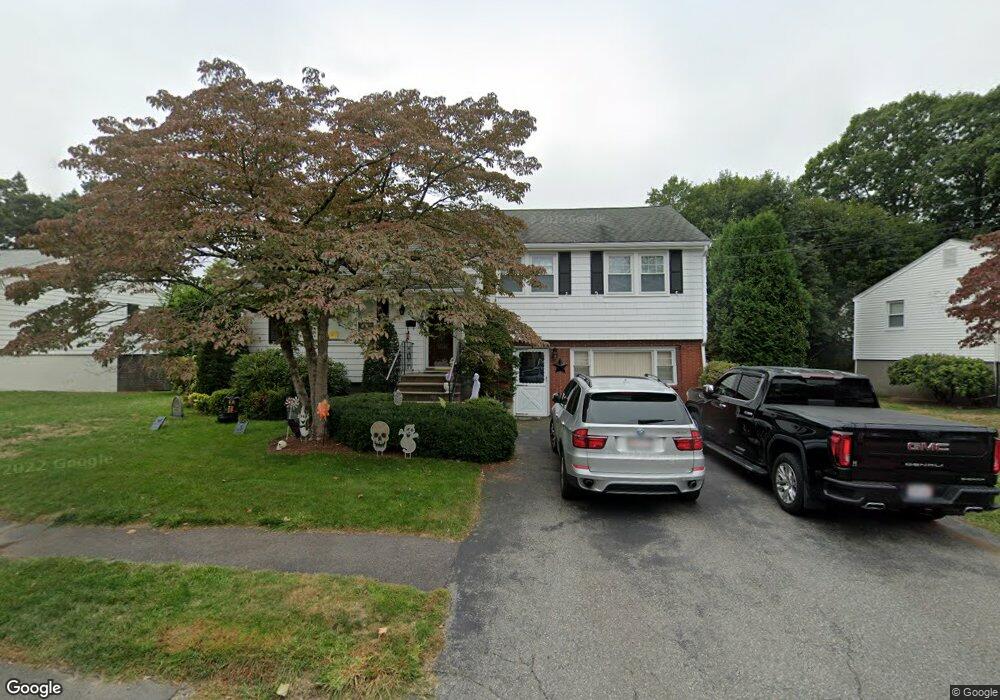
23 Beaver Brook Rd Waltham, MA 02452
North Waltham NeighborhoodEstimated Value: $815,000 - $963,000
4
Beds
2
Baths
2,211
Sq Ft
$396/Sq Ft
Est. Value
About This Home
This home is located at 23 Beaver Brook Rd, Waltham, MA 02452 and is currently estimated at $875,379, approximately $395 per square foot. 23 Beaver Brook Rd is a home located in Middlesex County with nearby schools including Northeast Elementary School, John F Kennedy Middle School, and Waltham Sr High School.
Ownership History
Date
Name
Owned For
Owner Type
Purchase Details
Closed on
Oct 18, 2022
Sold by
Duff Brian A and Duff Lynne M
Bought by
Duff Ret
Current Estimated Value
Purchase Details
Closed on
Jun 1, 1984
Bought by
Duff Brian A and Duff Lynne M
Create a Home Valuation Report for This Property
The Home Valuation Report is an in-depth analysis detailing your home's value as well as a comparison with similar homes in the area
Home Values in the Area
Average Home Value in this Area
Purchase History
| Date | Buyer | Sale Price | Title Company |
|---|---|---|---|
| Duff Ret | -- | None Available | |
| Duff Brian A | $122,500 | -- |
Source: Public Records
Mortgage History
| Date | Status | Borrower | Loan Amount |
|---|---|---|---|
| Previous Owner | Duff Brian A | $130,000 | |
| Previous Owner | Duff Brian A | $135,000 |
Source: Public Records
Tax History
| Year | Tax Paid | Tax Assessment Tax Assessment Total Assessment is a certain percentage of the fair market value that is determined by local assessors to be the total taxable value of land and additions on the property. | Land | Improvement |
|---|---|---|---|---|
| 2025 | $7,672 | $781,300 | $467,000 | $314,300 |
| 2024 | $7,288 | $756,000 | $445,200 | $310,800 |
| 2023 | $7,250 | $702,500 | $404,700 | $297,800 |
| 2022 | $7,489 | $672,300 | $396,600 | $275,700 |
| 2021 | $4,266 | $643,000 | $380,400 | $262,600 |
| 2020 | $7,091 | $593,400 | $356,200 | $237,200 |
| 2019 | $7,319 | $578,100 | $340,900 | $237,200 |
| 2018 | $3,950 | $529,300 | $315,700 | $213,600 |
| 2017 | $6,293 | $501,000 | $287,400 | $213,600 |
| 2016 | $5,983 | $488,800 | $275,200 | $213,600 |
| 2015 | $5,652 | $430,500 | $246,900 | $183,600 |
Source: Public Records
Map
Nearby Homes
- 100 Shirley Rd
- 43 S Cottage Rd Unit 43
- 43 Agassiz Ave
- 50 Moraine St
- 43-43A Chandler St
- 51 Harrington St Unit 51
- 256 Sycamore St Unit 256
- 31 Greensbrook Way
- 135 Marsh St
- 52 Hawthorne St Unit 1
- 144-146 White St
- 9 Henry St Unit 9
- 40 Knowles Rd
- 23 Centre Ave
- 53 Crestview Rd
- 910 Belmont St Unit 910
- 918 Belmont St
- 56 Ralph St Unit 3
- 21 Wellington Ln
- 17 Tennyson Rd
- 29 Beaver Brook Rd
- 76 Briarwood Rd
- 15 Beaver Brook Rd
- 80 Briarwood Rd
- 35 Beaver Brook Rd
- 24 Beaver Brook Rd
- 5 Beaver Brook Rd
- 30 Beaver Brook Rd
- 16 Beaver Brook Rd
- 70 Briarwood Rd
- 86 Briarwood Rd
- 79 Albemarle Rd
- 10 Beaver Brook Rd
- 10 Beaver Brook Rd Unit 1
- 41 Beaver Brook Rd
- 4 Beaver Brook Rd
- 40 Beaver Brook Rd
- 69 Albemarle Rd
- 92 Briarwood Rd
- 61 Mallard Way
Your Personal Tour Guide
Ask me questions while you tour the home.