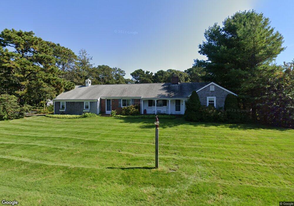
23 Brooksweld Ln West Dennis, MA 02670
West Dennis NeighborhoodEstimated Value: $852,000 - $1,062,049
3
Beds
2
Baths
1,501
Sq Ft
$647/Sq Ft
Est. Value
About This Home
This home is located at 23 Brooksweld Ln, West Dennis, MA 02670 and is currently estimated at $971,762, approximately $647 per square foot. 23 Brooksweld Ln is a home located in Barnstable County with nearby schools including Dennis-Yarmouth Regional High School and St. Pius X. School.
Ownership History
Date
Name
Owned For
Owner Type
Purchase Details
Closed on
Oct 17, 1997
Sold by
Obrien James T
Bought by
Mikula James R and Mikula Janet B
Current Estimated Value
Home Financials for this Owner
Home Financials are based on the most recent Mortgage that was taken out on this home.
Original Mortgage
$156,000
Interest Rate
7.46%
Mortgage Type
Purchase Money Mortgage
Create a Home Valuation Report for This Property
The Home Valuation Report is an in-depth analysis detailing your home's value as well as a comparison with similar homes in the area
Home Values in the Area
Average Home Value in this Area
Purchase History
| Date | Buyer | Sale Price | Title Company |
|---|---|---|---|
| Mikula James R | $195,000 | -- |
Source: Public Records
Mortgage History
| Date | Status | Borrower | Loan Amount |
|---|---|---|---|
| Open | Mikula James R | $50,000 | |
| Open | Mikula James R | $185,000 | |
| Closed | Mikula James R | $156,000 |
Source: Public Records
Tax History Compared to Growth
Tax History
| Year | Tax Paid | Tax Assessment Tax Assessment Total Assessment is a certain percentage of the fair market value that is determined by local assessors to be the total taxable value of land and additions on the property. | Land | Improvement |
|---|---|---|---|---|
| 2025 | $4,009 | $925,800 | $380,500 | $545,300 |
| 2024 | $3,898 | $888,000 | $366,000 | $522,000 |
| 2023 | $3,726 | $797,900 | $323,400 | $474,500 |
| 2022 | $3,739 | $667,600 | $316,300 | $351,300 |
| 2021 | $0 | $631,400 | $310,100 | $321,300 |
| 2020 | $0 | $634,400 | $342,800 | $291,600 |
| 2019 | $0 | $529,000 | $240,000 | $289,000 |
| 2018 | $0 | $585,900 | $319,900 | $266,000 |
| 2017 | $0 | $501,200 | $243,700 | $257,500 |
| 2016 | $3,277 | $501,800 | $281,800 | $220,000 |
| 2015 | $3,212 | $501,800 | $281,800 | $220,000 |
| 2014 | $2,896 | $456,100 | $236,100 | $220,000 |
Source: Public Records
Map
Nearby Homes
- 2 Rita Mary Way
- 14 Schoolhouse Ln
- 308 Old Main St
- 209 Main St Unit 3
- 209 Main St Unit 6
- 209 Main St Unit 1
- 209 Main St Unit 2
- 209 Main St Unit 4
- 209 Main St Unit 5
- 181 Pleasant St
- 45 Seth Ln
- 40 Kelley Rd
- 23 Doric Ave
- 178 School St
- 22 Powhatan Rd
- 29 Bass River Rd
- 401 Main St Unit 201
- 401 Main St Unit 101
- 18 Turner Ln
- 15 Sharon Rd
- 24 Old Field Rd
- 18 Old Field Rd
- 11 Brooksweld Ln
- 16 Brooksweld Ln
- 22 Brooksweld Ln
- 12 Old Field Rd
- 28 Brooksweld Ln
- 10 Brooksweld Ln
- 42 Brooksweld Ln
- 19 Old Field Rd
- 15 Chase Ave
- 3 Brooksweld Ln
- 17 Chase Ave
- 11 Chase Ave
- 25 Old Field Rd
- 103 Loring Ave
- 6 Brooksweld Ln
- 11 Old Field Rd
- 6 Old Field Rd
- 38 Old Field Rd