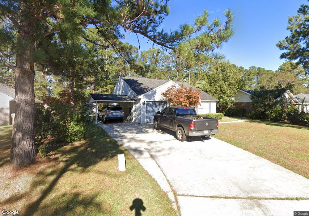
23 Cat Tail Ct Richmond Hill, GA 31324
Estimated Value: $276,908 - $307,000
3
Beds
2
Baths
1,226
Sq Ft
$243/Sq Ft
Est. Value
About This Home
This home is located at 23 Cat Tail Ct, Richmond Hill, GA 31324 and is currently estimated at $297,727, approximately $242 per square foot. 23 Cat Tail Ct is a home located in Bryan County with nearby schools including Richmond Hill Primary School, Dr. George Washington Carver Elementary School, and Richmond Hill Elementary School.
Ownership History
Date
Name
Owned For
Owner Type
Purchase Details
Closed on
Jun 14, 2008
Sold by
Long Kevin M
Bought by
Long Buffy
Current Estimated Value
Purchase Details
Closed on
May 26, 2004
Sold by
Nadig Ann Tigner
Bought by
Long Kevin M Albert J and Long Kevin M Betty J
Purchase Details
Closed on
Mar 25, 2004
Sold by
Nadig Elaine Ann
Bought by
Nadig Ann Tigner
Purchase Details
Closed on
Mar 22, 2004
Sold by
Nadig Elaine Ann
Bought by
Nadig Elaine Ann
Purchase Details
Closed on
Mar 19, 2004
Sold by
Nadig Anne T and Nadig Lawre
Bought by
Nadig Elaine Ann
Purchase Details
Closed on
Jun 7, 2002
Sold by
O'Neil Dennis L
Bought by
Nadig Anne T and Nadig Lawre
Purchase Details
Closed on
Mar 22, 2001
Sold by
Focht Morris G and Focht Gwe
Bought by
O'Neil Dennis L
Purchase Details
Closed on
Oct 1, 1998
Bought by
Focht Morris G and Focht Gwe
Purchase Details
Closed on
Dec 1, 1995
Purchase Details
Closed on
Jun 1, 1992
Create a Home Valuation Report for This Property
The Home Valuation Report is an in-depth analysis detailing your home's value as well as a comparison with similar homes in the area
Home Values in the Area
Average Home Value in this Area
Purchase History
| Date | Buyer | Sale Price | Title Company |
|---|---|---|---|
| Long Buffy | -- | -- | |
| Long Kevin M Albert J | $129,900 | -- | |
| Nadig Ann Tigner | -- | -- | |
| Nadig Elaine Ann | -- | -- | |
| Nadig Elaine Ann | -- | -- | |
| Nadig Anne T | $109,900 | -- | |
| O'Neil Dennis L | $95,000 | -- | |
| Focht Morris G | -- | -- | |
| -- | $69,200 | -- | |
| -- | $520,400 | -- |
Source: Public Records
Tax History Compared to Growth
Tax History
| Year | Tax Paid | Tax Assessment Tax Assessment Total Assessment is a certain percentage of the fair market value that is determined by local assessors to be the total taxable value of land and additions on the property. | Land | Improvement |
|---|---|---|---|---|
| 2024 | $2,395 | $83,200 | $24,000 | $59,200 |
| 2023 | $2,442 | $73,280 | $24,000 | $49,280 |
| 2022 | $2,207 | $70,560 | $24,000 | $46,560 |
| 2021 | $1,974 | $62,320 | $24,000 | $38,320 |
| 2020 | $1,708 | $58,840 | $24,000 | $34,840 |
| 2019 | $1,808 | $55,440 | $26,000 | $29,440 |
| 2018 | $1,452 | $49,200 | $22,000 | $27,200 |
| 2017 | $1,310 | $47,680 | $14,000 | $33,680 |
| 2016 | $1,295 | $46,800 | $14,000 | $32,800 |
| 2015 | $1,279 | $45,760 | $14,000 | $31,760 |
| 2014 | $1,307 | $46,680 | $14,000 | $32,680 |
Source: Public Records
Map
Nearby Homes
- 39 Cat Tail Ct
- 100 Cut Off Dr
- 79 Blue Wing Dr
- 100 Rice Gate Dr
- 56 Blue Wing Dr
- 122 Vining Way
- 310 Osprey Dr
- 292 Vining Way
- 12 Whippoorwill Ln E
- 70 Dove Ct
- 176 Shady Oak Cir
- 52 Sedgefield Ct
- 61 Quail Ln
- 207 Piercefield Dr
- 75 Golden Rod Loop
- 190 Cypress Point Dr
- 125 Cypress Pointe Dr
- 581 Laurel Hill Cir
- 155 Alexander Way
- 308 Boyd Dr