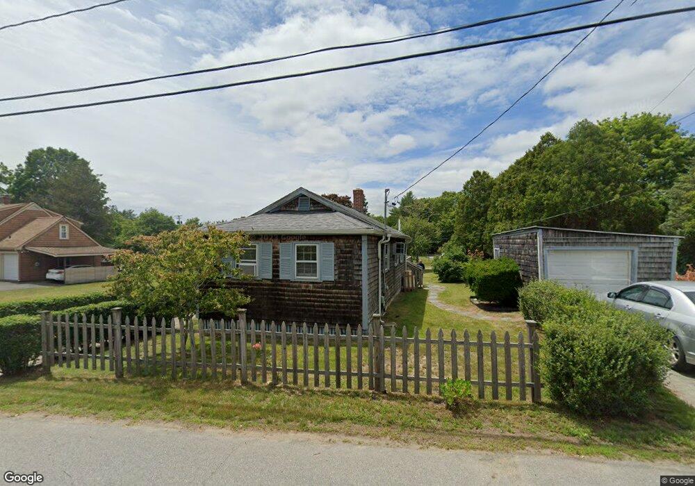
23 Connecticut Ave North Dartmouth, MA 02747
Smith Mills NeighborhoodEstimated Value: $315,401 - $347,000
1
Bed
1
Bath
779
Sq Ft
$431/Sq Ft
Est. Value
About This Home
This home is located at 23 Connecticut Ave, North Dartmouth, MA 02747 and is currently estimated at $335,850, approximately $431 per square foot. 23 Connecticut Ave is a home located in Bristol County with nearby schools including Dartmouth High School, Nazarene Christian Academy, and Friends Academy.
Ownership History
Date
Name
Owned For
Owner Type
Purchase Details
Closed on
May 9, 2023
Sold by
Champagne Michael D and Rosno Rea S
Bought by
23 Connecticut Ave Rt
Current Estimated Value
Purchase Details
Closed on
May 16, 2012
Sold by
Champagne Michael D
Bought by
Champagne Michael D and Rosno Rea S
Create a Home Valuation Report for This Property
The Home Valuation Report is an in-depth analysis detailing your home's value as well as a comparison with similar homes in the area
Home Values in the Area
Average Home Value in this Area
Purchase History
| Date | Buyer | Sale Price | Title Company |
|---|---|---|---|
| 23 Connecticut Ave Rt | -- | None Available | |
| Champagne Michael D | -- | -- | |
| Champagne Michael D | -- | -- |
Source: Public Records
Mortgage History
| Date | Status | Borrower | Loan Amount |
|---|---|---|---|
| Previous Owner | Champagne Michael D | $149,600 | |
| Previous Owner | Champagne Michael D | $155,000 |
Source: Public Records
Tax History Compared to Growth
Tax History
| Year | Tax Paid | Tax Assessment Tax Assessment Total Assessment is a certain percentage of the fair market value that is determined by local assessors to be the total taxable value of land and additions on the property. | Land | Improvement |
|---|---|---|---|---|
| 2025 | $2,182 | $241,100 | $120,600 | $120,500 |
| 2024 | $2,124 | $232,400 | $120,600 | $111,800 |
| 2023 | $2,141 | $221,000 | $120,600 | $100,400 |
| 2022 | $2,131 | $205,700 | $120,600 | $85,100 |
| 2021 | $1,960 | $181,000 | $117,100 | $63,900 |
| 2020 | $1,730 | $159,000 | $99,100 | $59,900 |
| 2019 | $1,674 | $154,300 | $93,200 | $61,100 |
| 2018 | $2,076 | $151,300 | $95,600 | $55,700 |
| 2017 | $1,566 | $147,200 | $90,100 | $57,100 |
| 2016 | $1,555 | $147,000 | $92,400 | $54,600 |
| 2015 | $1,436 | $136,600 | $81,000 | $55,600 |
| 2014 | $1,419 | $135,900 | $81,200 | $54,700 |
Source: Public Records
Map
Nearby Homes
- 320 Old Westport Rd
- 65 Cross Rd
- 312 Old Westport Rd
- 310 Old Westport Rd
- 53 Morton Ave
- 461 Reed Rd
- 735 Reed Rd
- 4 Sabrinas Way
- 4 Sabrina Way Unit A
- 4 Sabrina Way Unit C
- 4 Sabrina Way Unit B
- 4 Sabrina Way Unit D
- 28 Greystone Ave
- 3 Roller Coaster Way Unit Lot 1
- Lot 6 Rafael Rd
- 55 Lakeside Ave
- 818 Reed Rd
- 368 Cross Rd
- 135 Old Westport Rd
- 0 Undisclosed Unit 73376281
- 17 Connecticut Ave
- 6 Carter St
- 22 Connecticut Ave
- 10 Carter St
- 27 Connecticut Ave
- 14 Connecticut Ave
- 26 Connecticut Ave
- 7 Carter St
- 14 Carter St
- 11 Ramsey St
- 6 Ramsey St
- 11 Carter St
- 12 Connecticut Ave
- 18 Vermont Ave
- 8 Connecticut Ave
- 8 Connecticut Ave
- 37 Connecticut Ave
- 6 Connecticut Ave
- 19 Carter St
- 668 State Rd