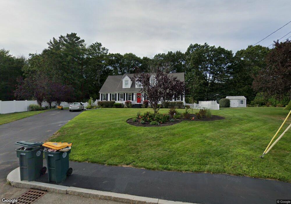
23 Crabtree Ln Abington, MA 02351
Estimated Value: $846,581 - $985,000
5
Beds
3
Baths
3,100
Sq Ft
$290/Sq Ft
Est. Value
About This Home
This home is located at 23 Crabtree Ln, Abington, MA 02351 and is currently estimated at $898,145, approximately $289 per square foot. 23 Crabtree Ln is a home located in Plymouth County with nearby schools including Woodsdale School, Beaver Brook Elementary School, and Abington Middle School.
Ownership History
Date
Name
Owned For
Owner Type
Purchase Details
Closed on
Aug 11, 2008
Sold by
National Transfer Svc
Bought by
Keleher Andrea
Current Estimated Value
Home Financials for this Owner
Home Financials are based on the most recent Mortgage that was taken out on this home.
Original Mortgage
$365,000
Interest Rate
6.49%
Mortgage Type
Purchase Money Mortgage
Purchase Details
Closed on
Apr 11, 2001
Sold by
Mckenna James G and Mckenna Carol
Bought by
Mcavoy Michael J and Mcavoy Kathleen E
Create a Home Valuation Report for This Property
The Home Valuation Report is an in-depth analysis detailing your home's value as well as a comparison with similar homes in the area
Home Values in the Area
Average Home Value in this Area
Purchase History
| Date | Buyer | Sale Price | Title Company |
|---|---|---|---|
| Keleher Andrea | $475,000 | -- | |
| National Transfer Svc | $566,666 | -- | |
| Mcavoy Michael J | $49,900 | -- |
Source: Public Records
Mortgage History
| Date | Status | Borrower | Loan Amount |
|---|---|---|---|
| Open | Mcavoy Michael J | $380,000 | |
| Closed | Mcavoy Michael J | $365,000 | |
| Previous Owner | Mcavoy Michael J | $136,800 |
Source: Public Records
Tax History Compared to Growth
Tax History
| Year | Tax Paid | Tax Assessment Tax Assessment Total Assessment is a certain percentage of the fair market value that is determined by local assessors to be the total taxable value of land and additions on the property. | Land | Improvement |
|---|---|---|---|---|
| 2025 | $10,116 | $774,600 | $253,100 | $521,500 |
| 2024 | $10,585 | $791,100 | $252,000 | $539,100 |
| 2023 | $10,112 | $711,600 | $219,400 | $492,200 |
| 2022 | $10,030 | $659,000 | $183,100 | $475,900 |
| 2021 | $9,090 | $551,600 | $174,500 | $377,100 |
| 2020 | $9,149 | $538,200 | $161,300 | $376,900 |
| 2019 | $10,210 | $521,800 | $161,300 | $360,500 |
| 2018 | $9,017 | $506,000 | $161,300 | $344,700 |
| 2017 | $9,311 | $448,800 | $161,300 | $287,500 |
| 2016 | $7,498 | $418,200 | $147,100 | $271,100 |
| 2015 | $7,067 | $415,700 | $147,100 | $268,600 |
Source: Public Records
Map
Nearby Homes
- 451 Lincoln St
- 89 Presidential Dr
- 209 Hancock St
- 10 Mccue Cir
- 164 Hancock St
- 5 Chamberlain St
- 28 Sylvan Ct
- 840 Hancock St
- 257 Rockland St Unit 257
- 32 Warren St
- 676 Bedford St
- 9 Karen Ln
- 221 Chestnut St
- 0 Bedford St
- 8 Kingswood Dr Unit D5
- 1042 Washington St
- 1353 Washington St
- 38 Lantern Ln
- 133 Andrew Ford Way
- 89 Andrew Ford Way