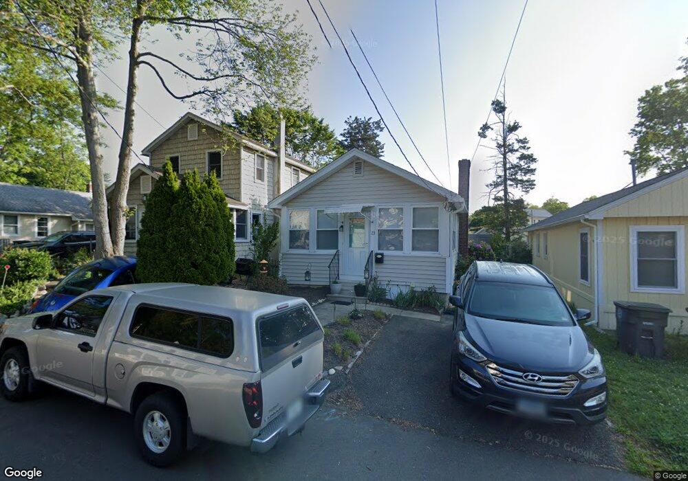
23 Daggett St Milford, CT 06460
Woodmont NeighborhoodEstimated Value: $365,308 - $460,000
2
Beds
1
Bath
704
Sq Ft
$600/Sq Ft
Est. Value
About This Home
This home is located at 23 Daggett St, Milford, CT 06460 and is currently estimated at $422,327, approximately $599 per square foot. 23 Daggett St is a home located in New Haven County with nearby schools including Calf Pen Meadow Elementary School, East Shore Middle School, and Joseph A. Foran High School.
Ownership History
Date
Name
Owned For
Owner Type
Purchase Details
Closed on
Nov 6, 2013
Sold by
Schreiner Anna E and Schreiner Philip J
Bought by
Schreiner Anna E and Schreiner Philip J
Current Estimated Value
Create a Home Valuation Report for This Property
The Home Valuation Report is an in-depth analysis detailing your home's value as well as a comparison with similar homes in the area
Home Values in the Area
Average Home Value in this Area
Purchase History
| Date | Buyer | Sale Price | Title Company |
|---|---|---|---|
| Schreiner Anna E | -- | -- | |
| Schreiner Anna E | -- | -- |
Source: Public Records
Tax History Compared to Growth
Tax History
| Year | Tax Paid | Tax Assessment Tax Assessment Total Assessment is a certain percentage of the fair market value that is determined by local assessors to be the total taxable value of land and additions on the property. | Land | Improvement |
|---|---|---|---|---|
| 2025 | $4,765 | $161,240 | $96,810 | $64,430 |
| 2024 | $4,699 | $161,240 | $96,810 | $64,430 |
| 2023 | $4,381 | $161,240 | $96,810 | $64,430 |
| 2022 | $4,297 | $161,240 | $96,810 | $64,430 |
| 2021 | $3,266 | $118,120 | $55,440 | $62,680 |
| 2020 | $3,270 | $118,120 | $55,440 | $62,680 |
| 2019 | $3,273 | $118,120 | $55,440 | $62,680 |
| 2018 | $3,277 | $118,120 | $55,440 | $62,680 |
| 2017 | $3,283 | $118,120 | $55,440 | $62,680 |
| 2016 | $3,481 | $125,050 | $60,480 | $64,570 |
| 2015 | $3,486 | $125,050 | $60,480 | $64,570 |
| 2014 | $3,404 | $125,050 | $60,480 | $64,570 |
Source: Public Records
Map
Nearby Homes
- 288 Welchs Point Rd
- 25 Summer Place
- 7 Orland St
- 44 Chester St
- 62 Long Island View Rd
- 44 Beachland Ave
- 26 Deerfield Ave
- 5 Vine St
- 119 Melba St
- 159 Wilcox Rd
- 97 Carriage Path S Unit 97
- 25 Carmen Rd
- 590 Gulf St
- 39 Point Lookout
- 12 Cardinal Dr
- 404 Buckingham Ave
- 470 Pond Point Ave
- 565 Pond Point Ave
- 571 Pond Point Ave
- 32 Morehouse Ave