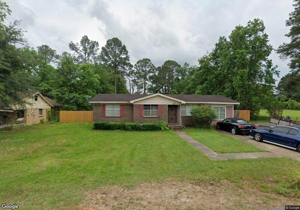
23 Davis Ave Saraland, AL 36571
Estimated Value: $89,000 - $141,695
3
Beds
1
Bath
1,246
Sq Ft
$98/Sq Ft
Est. Value
About This Home
This home is located at 23 Davis Ave, Saraland, AL 36571 and is currently estimated at $122,674, approximately $98 per square foot. 23 Davis Ave is a home located in Mobile County with nearby schools including Saraland Elementary School, Nelson Leon Adams Middle School/Saraland Middle School, and Saraland High School.
Ownership History
Date
Name
Owned For
Owner Type
Purchase Details
Closed on
Feb 21, 2005
Sold by
First National Bank Of Chicago
Bought by
Holcombe Kendall
Current Estimated Value
Home Financials for this Owner
Home Financials are based on the most recent Mortgage that was taken out on this home.
Original Mortgage
$28,800
Interest Rate
5.6%
Mortgage Type
Unknown
Purchase Details
Closed on
Sep 24, 2004
Sold by
Chaney Marcia V
Bought by
Bank One Na
Create a Home Valuation Report for This Property
The Home Valuation Report is an in-depth analysis detailing your home's value as well as a comparison with similar homes in the area
Home Values in the Area
Average Home Value in this Area
Purchase History
| Date | Buyer | Sale Price | Title Company |
|---|---|---|---|
| Holcombe Kendall | $32,000 | -- | |
| Bank One Na | $52,464 | -- |
Source: Public Records
Mortgage History
| Date | Status | Borrower | Loan Amount |
|---|---|---|---|
| Closed | Holcombe Kendall | $28,800 |
Source: Public Records
Tax History Compared to Growth
Tax History
| Year | Tax Paid | Tax Assessment Tax Assessment Total Assessment is a certain percentage of the fair market value that is determined by local assessors to be the total taxable value of land and additions on the property. | Land | Improvement |
|---|---|---|---|---|
| 2024 | $504 | $9,190 | $2,400 | $6,790 |
| 2023 | $480 | $9,120 | $1,400 | $7,720 |
| 2022 | $435 | $8,440 | $1,400 | $7,040 |
| 2021 | $352 | $7,030 | $1,120 | $5,910 |
| 2020 | $326 | $6,580 | $900 | $5,680 |
| 2019 | $311 | $6,360 | $0 | $0 |
| 2018 | $311 | $6,360 | $0 | $0 |
| 2017 | $311 | $6,360 | $0 | $0 |
| 2016 | $319 | $6,480 | $0 | $0 |
| 2013 | $199 | $4,980 | $0 | $0 |
Source: Public Records
Map
Nearby Homes
- 32 Everett Ave E
- 114 Bethel Forest Dr S
- 111 Bethel Forest Dr S
- 21 Frances St
- 228 Lucille St
- 127 Anderson Rd
- 13 Cypress Dr
- 0 Lind St
- 208 Strange Ave
- 127 Lillian Ave
- 410 Allen Cir
- 129 Lafayette Dr
- 325 Bryant Ct
- 306 Mignionette Ave
- 304 Celeste Rd
- 0 Highway 43 N Unit 7596009
- 425 Oakmont St
- 505 Norton Ave
- 321 Ferry Ave
- 127 Armond Dr
- 19 Davis Ave
- 24 Davis Ave
- 20 Davis Ave
- 17 Davis Ave
- 31 Davis Ave
- 32 Davis Ave
- 18 Bethel Forest Dr N
- 18 Davis Ave
- 22 Bethel Forest Dr N
- 14 Davis Ave
- 24 Bethel Forest Dr N
- 36 Davis Ave
- 16 Davis Ave
- 31 Highway 43 S
- 28 Bethel Forest Dr N
- 23 Norton Ave
- 10 Davis Ave
- 19 Bethel Forest Dr N
- 103 Norton Ave
- 13 Bethel Forest Dr N