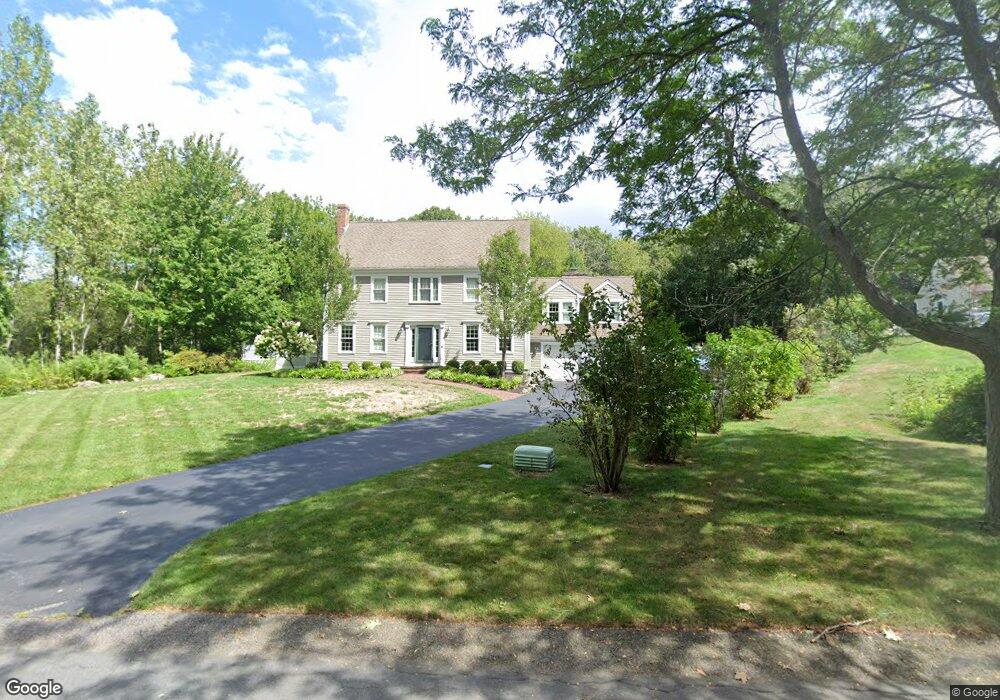
23 Franklin Rodgers Rd Hingham, MA 02043
Estimated Value: $1,419,000 - $2,106,000
4
Beds
3
Baths
2,600
Sq Ft
$671/Sq Ft
Est. Value
About This Home
This home is located at 23 Franklin Rodgers Rd, Hingham, MA 02043 and is currently estimated at $1,745,535, approximately $671 per square foot. 23 Franklin Rodgers Rd is a home located in Plymouth County with nearby schools including Plymouth River Elementary School, South Shore Conservatory of Music Preschool, and St. Paul Elementary School.
Ownership History
Date
Name
Owned For
Owner Type
Purchase Details
Closed on
Jul 23, 2012
Sold by
Woody Kevin and Brennan Claire
Bought by
Kodiak Rt and Woody Kevin P
Current Estimated Value
Purchase Details
Closed on
Aug 29, 1997
Sold by
Crumlish James K and Crumlish Loretta H
Bought by
Woody Kevin and Brennan Claire
Purchase Details
Closed on
Nov 1, 1993
Sold by
Conservatory Park Inc
Bought by
Crumlish James M and Crumlish Loretta H
Create a Home Valuation Report for This Property
The Home Valuation Report is an in-depth analysis detailing your home's value as well as a comparison with similar homes in the area
Home Values in the Area
Average Home Value in this Area
Purchase History
| Date | Buyer | Sale Price | Title Company |
|---|---|---|---|
| Kodiak Rt | -- | -- | |
| Woody Kevin | $380,000 | -- | |
| Crumlish James M | $135,000 | -- |
Source: Public Records
Mortgage History
| Date | Status | Borrower | Loan Amount |
|---|---|---|---|
| Previous Owner | Crumlish James M | $324,800 | |
| Previous Owner | Crumlish James M | $332,800 |
Source: Public Records
Tax History Compared to Growth
Tax History
| Year | Tax Paid | Tax Assessment Tax Assessment Total Assessment is a certain percentage of the fair market value that is determined by local assessors to be the total taxable value of land and additions on the property. | Land | Improvement |
|---|---|---|---|---|
| 2025 | $16,205 | $1,515,900 | $617,300 | $898,600 |
| 2024 | $15,504 | $1,428,900 | $617,300 | $811,600 |
| 2023 | $13,545 | $1,354,500 | $617,300 | $737,200 |
| 2022 | $13,166 | $1,138,900 | $553,500 | $585,400 |
| 2021 | $12,641 | $1,071,300 | $532,200 | $539,100 |
| 2020 | $12,352 | $1,071,300 | $532,200 | $539,100 |
| 2019 | $11,708 | $1,036,100 | $532,200 | $503,900 |
| 2018 | $12,195 | $1,036,100 | $532,200 | $503,900 |
| 2017 | $7,184 | $994,300 | $551,500 | $442,800 |
| 2016 | $12,092 | $968,100 | $525,300 | $442,800 |
| 2015 | $11,815 | $942,900 | $500,100 | $442,800 |
Source: Public Records
Map
Nearby Homes
- 171 Fort Hill St
- 7 Stevens Way
- 504 Tuckers Ln
- 5 Beals Cove Rd Unit E
- 15 Lewis Ct
- 191 South St
- 7 Lewis Ct
- 246 North St
- 21 Hersey St
- 10 Beals Cove Rd Unit C
- 16 Beal's Cove Rd Unit E
- 38 Smith Rd
- 36 Smith Rd
- 178 Hersey St
- 2 Winstead Rd
- 15 Bayberry Rd
- 109 Merryknoll Rd
- 9 Cranberry Ln
- 425 East St
- 30 Puritan Rd
- 21 Franklin Rodgers Rd
- 20 Franklin Rodgers Rd
- 19 Franklin Rodgers Rd
- 22 Franklin Rodgers Rd
- 18 Franklin Rodgers Rd
- 24 Isaac Sprague Dr
- 17 Franklin Rodgers Rd
- 24 Franklin Rodgers Rd
- 16 Franklin Rodgers Rd
- 22 Isaac Sprague Dr
- 16 Isaac Sprague Dr
- 18 Isaac Sprague Dr
- 20 Isaac Sprague Dr
- 15 Franklin Rodgers Rd
- 14 Isaac Sprague Dr
- 29 Franklin Rodgers Rd
- 14 Franklin Rodgers Rd
- 3 John Hazlitt Ln
- 27 Isaac Sprague Dr
- 12 Isaac Sprague Dr