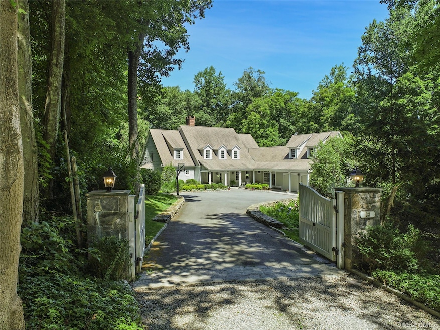
23 Kendall Rd Pound Ridge, NY 10576
Estimated payment $14,058/month
Highlights
- 7.09 Acre Lot
- Deck
- Main Floor Primary Bedroom
- Pound Ridge Elementary School Rated A-
- Wood Flooring
- Farmhouse Style Home
About This Home
HIGHEST and BEST due 10/14 by 12pm.
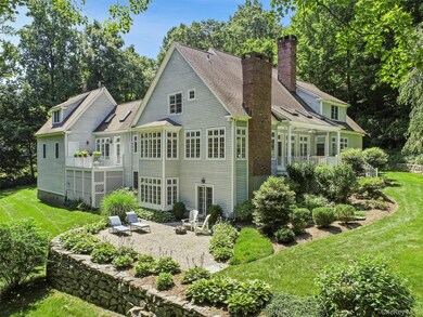
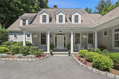
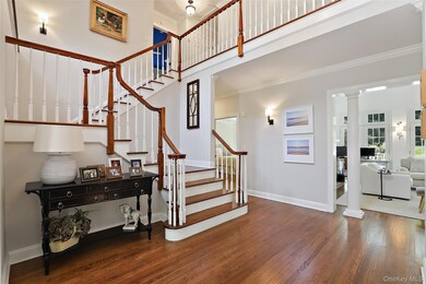
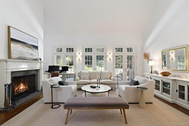
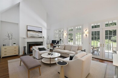
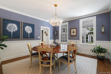
SOPHISTICATED FARMHOUSE - Impeccably appointed and sophisticated Country Farmhouse. Stunning spaces with beautifully proportioned rooms, high ceilings and virtual window walls to capture natural light and views. Neutral walls complement hardwood floors in a deep dark stain. Open floorplan allows for easy entertaining and everyday family living. Gracious Entrance Hall with formal Powder Room. Sun-filled Living
Room with soaring ceiling fireplace and doors to spacious rear deck. Formal Dining Room. Open concept Kitchen with new appliances & counters; breakfast area and Family Room with fireplace. Private Office for working remotely. First Floor Primary Suite with Dressing Room and luxurious, new Bath with radiant heat, soaking tub and frameless glass shower. Three additional Bedrooms plus second floor Sitting/Computer Room. All Five Bathrooms have been recently renovated & updated. Fully finished walkout Lower level with Recreation Room with fireplace, Gym and Wine Cellar. Located in Rock Rim Ponds, over seven fenced acres with gently rolling lawns, age-old trees and mature shrubs. Perfect privacy at the end of a cul-de-sac abutting acres of conservation lands. A fabulous offering!
Listing Agent
Ginnel Real Estate Brokerage Phone: 914-234-9234 License #40FI1134426 Listed on: 10/08/2025
Home Details
Home Type
- Single Family
Est. Annual Taxes
- $28,532
Year Built
- Built in 1998
Lot Details
- 7.09 Acre Lot
- Cul-De-Sac
HOA Fees
- $142 Monthly HOA Fees
Parking
- 2 Car Garage
- Driveway
Home Design
- Farmhouse Style Home
- Frame Construction
- Wood Siding
Interior Spaces
- 5,090 Sq Ft Home
- 2-Story Property
- High Ceiling
- Ceiling Fan
- 3 Fireplaces
- Storage
- Home Security System
Kitchen
- Breakfast Area or Nook
- Eat-In Kitchen
- Cooktop
- Dishwasher
- Kitchen Island
Flooring
- Wood
- Tile
Bedrooms and Bathrooms
- 4 Bedrooms
- Primary Bedroom on Main
- En-Suite Primary Bedroom
- Walk-In Closet
- Bathroom on Main Level
- Double Vanity
- Soaking Tub
Laundry
- Dryer
- Washer
Finished Basement
- Walk-Out Basement
- Laundry in Basement
Outdoor Features
- Deck
- Terrace
Schools
- Pound Ridge Elementary School
- Fox Lane Middle School
- Fox Lane High School
Utilities
- Central Air
- Hydro-Air Heating System
- Well
- Septic Tank
Community Details
- Association fees include common area maintenance
Listing and Financial Details
- Assessor Parcel Number 4600-000-000-09318-001-0011
Map
Home Values in the Area
Average Home Value in this Area
Tax History
| Year | Tax Paid | Tax Assessment Tax Assessment Total Assessment is a certain percentage of the fair market value that is determined by local assessors to be the total taxable value of land and additions on the property. | Land | Improvement |
|---|---|---|---|---|
| 2024 | $26,808 | $197,300 | $65,000 | $132,300 |
| 2023 | $25,706 | $197,300 | $65,000 | $132,300 |
| 2022 | $24,237 | $197,300 | $65,000 | $132,300 |
| 2021 | $23,930 | $197,300 | $65,000 | $132,300 |
| 2020 | $24,167 | $197,300 | $65,000 | $132,300 |
| 2019 | $24,360 | $197,300 | $65,000 | $132,300 |
| 2018 | $17,611 | $197,300 | $65,000 | $132,300 |
| 2017 | $0 | $225,000 | $65,000 | $160,000 |
| 2016 | $26,192 | $225,000 | $65,000 | $160,000 |
| 2015 | -- | $225,000 | $65,000 | $160,000 |
| 2014 | -- | $225,000 | $65,000 | $160,000 |
| 2013 | -- | $200,000 | $65,000 | $135,000 |
Property History
| Date | Event | Price | List to Sale | Price per Sq Ft |
|---|---|---|---|---|
| 10/23/2025 10/23/25 | Pending | -- | -- | -- |
| 10/19/2025 10/19/25 | Off Market | $2,200,000 | -- | -- |
| 10/08/2025 10/08/25 | For Sale | $2,200,000 | -- | $432 / Sq Ft |
Purchase History
| Date | Type | Sale Price | Title Company |
|---|---|---|---|
| Bargain Sale Deed | $1,250,000 | Stewart Title Insurance Co | |
| Interfamily Deed Transfer | -- | Chicago Title Insurance Co | |
| Interfamily Deed Transfer | -- | Attorneys Title |
Mortgage History
| Date | Status | Loan Amount | Loan Type |
|---|---|---|---|
| Previous Owner | $572,206 | Purchase Money Mortgage |
Source: OneKey® MLS
MLS Number: 921798
APN: 4600-000-000-09318-001-0011
Disclaimer: Certain information contained herein is derived from information provided by parties other than Homes.com. All information provided is deemed reliable, but is not guaranteed to be accurate and should be independently verified.
![]() The data relating to real estate for sale or lease on this web site comes in part from OneKey® MLS. Real estate listings held by brokerage firms other than Ten-X are marked with the OneKey® MLS logo or an abbreviated logo and detailed information about them includes the name of the listing broker.
The data relating to real estate for sale or lease on this web site comes in part from OneKey® MLS. Real estate listings held by brokerage firms other than Ten-X are marked with the OneKey® MLS logo or an abbreviated logo and detailed information about them includes the name of the listing broker.
IDX information is provided exclusively for personal, non-commercial use, and may not be used for any purpose other than to identify prospective properties consumers may be interested in purchasing.
Information is deemed reliable but not guaranteed.
Copyright 2025 OneKey® MLS. All rights reserved.
- 2856 Long Ridge Rd
- 1287 Rock Rimmon Rd
- 16 Gorge Ln
- 440 Long Ridge Rd
- 199 Upper Shad Rd
- 22 Blackberry Dr E
- 32 Joshua Hobby Ln
- 22 Joshua Hobby Ln
- 110 Erskine Rd
- 52 Mill Spring Ln
- 115 Mayapple Rd
- 43 Mill Rd
- 30 Dulan Dr
- 383 Pine Brook Rd
- 65 Mcintosh Rd
- 0 S Brook Dr Unit 170552650
- Lot #21 S Brook Dr
- Lot #5 S Brook Dr
- 147 Mianus River Rd
- 61 Shady Ln
