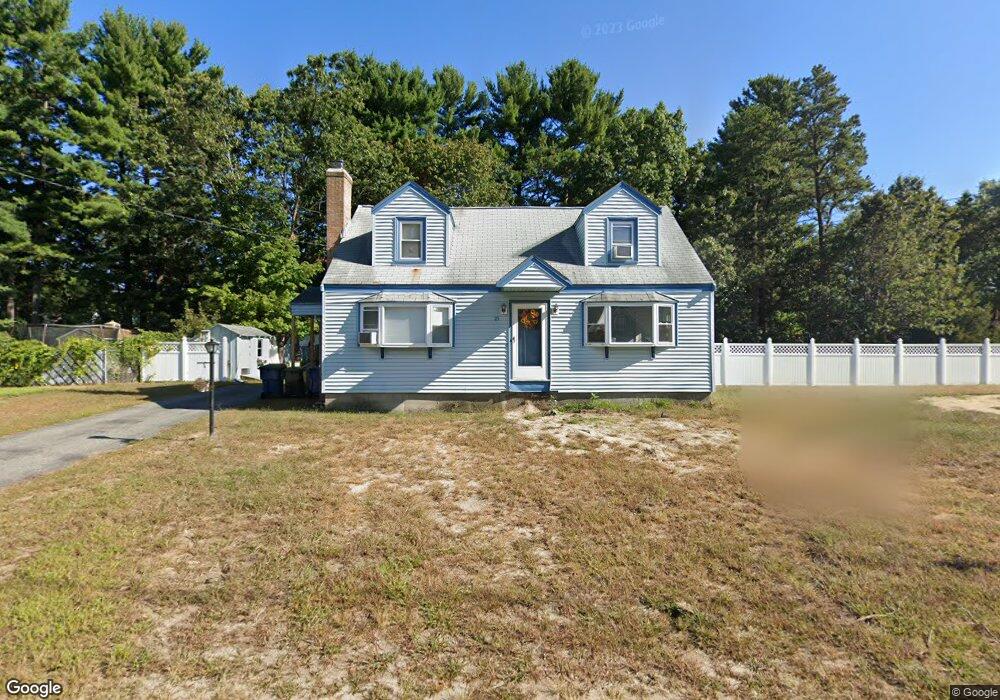
23 Kent St Tewksbury, MA 01876
Estimated Value: $542,000 - $685,000
4
Beds
2
Baths
1,306
Sq Ft
$471/Sq Ft
Est. Value
About This Home
This home is located at 23 Kent St, Tewksbury, MA 01876 and is currently estimated at $615,089, approximately $470 per square foot. 23 Kent St is a home located in Middlesex County with nearby schools including Heath-Brook Elementary School, John W. Wynn Middle School, and John F. Ryan Elementary School.
Ownership History
Date
Name
Owned For
Owner Type
Purchase Details
Closed on
Jun 22, 2018
Sold by
Locke Lloyd W
Bought by
Marsh Christi M and Sheehan Paul T
Current Estimated Value
Home Financials for this Owner
Home Financials are based on the most recent Mortgage that was taken out on this home.
Original Mortgage
$324,950
Outstanding Balance
$281,027
Interest Rate
4.5%
Mortgage Type
New Conventional
Estimated Equity
$334,062
Purchase Details
Closed on
Mar 21, 2006
Sold by
Locke Brenda A and Locke Lloyd W
Bought by
Locke Lloyd W
Home Financials for this Owner
Home Financials are based on the most recent Mortgage that was taken out on this home.
Original Mortgage
$288,800
Interest Rate
6.27%
Mortgage Type
Purchase Money Mortgage
Purchase Details
Closed on
Sep 20, 1996
Sold by
Andrews David D and Andrews Susan E
Bought by
Locke Lloyd W and Locke Brenda
Purchase Details
Closed on
Dec 29, 1988
Sold by
Destefano Raym R
Bought by
Andrews Susan E
Create a Home Valuation Report for This Property
The Home Valuation Report is an in-depth analysis detailing your home's value as well as a comparison with similar homes in the area
Home Values in the Area
Average Home Value in this Area
Purchase History
| Date | Buyer | Sale Price | Title Company |
|---|---|---|---|
| Marsh Christi M | $335,000 | -- | |
| Locke Lloyd W | -- | -- | |
| Locke Lloyd W | $150,450 | -- | |
| Andrews Susan E | $156,500 | -- |
Source: Public Records
Mortgage History
| Date | Status | Borrower | Loan Amount |
|---|---|---|---|
| Open | Marsh Christi M | $324,950 | |
| Previous Owner | Locke Lloyd W | $288,800 | |
| Previous Owner | Andrews Susan E | $18,000 | |
| Previous Owner | Andrews Susan E | $175,000 |
Source: Public Records
Tax History Compared to Growth
Tax History
| Year | Tax Paid | Tax Assessment Tax Assessment Total Assessment is a certain percentage of the fair market value that is determined by local assessors to be the total taxable value of land and additions on the property. | Land | Improvement |
|---|---|---|---|---|
| 2025 | $6,948 | $525,600 | $279,100 | $246,500 |
| 2024 | $6,913 | $516,300 | $265,800 | $250,500 |
| 2023 | $6,487 | $460,100 | $241,700 | $218,400 |
| 2022 | $6,226 | $409,600 | $210,300 | $199,300 |
| 2021 | $101,279 | $375,700 | $191,100 | $184,600 |
| 2020 | $5,657 | $354,200 | $181,900 | $172,300 |
| 2019 | $94,289 | $343,200 | $173,200 | $170,000 |
| 2018 | $5,079 | $314,900 | $173,200 | $141,700 |
| 2017 | $4,797 | $294,100 | $173,200 | $120,900 |
| 2016 | $4,678 | $286,100 | $173,200 | $112,900 |
| 2015 | $4,325 | $264,200 | $168,000 | $96,200 |
| 2014 | $4,160 | $258,200 | $168,000 | $90,200 |
Source: Public Records
Map
Nearby Homes
- 27 Marie St
- 70 Ronald Dr
- 31 Marie St
- 8 Boisvert Rd
- 6 Stonebury Way Unit 6
- 1501 Whipple Rd
- 1455 Main St Unit 4
- 1455 Main St Unit 10
- 1455 Main St Unit 8
- 14 Hinckley Rd
- 1042 Chandler St
- 1418 Main St Unit 201
- 142 Patrick Rd
- 100 Pine St
- 1325 Main
- 1334 Main St
- 111 Patrick Rd Unit 111
- 61 Patrick Rd
- 11 Orchard St
- 48 Whipple Rd