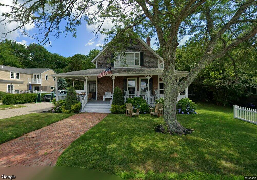
23 Landing Rd Duxbury, MA 02332
South Duxbury NeighborhoodEstimated Value: $952,000 - $1,043,000
3
Beds
1
Bath
1,489
Sq Ft
$678/Sq Ft
Est. Value
About This Home
This home is located at 23 Landing Rd, Duxbury, MA 02332 and is currently estimated at $1,009,562, approximately $678 per square foot. 23 Landing Rd is a home located in Plymouth County with nearby schools including Chandler Elementary School, Alden School, and Duxbury Middle School.
Ownership History
Date
Name
Owned For
Owner Type
Purchase Details
Closed on
Mar 31, 2025
Sold by
Gould Pamela
Bought by
Gould Boathouse Llc
Current Estimated Value
Purchase Details
Closed on
May 30, 2024
Sold by
Gould Edward B
Bought by
Gould Pamela
Purchase Details
Closed on
Dec 5, 2008
Sold by
Armstrong Ft and Catherine S Armstrong
Bought by
Mitchell Robert A and Mitchell Jennifer S
Home Financials for this Owner
Home Financials are based on the most recent Mortgage that was taken out on this home.
Original Mortgage
$414,400
Interest Rate
6.11%
Mortgage Type
Purchase Money Mortgage
Create a Home Valuation Report for This Property
The Home Valuation Report is an in-depth analysis detailing your home's value as well as a comparison with similar homes in the area
Home Values in the Area
Average Home Value in this Area
Purchase History
| Date | Buyer | Sale Price | Title Company |
|---|---|---|---|
| Gould Boathouse Llc | -- | None Available | |
| Gould Boathouse Llc | -- | None Available | |
| Gould Pamela | -- | None Available | |
| Gould Pamela | -- | None Available | |
| Gould Pamela | -- | None Available | |
| Mitchell Robert A | $543,000 | -- | |
| Mitchell Robert A | $543,000 | -- |
Source: Public Records
Mortgage History
| Date | Status | Borrower | Loan Amount |
|---|---|---|---|
| Previous Owner | Mitchell Robert A | $150,000 | |
| Previous Owner | Mitchell Robert A | $414,400 |
Source: Public Records
Tax History Compared to Growth
Tax History
| Year | Tax Paid | Tax Assessment Tax Assessment Total Assessment is a certain percentage of the fair market value that is determined by local assessors to be the total taxable value of land and additions on the property. | Land | Improvement |
|---|---|---|---|---|
| 2025 | $9,586 | $945,400 | $635,600 | $309,800 |
| 2024 | $8,653 | $860,100 | $544,700 | $315,400 |
| 2023 | $9,183 | $859,000 | $617,000 | $242,000 |
| 2022 | $8,652 | $673,800 | $473,400 | $200,400 |
| 2021 | $7,383 | $509,900 | $305,900 | $204,000 |
| 2020 | $6,892 | $470,100 | $277,200 | $192,900 |
| 2019 | $7,054 | $480,500 | $273,700 | $206,800 |
| 2018 | $6,948 | $458,300 | $239,000 | $219,300 |
| 2017 | $7,088 | $457,000 | $244,600 | $212,400 |
| 2016 | $6,872 | $441,900 | $229,500 | $212,400 |
| 2015 | $6,894 | $441,900 | $229,500 | $212,400 |
Source: Public Records
Map
Nearby Homes
- 10 Summerhouse Ln
- 59 Priscilla Ave
- 66 Seabury Point Rd
- 6 Priscilla Rd
- 117 Soule Ave
- 19 Flint Locke Dr
- 30 Cushing Dr
- 20 Island Creek Rd
- 124 Evergreen St
- 104 Standish St
- 65 Myles View Dr
- 53 Bay Farm Rd Unit 53
- 5 Page Ave
- 0 Standish St
- 80 Parks St Unit 6
- 80 Parks St Unit 5
- 40 Bay Farm Rd Unit 40
- 65 Tussock Brook Rd
- 18 Atwood St
- 68 Depot St
- 27 Landing Rd
- 17 Landing Rd
- 30 Landing Rd
- 33 Landing Rd
- 58 Beachwood Ln
- 58 Beachwood Ln Unit 58
- 9 Landing Rd
- 36 Landing Rd
- 38 Landing Rd
- 59 Beachwood Ln
- 43 Landing Rd
- 401 Bay Rd
- 405 Bay Rd
- 46 Landing Rd
- 46 Landing Road(winter Rental)
- 5 Surfside W Unit Winter
- 5 Surfside W Unit weekly
- 5 Surfside W
- 0 Bay Rd
- 379 Bay Rd