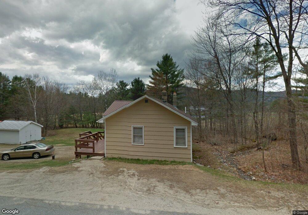
23 Martin Rd Rumford, ME 04276
Estimated Value: $152,000 - $182,155
--
Bed
--
Bath
970
Sq Ft
$173/Sq Ft
Est. Value
About This Home
This home is located at 23 Martin Rd, Rumford, ME 04276 and is currently estimated at $168,289, approximately $173 per square foot. 23 Martin Rd is a home with nearby schools including Rumford Elementary School, Meroby Elementary School, and Mountain Valley Middle School.
Ownership History
Date
Name
Owned For
Owner Type
Purchase Details
Closed on
Jun 23, 2021
Sold by
Mcpherson Robert A
Bought by
Laurinaitis Deborah and Mcpherson Robert A
Current Estimated Value
Create a Home Valuation Report for This Property
The Home Valuation Report is an in-depth analysis detailing your home's value as well as a comparison with similar homes in the area
Home Values in the Area
Average Home Value in this Area
Purchase History
| Date | Buyer | Sale Price | Title Company |
|---|---|---|---|
| Laurinaitis Deborah | -- | None Available |
Source: Public Records
Tax History Compared to Growth
Tax History
| Year | Tax Paid | Tax Assessment Tax Assessment Total Assessment is a certain percentage of the fair market value that is determined by local assessors to be the total taxable value of land and additions on the property. | Land | Improvement |
|---|---|---|---|---|
| 2024 | $2,038 | $122,600 | $28,000 | $94,600 |
| 2023 | $1,943 | $87,600 | $20,000 | $67,600 |
| 2022 | $1,943 | $87,600 | $20,000 | $67,600 |
| 2021 | $1,967 | $87,600 | $20,000 | $67,600 |
| 2020 | $1,980 | $87,600 | $20,000 | $67,600 |
| 2019 | $1,657 | $54,320 | $11,500 | $42,820 |
| 2018 | $1,616 | $54,320 | $11,500 | $42,820 |
| 2017 | $1,567 | $54,320 | $11,500 | $42,820 |
| 2016 | $1,521 | $54,320 | $11,500 | $42,820 |
| 2015 | $1,491 | $54,320 | $11,500 | $42,820 |
| 2014 | $1,464 | $54,320 | $11,500 | $42,820 |
Source: Public Records
Map
Nearby Homes
- 00 E Bethel Rd
- 21 Mill Hill Rd
- 2165 Main St
- 15 Off Howard Pond Small Rd
- Map 240 Lot 1 Map 239 Lot 4
- 101 S Shore Rd
- 42A Stearns Hill Rd
- 390 Howard Pond Rd
- L15 & 18 Off Howard Pond & Small Rd
- L18 Off Howard Pond & Small Rd
- TBD Plumbago Mountain
- 39 Katie View Rd
- 17 Blackberry Ln
- 1019 U S Highway 2
- 672 Meadow Ln
- 1359 Route 2
- 49 Balsam Rd
- TBD Tara's Way
- 1318 U S 2
- Lot 15-021 Taras Way
- 16 Martin Rd
- Lot# 10 Martin and Holman Rd
- 34 Martin Rd
- 8 Martin Rd
- 6 Martin Rd
- 7 Whippoorwill Rd
- 11 Whippoorwill Rd
- 17 Whippoorwill Rd
- 5 Whippoorwill Rd
- 1786 Route 2
- 00 Whippoorwill Road Ws
- 32 Whippoorwill Rd
- 1 Martin Rd
- 1 Route 2
- 1 Holman & Martin Rd
- 34 Whippoorwill Rd
- 1784 U S 2
- 39 Whippoorwill Rd
- 44 Whippoorwill Rd
- 49 Whippoorwill Rd