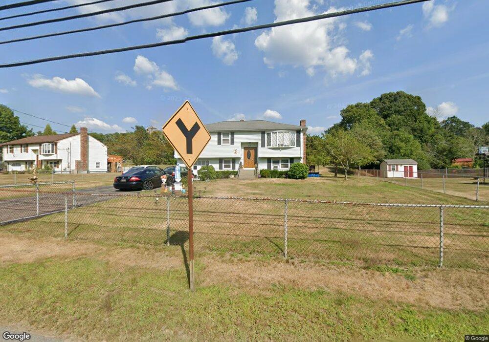
23 Norton Ave Taunton, MA 02780
Whittenton Junction NeighborhoodEstimated Value: $522,000 - $534,651
3
Beds
2
Baths
1,760
Sq Ft
$301/Sq Ft
Est. Value
About This Home
This home is located at 23 Norton Ave, Taunton, MA 02780 and is currently estimated at $528,913, approximately $300 per square foot. 23 Norton Ave is a home located in Bristol County with nearby schools including Benjamin Friedman Middle School, Joseph C. Chamberlain Elementary School, and Taunton High School.
Ownership History
Date
Name
Owned For
Owner Type
Purchase Details
Closed on
Jan 1, 1979
Bought by
Amaral Jose and Amaral Otilia M
Current Estimated Value
Create a Home Valuation Report for This Property
The Home Valuation Report is an in-depth analysis detailing your home's value as well as a comparison with similar homes in the area
Home Values in the Area
Average Home Value in this Area
Purchase History
| Date | Buyer | Sale Price | Title Company |
|---|---|---|---|
| Amaral Jose | -- | -- |
Source: Public Records
Mortgage History
| Date | Status | Borrower | Loan Amount |
|---|---|---|---|
| Open | Amaral Jose | $103,800 | |
| Closed | Amaral Jose | $41,000 | |
| Closed | Amaral Jose | $27,000 |
Source: Public Records
Tax History Compared to Growth
Tax History
| Year | Tax Paid | Tax Assessment Tax Assessment Total Assessment is a certain percentage of the fair market value that is determined by local assessors to be the total taxable value of land and additions on the property. | Land | Improvement |
|---|---|---|---|---|
| 2025 | $4,750 | $434,200 | $141,400 | $292,800 |
| 2024 | $4,380 | $391,400 | $141,400 | $250,000 |
| 2023 | $4,608 | $382,400 | $147,800 | $234,600 |
| 2022 | $4,315 | $327,400 | $114,600 | $212,800 |
| 2021 | $4,074 | $286,900 | $104,200 | $182,700 |
| 2020 | $3,990 | $268,500 | $104,200 | $164,300 |
| 2019 | $4,079 | $258,800 | $104,600 | $154,200 |
| 2018 | $3,906 | $248,500 | $105,600 | $142,900 |
| 2017 | $3,660 | $233,000 | $100,100 | $132,900 |
| 2016 | $3,531 | $225,200 | $97,200 | $128,000 |
| 2015 | $3,412 | $227,300 | $100,200 | $127,100 |
| 2014 | $3,297 | $225,700 | $100,200 | $125,500 |
Source: Public Records
Map
Nearby Homes
- 0 Norton Ave Unit 73362595
- 17 Davis St
- 193 Tremont St Unit 95
- 13 Northway
- 76 Twin Brook Ln
- 218 Dunbar St
- 108 Tremont St
- 110 Eldridge St Unit B
- 427 W Britannia St
- 193 Fremont St
- 214 Eldridge St
- 15 Chase St
- 13 Stanley Ave
- 96 Danforth St Unit 25
- 43 Pine St
- 43 Pine St Unit B
- 6 Grove Ave
- 45 Fisher St
- 34 Warren St
- 92 Highland Ave
- 37 Norton Ave
- 11 Norton Ave
- 10 Norton Ave
- 6 Norton Ave
- 0 Davis St
- 215 Tremont St
- 211 Tremont St
- 30 Norton Ave
- 1 Dunbar St
- 40 Norton Ave
- 221 Tremont St
- 0 Norton Ave Unit 71723528
- 0 Norton Ave Unit 71775252
- 0 Norton Ave Unit 71880458
- 0 Norton Ave Unit 71911907
- 0 Norton Ave Unit 71926764
- 0 Norton Ave Unit 71944774
- 0 Norton Ave Unit 72010834
- 2 Davis St
- 207 Tremont St