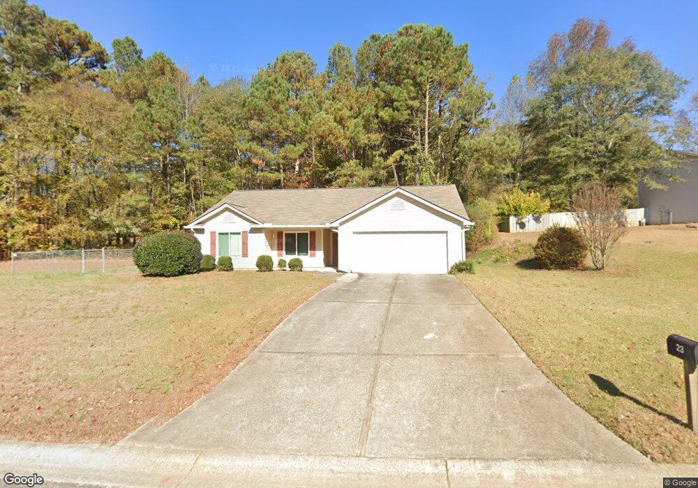
23 Robert Dr Braselton, GA 30517
Estimated Value: $293,000 - $330,000
Studio
2
Baths
1,306
Sq Ft
$239/Sq Ft
Est. Value
About This Home
This home is located at 23 Robert Dr, Braselton, GA 30517 and is currently estimated at $312,245, approximately $239 per square foot. 23 Robert Dr is a home located in Jackson County with nearby schools including West Jackson Elementary School, West Jackson Middle School, and Jackson County High School.
Ownership History
Date
Name
Owned For
Owner Type
Purchase Details
Closed on
Jul 23, 2007
Sold by
Not Provided
Bought by
Miller Laura
Current Estimated Value
Home Financials for this Owner
Home Financials are based on the most recent Mortgage that was taken out on this home.
Original Mortgage
$104,000
Outstanding Balance
$63,971
Interest Rate
6.65%
Mortgage Type
New Conventional
Estimated Equity
$248,274
Purchase Details
Closed on
Sep 21, 2001
Sold by
Relocation
Bought by
Wiley Kenneth Scott
Purchase Details
Closed on
Oct 20, 2000
Sold by
Garner Stephen P
Bought by
Webb William Frank
Purchase Details
Closed on
Jul 20, 2000
Sold by
Powell Bob
Bought by
Garner Stephen P
Purchase Details
Closed on
Apr 12, 1999
Sold by
French Kay S
Bought by
Powell Bob
Create a Home Valuation Report for This Property
The Home Valuation Report is an in-depth analysis detailing your home's value as well as a comparison with similar homes in the area
Home Values in the Area
Average Home Value in this Area
Purchase History
| Date | Buyer | Sale Price | Title Company |
|---|---|---|---|
| Miller Laura | $130,000 | -- | |
| Miller Laura | $130,000 | -- | |
| Wiley Kenneth Scott | $110,000 | -- | |
| Relocation | -- | -- | |
| Webb William Frank | $104,900 | -- | |
| Garner Stephen P | $25,000 | -- | |
| Powell Bob | -- | -- |
Source: Public Records
Mortgage History
| Date | Status | Borrower | Loan Amount |
|---|---|---|---|
| Open | Miller Laura | $104,000 | |
| Closed | Miller Laura | $13,000 | |
| Closed | Miller Laura | $104,000 |
Source: Public Records
Tax History
| Year | Tax Paid | Tax Assessment Tax Assessment Total Assessment is a certain percentage of the fair market value that is determined by local assessors to be the total taxable value of land and additions on the property. | Land | Improvement |
|---|---|---|---|---|
| 2025 | $1,960 | $73,440 | $14,880 | $58,560 |
| 2024 | $1,960 | $73,440 | $14,880 | $58,560 |
| 2023 | $1,980 | $65,680 | $14,880 | $50,800 |
| 2022 | $1,736 | $56,520 | $14,880 | $41,640 |
| 2021 | $1,747 | $56,520 | $14,880 | $41,640 |
| 2020 | $1,499 | $44,520 | $9,800 | $34,720 |
| 2019 | $1,520 | $44,520 | $9,800 | $34,720 |
| 2018 | $1,484 | $42,880 | $9,800 | $33,080 |
| 2017 | $1,473 | $42,242 | $9,800 | $32,442 |
| 2016 | $1,480 | $42,242 | $9,800 | $32,442 |
| 2015 | $1,298 | $36,898 | $6,000 | $30,898 |
| 2014 | $1,173 | $34,026 | $6,000 | $28,026 |
| 2013 | -- | $38,026 | $10,000 | $28,026 |
Source: Public Records
Map
Nearby Homes
- 298 Fox Creek Dr
- 1745 Liberty Park Dr
- 44 Fox Creek Dr
- 1620 Liberty Park Dr
- 111 Horned Owl Ave
- 1665 Liberty Park Dr
- 811 Walnut Woods Dr
- 751 Walnut Woods Dr
- 1036 Glenwyck Dr
- 1030 Glenwyck Dr
- 532 Davenport Rd
- 21 Duck Rd
- 83 Kings Dr
- 6647 Hwy 53
- 6647 Highway 53
- 6529 Highway 53
- 53 Ednaville Rd
- 156 Reisling Dr
- 1178 Pinnacle Dr
- 411 Meadow Lake Terrace
Your Personal Tour Guide
Ask me questions while you tour the home.