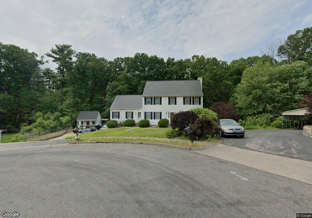
23 Vinnie Way Shrewsbury, MA 01545
Estimated Value: $751,823 - $907,000
4
Beds
3
Baths
2,356
Sq Ft
$364/Sq Ft
Est. Value
About This Home
This home is located at 23 Vinnie Way, Shrewsbury, MA 01545 and is currently estimated at $857,956, approximately $364 per square foot. 23 Vinnie Way is a home located in Worcester County with nearby schools including Calvin Coolidge Elementary School, Sherwood Middle School, and Oak Middle School.
Ownership History
Date
Name
Owned For
Owner Type
Purchase Details
Closed on
Apr 11, 2022
Sold by
Coppellotti Patricia D and Coppellotti Orlando
Bought by
Coppellotti Ft and Coppellotti
Current Estimated Value
Purchase Details
Closed on
Aug 18, 1994
Sold by
Westin Dev Corp
Bought by
Coppellotti Orlando and Coppellotti Patricia
Create a Home Valuation Report for This Property
The Home Valuation Report is an in-depth analysis detailing your home's value as well as a comparison with similar homes in the area
Home Values in the Area
Average Home Value in this Area
Purchase History
| Date | Buyer | Sale Price | Title Company |
|---|---|---|---|
| Coppellotti Ft | -- | None Available | |
| Coppellotti Ft | -- | None Available | |
| Coppellotti Ft | -- | None Available | |
| Coppellotti Orlando | $60,000 | -- | |
| Coppellotti Orlando | $60,000 | -- |
Source: Public Records
Mortgage History
| Date | Status | Borrower | Loan Amount |
|---|---|---|---|
| Previous Owner | Coppellotti Orlando | $84,300 | |
| Previous Owner | Coppellotti Orlando | $200,000 | |
| Previous Owner | Coppellotti Orlando | $150,000 |
Source: Public Records
Tax History Compared to Growth
Tax History
| Year | Tax Paid | Tax Assessment Tax Assessment Total Assessment is a certain percentage of the fair market value that is determined by local assessors to be the total taxable value of land and additions on the property. | Land | Improvement |
|---|---|---|---|---|
| 2025 | $88 | $728,800 | $235,200 | $493,600 |
| 2024 | $7,135 | $576,300 | $224,000 | $352,300 |
| 2023 | $7,561 | $576,300 | $224,000 | $352,300 |
| 2022 | $8,132 | $576,300 | $194,800 | $381,500 |
| 2021 | $7,091 | $537,600 | $181,200 | $356,400 |
| 2020 | $6,865 | $550,500 | $194,800 | $355,700 |
| 2019 | $6,389 | $508,300 | $167,400 | $340,900 |
| 2018 | $6,441 | $508,800 | $152,500 | $356,300 |
| 2017 | $6,206 | $483,700 | $138,100 | $345,600 |
| 2016 | $5,677 | $436,700 | $129,100 | $307,600 |
| 2015 | $5,149 | $390,100 | $110,700 | $279,400 |
Source: Public Records
Map
Nearby Homes
- 190 S Quinsigamond Ave Unit 102
- 105 S Quinsigamond Ave
- 73 S Quinsigamond Ave
- 259 S Quinsigamond Ave
- 241 Lake Ave
- 44 Ayrshire Rd
- 40 Shrewsbury Green Dr Unit A
- 42 Shrewsbury Green Dr Unit I
- 22 Shrewsbury Green Dr Unit C
- 135 Lake Ave
- 342 Lake Ave
- 26 Browne Rd
- 24 Sherbrook Ave
- 22 Sherbrook Ave
- 96 Lake Ave
- 276 Coburn Ave
- 10 Gleason Rd
- 79 Alvarado Ave
- 65 Lake Ave Unit 831
- 65 Lake Ave Unit 1008