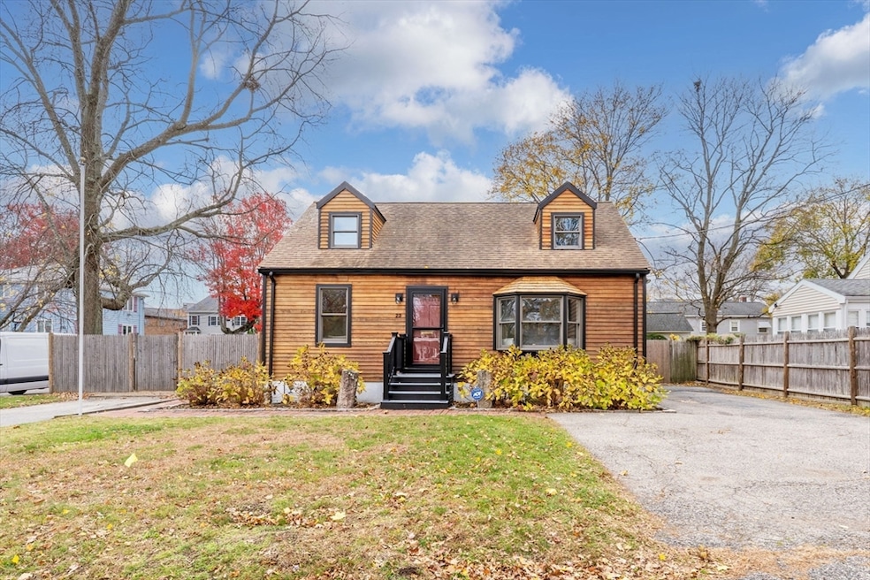
23 Yale Rd Arlington, MA 02474
East Arlington NeighborhoodEstimated payment $5,704/month
Highlights
- Cape Cod Architecture
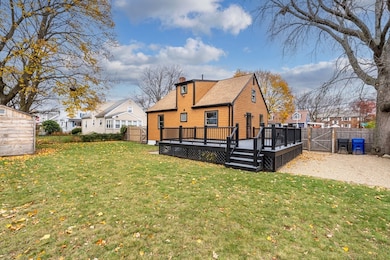
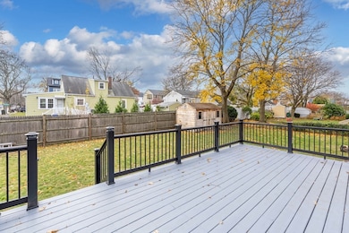
- Deck
- Wood Flooring
- Thompson School Rated A
- Property is near public transit
- 3-minute walk to James Lussiano Park
About This Home
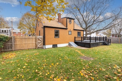
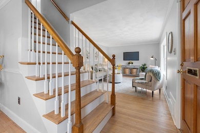
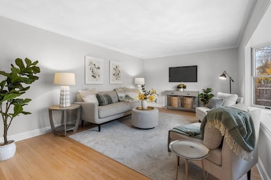
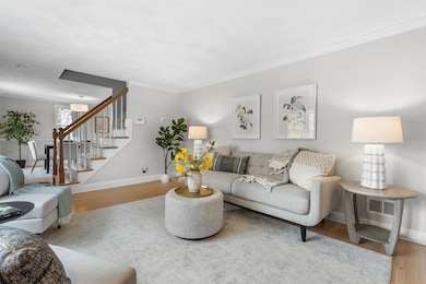
Offered for the first time in over 40 years, this impeccably maintained East Arlington Cape combines timeless charm with thoughtful updates throughout. This 3-bedroom, 2-full-bath home features beautifully refinished hardwood floors, a gracious formal dining room, and a bright, inviting living room. Situated on an expansive corner lot, the property offers a large fully fenced yard, a storage shed, and the rare convenience of two driveways. The finished basement significantly enhances the living space with a well-appointed family room, a custom built-in Murphy bed ideal for guests, and a dedicated utility and storage area. Don't miss this exceptional opportunity in one of Arlington’s most desirable neighborhoods.

Open House Schedule
-
Friday, November 21, 202512:00 to 1:00 pm11/21/2025 12:00:00 PM +00:0011/21/2025 1:00:00 PM +00:00Add to Calendar
-
Saturday, November 22, 202511:00 am to 1:00 pm11/22/2025 11:00:00 AM +00:0011/22/2025 1:00:00 PM +00:00Add to Calendar
Home Details
Home Type
- Single Family
Est. Annual Taxes
- $8,423
Year Built
- Built in 1954
Lot Details
- 6,508 Sq Ft Lot
- Fenced Yard
- Corner Lot
- Level Lot
- Property is zoned R1
Home Design
- Cape Cod Architecture
- Block Foundation
- Frame Construction
- Blown Fiberglass Insulation
- Shingle Roof
Interior Spaces
- Ceiling Fan
- Recessed Lighting
- Decorative Lighting
- 1 Fireplace
- Insulated Windows
- Bay Window
- Insulated Doors
Kitchen
- Stove
- Range with Range Hood
- Plumbed For Ice Maker
- Dishwasher
- Stainless Steel Appliances
Flooring
- Wood
- Wall to Wall Carpet
- Tile
- Vinyl
Bedrooms and Bathrooms
- 3 Bedrooms
- Primary Bedroom on Main
- 2 Full Bathrooms
- Bathtub with Shower
- Separate Shower
Laundry
- Dryer
- Washer
Partially Finished Basement
- Basement Fills Entire Space Under The House
- Interior Basement Entry
- Sump Pump
- Block Basement Construction
- Laundry in Basement
Home Security
- Home Security System
- Storm Doors
Parking
- 5 Car Parking Spaces
- Driveway
- Paved Parking
- Open Parking
- Off-Street Parking
Eco-Friendly Details
- Energy-Efficient Thermostat
Outdoor Features
- Bulkhead
- Deck
- Outdoor Storage
- Rain Gutters
- Porch
Location
- Property is near public transit
- Property is near schools
Utilities
- No Cooling
- Forced Air Heating System
- 1 Heating Zone
- Heating System Uses Natural Gas
- 200+ Amp Service
- Gas Water Heater
Listing and Financial Details
- Assessor Parcel Number M:039.0 B:0001 L:0011,321147
Community Details
Overview
- No Home Owners Association
- Near Conservation Area
Amenities
- Shops
- Coin Laundry
Recreation
- Park
- Jogging Path
- Bike Trail
Map
Home Values in the Area
Average Home Value in this Area
Tax History
| Year | Tax Paid | Tax Assessment Tax Assessment Total Assessment is a certain percentage of the fair market value that is determined by local assessors to be the total taxable value of land and additions on the property. | Land | Improvement |
|---|---|---|---|---|
| 2025 | $8,423 | $782,100 | $492,200 | $289,900 |
| 2024 | $7,743 | $731,200 | $467,600 | $263,600 |
| 2023 | $7,195 | $641,800 | $418,300 | $223,500 |
| 2022 | $6,930 | $606,800 | $393,700 | $213,100 |
| 2021 | $6,797 | $599,400 | $393,700 | $205,700 |
| 2020 | $6,629 | $599,400 | $393,700 | $205,700 |
| 2019 | $6,118 | $543,300 | $356,800 | $186,500 |
| 2018 | $6,367 | $524,900 | $338,400 | $186,500 |
| 2017 | $6,051 | $481,800 | $295,300 | $186,500 |
| 2016 | $5,615 | $438,700 | $252,200 | $186,500 |
| 2015 | $5,531 | $408,200 | $233,800 | $174,400 |
Property History
| Date | Event | Price | List to Sale | Price per Sq Ft |
|---|---|---|---|---|
| 11/18/2025 11/18/25 | For Sale | $949,000 | -- | $608 / Sq Ft |
Purchase History
| Date | Type | Sale Price | Title Company |
|---|---|---|---|
| Quit Claim Deed | -- | None Available | |
| Deed | $130,000 | -- |
Mortgage History
| Date | Status | Loan Amount | Loan Type |
|---|---|---|---|
| Previous Owner | $145,100 | No Value Available | |
| Previous Owner | $15,400 | No Value Available | |
| Previous Owner | $132,000 | No Value Available |
Source: MLS Property Information Network (MLS PIN)
MLS Number: 73455901
APN: ARLI-000039-000001-000011
Disclaimer: Certain information contained herein is derived from information provided by parties other than Homes.com. All information provided is deemed reliable, but is not guaranteed to be accurate and should be independently verified.
![]() The property listing data and information, or the Images, set forth herein were provided to MLS Property Information Network, Inc. from third party sources, including sellers, lessors and public records, and were compiled by MLS Property Information Network, Inc. The property listing data and information, and the Images, are for the personal, non-commercial use of consumers having a good faith interest in purchasing or leasing listed properties of the type displayed to them and may not be used for any purpose other than to identify prospective properties which such consumers may have a good faith interest in purchasing or leasing. MLS Property Information Network, Inc. and its subscribers disclaim any and all representations and warranties as to the accuracy of the property listing data and information, or as to the accuracy of any of the Images, set forth herein.
The property listing data and information, or the Images, set forth herein were provided to MLS Property Information Network, Inc. from third party sources, including sellers, lessors and public records, and were compiled by MLS Property Information Network, Inc. The property listing data and information, and the Images, are for the personal, non-commercial use of consumers having a good faith interest in purchasing or leasing listed properties of the type displayed to them and may not be used for any purpose other than to identify prospective properties which such consumers may have a good faith interest in purchasing or leasing. MLS Property Information Network, Inc. and its subscribers disclaim any and all representations and warranties as to the accuracy of the property listing data and information, or as to the accuracy of any of the Images, set forth herein.
- 6 Gordon Rd
- 27 Dartmouth St Unit 29
- 101 Arlington St
- 166 Arlington St
- 94 Rawson Rd Unit 94
- 12 Arizona Terrace Unit 2
- 111 Sharon St Unit 1
- 42-44 Warren St Unit 42
- 80 Broadway Unit PH
- 77 Warren St Unit A
- 395 Alewife Brook Pkwy Unit 2C
- 395 Alewife Brook Pkwy Unit PH E
- 63 Broadway Unit 1
- 31 Sharon St
- 69 Sterling St
- 327 Alewife Brook Pkwy Unit A
- 41 Palmer St Unit 43
- 44 Woods Ave Unit 44
- 582 High St Unit 2
- 29 Harvard Ave Unit 29
- 7 Patrick St
- 7 Patrick St Unit 2
- 89 Decatur St Unit 1
- 61 Decatur St
- 130 Everett St
- 40-42 Dartmouth St Unit 40
- 35 Bowdoin St Unit 35
- 6 Harris Cir Unit 9
- 10 Arizona Terrace Unit 4
- 22 Norcross St Unit 2
- 27 N Union St Unit 8
- 21A Mystic River Rd Unit 1
- 132 Broadway Unit 1
- 140 Jerome St
- 28 Rawson Rd Unit 28
- 120 Jerome St Unit 120
- 120 Jerome St
- 120 Jerome St Unit T
- 80 Broadway
- 137 Sharon St Unit 1