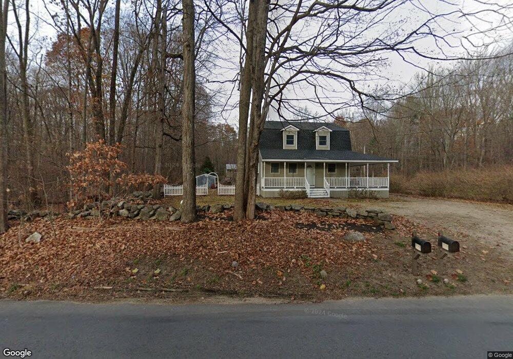
230 Brookfield Rd Charlton, MA 01507
Estimated Value: $404,000 - $493,000
3
Beds
2
Baths
1,456
Sq Ft
$309/Sq Ft
Est. Value
About This Home
This home is located at 230 Brookfield Rd, Charlton, MA 01507 and is currently estimated at $449,574, approximately $308 per square foot. 230 Brookfield Rd is a home located in Worcester County with nearby schools including Shepherd Hill Regional High School.
Ownership History
Date
Name
Owned For
Owner Type
Purchase Details
Closed on
Aug 11, 2023
Sold by
Cep Real Estate Llc
Bought by
Karrmann Michael J
Current Estimated Value
Home Financials for this Owner
Home Financials are based on the most recent Mortgage that was taken out on this home.
Original Mortgage
$300,000
Outstanding Balance
$292,436
Interest Rate
6.71%
Mortgage Type
Purchase Money Mortgage
Estimated Equity
$157,138
Purchase Details
Closed on
Jan 20, 2023
Sold by
Bartlett Dennis E
Bought by
Cep Real Estate Llc
Create a Home Valuation Report for This Property
The Home Valuation Report is an in-depth analysis detailing your home's value as well as a comparison with similar homes in the area
Home Values in the Area
Average Home Value in this Area
Purchase History
| Date | Buyer | Sale Price | Title Company |
|---|---|---|---|
| Karrmann Michael J | $375,000 | None Available | |
| Karrmann Michael J | $375,000 | None Available | |
| Cep Real Estate Llc | $125,000 | None Available | |
| Cep Real Estate Llc | $125,000 | None Available |
Source: Public Records
Mortgage History
| Date | Status | Borrower | Loan Amount |
|---|---|---|---|
| Open | Karrmann Michael J | $300,000 | |
| Closed | Karrmann Michael J | $300,000 |
Source: Public Records
Tax History Compared to Growth
Tax History
| Year | Tax Paid | Tax Assessment Tax Assessment Total Assessment is a certain percentage of the fair market value that is determined by local assessors to be the total taxable value of land and additions on the property. | Land | Improvement |
|---|---|---|---|---|
| 2025 | $4,342 | $390,100 | $69,200 | $320,900 |
| 2024 | $4,063 | $358,300 | $66,600 | $291,700 |
| 2023 | $3,468 | $285,000 | $64,100 | $220,900 |
| 2022 | $3,381 | $254,400 | $63,000 | $191,400 |
| 2021 | $1,512 | $201,900 | $61,500 | $140,400 |
| 2020 | $2,940 | $196,800 | $56,400 | $140,400 |
| 2019 | $1,375 | $196,800 | $56,400 | $140,400 |
| 2018 | $2,657 | $196,800 | $56,400 | $140,400 |
| 2017 | $1,324 | $174,700 | $51,300 | $123,400 |
| 2016 | $2,407 | $174,700 | $51,300 | $123,400 |
| 2015 | $2,344 | $174,700 | $51,300 | $123,400 |
| 2014 | $2,310 | $182,500 | $56,400 | $126,100 |
Source: Public Records
Map
Nearby Homes
- 204 Brookfield Rd
- 45 Jennings Rd
- 49 Jennings Rd
- 38 N Sullivan Rd
- Lot 3 0 N Sullivan Rd
- Lot 6 0 N Sullivan Rd
- Lot 5 0 N Sullivan Rd
- Lot 4 0 N Sullivan Rd
- 29, 31, 33 Ladd Rd
- 68 - 74 Sturbridge Rd
- 6 S Sullivan Rd
- 208 Sunset Dr
- 3 Cranberry Meadow Shore Rd
- 38 Stevens Park Rd
- 0 Worcester Rd
- 28 Southbridge Rd Unit 402
- 86 Jolicoeur Ave
- 57 Carpenter Hill Rd
- 199 Center Depot Rd
- 0 Trolley Crossing Rd
- 228 Brookfield Rd
- 224 Brookfield Rd
- 236 Brookfield Rd
- 238 Brookfield Rd
- 221 Brookfield Rd
- 221 Brookfield Rd
- 244 Brookfield Rd
- 209 Brookfield Rd
- 256 Brookfield Rd
- 258 Brookfield Rd
- 205 Brookfield Rd
- 251 Brookfield Rd
- 253 Brookfield Rd
- 63 Jennings Dr
- 260 Brookfield Rd
- 201 Brookfield Rd
- 61 Jennings Rd
- 264 Brookfield Rd
- 261 Brookfield Rd
- 202 Brookfield Rd