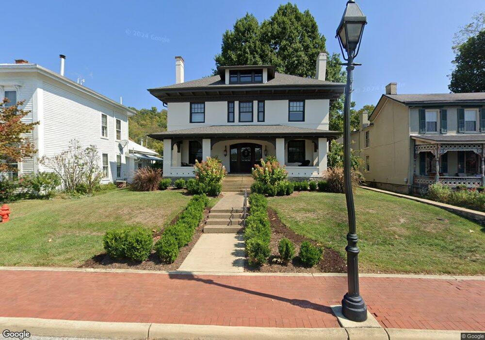
230 N Front St Ripley, OH 45167
Estimated Value: $178,000 - $354,000
4
Beds
2
Baths
3,024
Sq Ft
$100/Sq Ft
Est. Value
About This Home
This home is located at 230 N Front St, Ripley, OH 45167 and is currently estimated at $302,491, approximately $100 per square foot. 230 N Front St is a home with nearby schools including Ripley Union Lewis Huntington Elementary School, Ripley Union Lewis Huntington Middle School, and Ripley-Union-Lewis-Huntington High School.
Ownership History
Date
Name
Owned For
Owner Type
Purchase Details
Closed on
Dec 8, 2009
Sold by
Martin William
Bought by
Benintendi Christopher and Benintendi Jill
Current Estimated Value
Home Financials for this Owner
Home Financials are based on the most recent Mortgage that was taken out on this home.
Original Mortgage
$215,000
Outstanding Balance
$140,667
Interest Rate
4.96%
Mortgage Type
New Conventional
Estimated Equity
$161,824
Create a Home Valuation Report for This Property
The Home Valuation Report is an in-depth analysis detailing your home's value as well as a comparison with similar homes in the area
Home Values in the Area
Average Home Value in this Area
Purchase History
| Date | Buyer | Sale Price | Title Company |
|---|---|---|---|
| Benintendi Christopher | $278,000 | Attorney |
Source: Public Records
Mortgage History
| Date | Status | Borrower | Loan Amount |
|---|---|---|---|
| Open | Benintendi Christopher | $215,000 |
Source: Public Records
Tax History Compared to Growth
Tax History
| Year | Tax Paid | Tax Assessment Tax Assessment Total Assessment is a certain percentage of the fair market value that is determined by local assessors to be the total taxable value of land and additions on the property. | Land | Improvement |
|---|---|---|---|---|
| 2024 | $3,605 | $109,770 | $9,890 | $99,880 |
| 2023 | $3,605 | $89,710 | $7,900 | $81,810 |
| 2022 | $3,306 | $89,710 | $7,900 | $81,810 |
| 2021 | $3,275 | $89,710 | $7,900 | $81,810 |
| 2020 | $2,912 | $78,010 | $6,870 | $71,140 |
| 2019 | $2,893 | $78,010 | $6,870 | $71,140 |
| 2018 | $1,434 | $78,010 | $6,870 | $71,140 |
| 2017 | $2,567 | $68,000 | $7,550 | $60,450 |
| 2016 | $2,564 | $68,000 | $7,550 | $60,450 |
| 2015 | $2,537 | $68,000 | $7,550 | $60,450 |
| 2014 | $2,537 | $67,320 | $6,870 | $60,450 |
| 2013 | $2,361 | $67,320 | $6,870 | $60,450 |
Source: Public Records
Map
Nearby Homes
- 45 Main St
- 610 N Second St
- 220 Main St
- 316 Circle Dr
- 402 Circle Dr
- 633 Robins Way
- 800 Catherine St
- 3635 Circle Dr
- 4381 E Us Highway 52
- 65 Governor St
- 1016 Elizabeth St
- 5205 U S 52
- 1205 Pearl St
- 2028 Lucretia St
- 3111 Lees Creek Rd
- 5796 Mary Ingles Hwy
- 2053 Johnson St
- 3179 Stephenson Rd
- 5050 U S 52
- 3150 Dover Minerva Rd
- 234 N Front St
- 226 N Front St
- 226 N Front St
- 226 N Front St
- 226 N Front St
- 226 N Front St
- 80 Locust St
- 218 N Front St
- 231 N 2nd St
- 231 N Second St
- 237 N 2nd St
- 235 N 2nd St
- 24 Locust St
- 212 N Front St
- 26 Locust St
- 26 Locus St
- 206 N Front St
- 0 N Second St Unit 898171
- 0 N Second St Unit 1776428
- 0 N Second St Unit 1727022