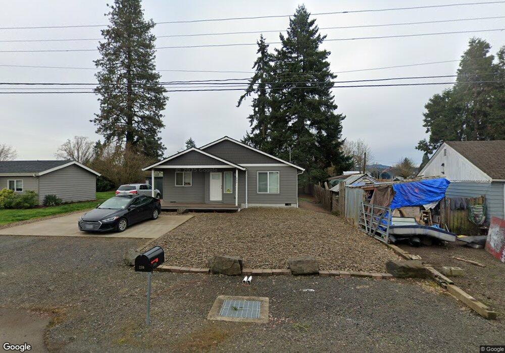
230 Taylor St Lebanon, OR 97355
Estimated Value: $279,000 - $307,763
2
Beds
1
Bath
874
Sq Ft
$336/Sq Ft
Est. Value
About This Home
This home is located at 230 Taylor St, Lebanon, OR 97355 and is currently estimated at $293,382, approximately $335 per square foot. 230 Taylor St is a home located in Linn County with nearby schools including Riverview School, Seven Oak Middle School, and Lebanon High School.
Ownership History
Date
Name
Owned For
Owner Type
Purchase Details
Closed on
Jun 30, 2020
Sold by
Pacific Sky Northwest Llc
Bought by
Western Sky Holdings Llc
Current Estimated Value
Home Financials for this Owner
Home Financials are based on the most recent Mortgage that was taken out on this home.
Original Mortgage
$300,000
Outstanding Balance
$266,514
Interest Rate
3.2%
Mortgage Type
Commercial
Estimated Equity
$26,868
Purchase Details
Closed on
Jan 13, 2017
Sold by
Stuart Annette C
Bought by
Western Holdings Llc
Purchase Details
Closed on
Nov 14, 2016
Sold by
Salisbury Todd
Bought by
Stuart Annette C and Estate Of Elmer J Duncan
Create a Home Valuation Report for This Property
The Home Valuation Report is an in-depth analysis detailing your home's value as well as a comparison with similar homes in the area
Home Values in the Area
Average Home Value in this Area
Purchase History
| Date | Buyer | Sale Price | Title Company |
|---|---|---|---|
| Western Sky Holdings Llc | -- | First American | |
| Western Holdings Llc | $95,000 | First American Title | |
| Western Holdings Llc | $95,000 | First American Title | |
| Stuart Annette C | -- | First American Title |
Source: Public Records
Mortgage History
| Date | Status | Borrower | Loan Amount |
|---|---|---|---|
| Open | Western Sky Holdings Llc | $300,000 |
Source: Public Records
Tax History Compared to Growth
Tax History
| Year | Tax Paid | Tax Assessment Tax Assessment Total Assessment is a certain percentage of the fair market value that is determined by local assessors to be the total taxable value of land and additions on the property. | Land | Improvement |
|---|---|---|---|---|
| 2024 | $1,778 | $120,810 | -- | -- |
| 2023 | $1,726 | $117,300 | $0 | $0 |
| 2022 | $1,690 | $113,890 | $0 | $0 |
| 2021 | $1,618 | $110,580 | $0 | $0 |
| 2020 | $1,585 | $107,360 | $0 | $0 |
| 2019 | $1,545 | $104,240 | $0 | $0 |
| 2018 | $232 | $15,610 | $0 | $0 |
| 2017 | $231 | $15,410 | $0 | $0 |
| 2016 | $226 | $14,970 | $0 | $0 |
| 2015 | $218 | $14,540 | $0 | $0 |
| 2014 | $213 | $14,120 | $0 | $0 |
Source: Public Records
Map
Nearby Homes
- 2187 Mill St
- 2464 Primrose St
- 2101 Primrose St
- 301 Russell St
- 300 Water's Edge Ct
- 0 S Santiam (Lot Unit 102) Hwy
- 2100 Park Dr
- 357 Water's Edge Ct
- 24 E Pine St
- 200 Market (#291) St Unit 291
- 200 Market (#289) St Unit 289
- 371 Lydia Ln
- 200 Market St Unit 221 St
- 200 Market St Unit 222 St
- 200 Market St Unit 218 St
- 200 Market St Unit 255
- 200 Market St Unit 291
- 1800 S 2nd St
- 270 Hobbs St
- 2796 S Main (#26) Rd Unit 26