
Seller's Agent in 2025
Rene Rodriguez
Cabot & Company
(617) 896-5006
2 in this area
44 Total Sales
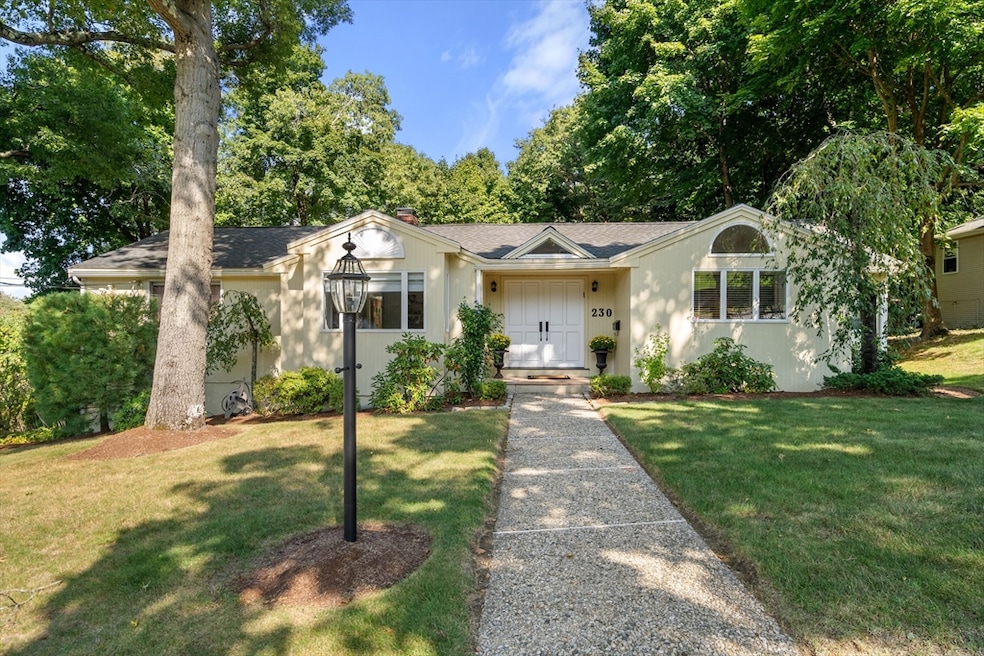


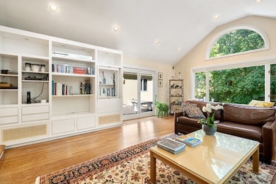

Set on more than 15,000 square feet of private grounds, this 5 bedroom, 4.5 bath home offers a rare blend of space, light, and comfort in the heart of Newton Highlands.The welcoming floor plan includes a formal living room, formal dining room, and a sun-filled family room with skylights, which opens directly to an oversized deck, ideal for dining al fresco and overlooking the expansive backyard — one of the largest in the neighborhood. There is an eat-in kitchen with windows on two sides, stainless steel appliances, and double ovens.Upstairs, generously sized bedrooms provide comfort and privacy, while central air ensures year-round convenience. With two-car garage parking, hardwood floors throughout, and thoughtful updates, this home is designed for both everyday living and entertaining. Located moments from Newton Highlands shops, restaurants, schools, and the T, this property combines tranquility with urban convenience. A rare, large private lot, in this coveted neighborhood.
| Date | Type | Sale Price | Title Company |
|---|---|---|---|
| Quit Claim Deed | $1,830,000 | -- | |
| Quit Claim Deed | -- | None Available | |
| Land Court Massachusetts | $670,000 | -- |
| Date | Status | Loan Amount | Loan Type |
|---|---|---|---|
| Open | $500,000 | New Conventional |
| Date | Event | Price | List to Sale | Price per Sq Ft |
|---|---|---|---|---|
| 11/07/2025 11/07/25 | Sold | $1,830,000 | -3.7% | $425 / Sq Ft |
| 09/18/2025 09/18/25 | Pending | -- | -- | -- |
| 09/03/2025 09/03/25 | For Sale | $1,900,000 | -- | $442 / Sq Ft |
| Year | Tax Paid | Tax Assessment Tax Assessment Total Assessment is a certain percentage of the fair market value that is determined by local assessors to be the total taxable value of land and additions on the property. | Land | Improvement |
|---|---|---|---|---|
| 2025 | $17,077 | $1,742,600 | $1,167,600 | $575,000 |
| 2024 | $16,512 | $1,691,800 | $1,133,600 | $558,200 |
| 2023 | $15,941 | $1,565,900 | $889,300 | $676,600 |
| 2022 | $15,253 | $1,449,900 | $823,400 | $626,500 |
| 2021 | $14,718 | $1,367,800 | $776,800 | $591,000 |
| 2020 | $14,280 | $1,367,800 | $776,800 | $591,000 |
| 2019 | $13,878 | $1,328,000 | $754,200 | $573,800 |
| 2018 | $13,453 | $1,243,300 | $685,500 | $557,800 |
| 2017 | $13,043 | $1,172,900 | $646,700 | $526,200 |
| 2016 | $12,475 | $1,096,200 | $604,400 | $491,800 |
| 2015 | $11,894 | $1,024,500 | $564,900 | $459,600 |
Seller's Agent in 2025
Rene Rodriguez
Cabot & Company
(617) 896-5006
2 in this area
44 Total Sales
Buyer's Agent in 2025
The Drucker Group
Compass
(202) 957-5546
5 in this area
88 Total Sales
Source: MLS Property Information Network (MLS PIN)
MLS Number: 73424773
APN: NEWT-000083-000021-000014
Disclaimer: Certain information contained herein is derived from information provided by parties other than Homes.com. All information provided is deemed reliable, but is not guaranteed to be accurate and should be independently verified.
![]() The property listing data and information, or the Images, set forth herein were provided to MLS Property Information Network, Inc. from third party sources, including sellers, lessors and public records, and were compiled by MLS Property Information Network, Inc. The property listing data and information, and the Images, are for the personal, non-commercial use of consumers having a good faith interest in purchasing or leasing listed properties of the type displayed to them and may not be used for any purpose other than to identify prospective properties which such consumers may have a good faith interest in purchasing or leasing. MLS Property Information Network, Inc. and its subscribers disclaim any and all representations and warranties as to the accuracy of the property listing data and information, or as to the accuracy of any of the Images, set forth herein.
The property listing data and information, or the Images, set forth herein were provided to MLS Property Information Network, Inc. from third party sources, including sellers, lessors and public records, and were compiled by MLS Property Information Network, Inc. The property listing data and information, and the Images, are for the personal, non-commercial use of consumers having a good faith interest in purchasing or leasing listed properties of the type displayed to them and may not be used for any purpose other than to identify prospective properties which such consumers may have a good faith interest in purchasing or leasing. MLS Property Information Network, Inc. and its subscribers disclaim any and all representations and warranties as to the accuracy of the property listing data and information, or as to the accuracy of any of the Images, set forth herein.