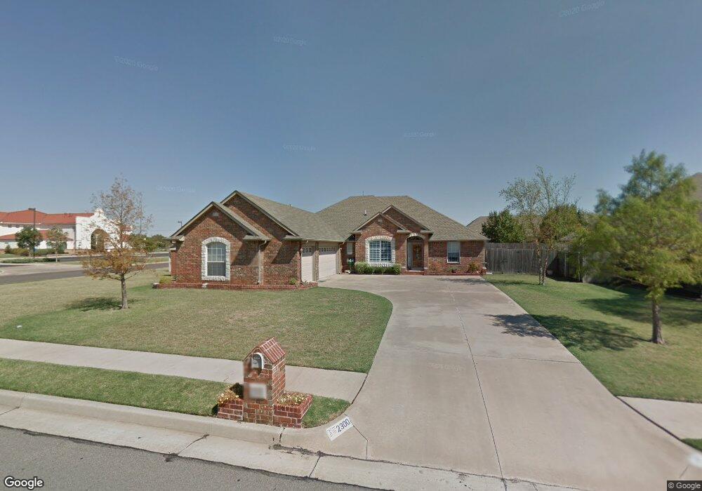
2300 Richland Dr Edmond, OK 73012
Homestead NeighborhoodEstimated Value: $336,338 - $362,000
4
Beds
3
Baths
2,241
Sq Ft
$156/Sq Ft
Est. Value
About This Home
This home is located at 2300 Richland Dr, Edmond, OK 73012 and is currently estimated at $350,085, approximately $156 per square foot. 2300 Richland Dr is a home located in Oklahoma County with nearby schools including Frontier Elementary, Cheyenne Middle School, and North High School.
Ownership History
Date
Name
Owned For
Owner Type
Purchase Details
Closed on
Mar 24, 2003
Sold by
Livingston Bennie V and Livingston Barbara E
Bought by
Livingston Bennie V and Livingston Barbara E
Current Estimated Value
Purchase Details
Closed on
Feb 5, 2002
Sold by
Livingston Bennie V and Livingston Barbara E
Bought by
Livingston Family Revocable Trust
Purchase Details
Closed on
Dec 27, 2000
Sold by
Corbyn Roberts Homes Inc
Bought by
Livingston Bennie V and Livingston Barbara E
Create a Home Valuation Report for This Property
The Home Valuation Report is an in-depth analysis detailing your home's value as well as a comparison with similar homes in the area
Home Values in the Area
Average Home Value in this Area
Purchase History
| Date | Buyer | Sale Price | Title Company |
|---|---|---|---|
| Livingston Bennie V | -- | Oklahoma City Abstract & Tit | |
| Livingston Family Revocable Trust | -- | -- | |
| Livingston Bennie V | $173,000 | First Amer Title & Trust Co |
Source: Public Records
Tax History Compared to Growth
Tax History
| Year | Tax Paid | Tax Assessment Tax Assessment Total Assessment is a certain percentage of the fair market value that is determined by local assessors to be the total taxable value of land and additions on the property. | Land | Improvement |
|---|---|---|---|---|
| 2024 | $2,834 | $29,031 | $4,137 | $24,894 |
| 2023 | $2,834 | $28,185 | $4,223 | $23,962 |
| 2022 | $2,759 | $27,365 | $4,729 | $22,636 |
| 2021 | $2,663 | $26,568 | $5,111 | $21,457 |
| 2020 | $2,614 | $25,795 | $5,212 | $20,583 |
| 2019 | $2,568 | $25,245 | $5,212 | $20,033 |
| 2018 | $2,554 | $24,970 | $0 | $0 |
| 2017 | $2,635 | $25,849 | $5,212 | $20,637 |
| 2016 | $2,624 | $25,794 | $4,463 | $21,331 |
| 2015 | $2,545 | $25,079 | $4,330 | $20,749 |
| 2014 | $2,465 | $24,348 | $4,392 | $19,956 |
Source: Public Records
Map
Nearby Homes
- 2324 Merlot Ct
- 2424 Semillon Way
- 1233 Bradford Place
- 1212 Pine Valley
- 2817 Natchez Trail
- 2605 Jills Trail
- 1812 Natchez Rd
- 2904 Canton Ln
- 2713 Jills Trail
- 900 Woodhollow Trail
- 1712 Victoria Dr
- 604 NW 197th St
- 1801 Del Simmons Dr
- 1717 Park View Place
- 2204 Pine View Terrace
- 2020 Pine View Terrace
- 900 Blue Ridge Dr
- 2321 Santa fe Cir
- 1716 Glacier Ln
- 781 N Santa fe Ave
- 2308 Richland Dr
- 2316 Richland Dr
- 2301 Richland Dr
- 2309 Richland Dr
- 2317 Richland Dr
- 2400 Richland Dr
- 2400 Auburn Ct
- 2401 Richland Dr
- 2408 Auburn Ct
- 2408 Richland Dr
- 1700 Tifton Dr
- 2409 Richland Dr
- 1704 Tifton Dr
- 2501 Auburn Ct
- 2308 Brenton Dr
- 2500 Auburn Ct
- 1708 Tifton Dr
- 2416 Richland Dr
- 2417 Richland Dr
- 2509 Auburn Ct