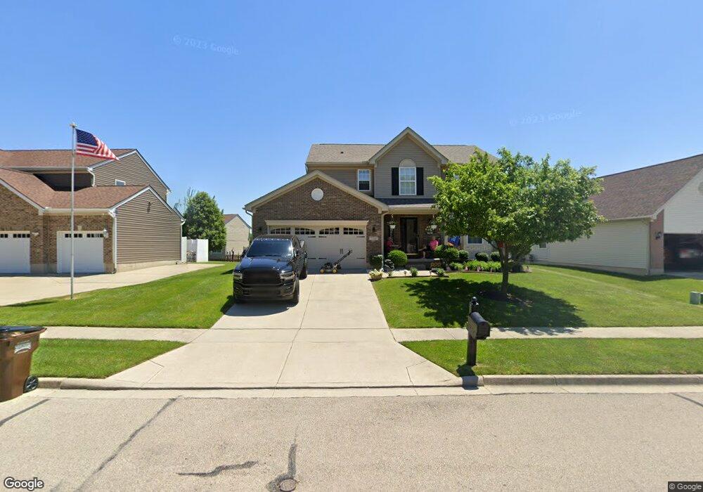
2300 Weston Dr Fairborn, OH 45324
Estimated Value: $340,050 - $381,000
4
Beds
3
Baths
2,020
Sq Ft
$179/Sq Ft
Est. Value
About This Home
This home is located at 2300 Weston Dr, Fairborn, OH 45324 and is currently estimated at $361,763, approximately $179 per square foot. 2300 Weston Dr is a home located in Greene County with nearby schools including Fairborn Primary School, Fairborn Intermediate School, and Fairborn Middle School.
Ownership History
Date
Name
Owned For
Owner Type
Purchase Details
Closed on
May 1, 2023
Sold by
Stinson Jackie S and Crosby Donald T
Bought by
Crosby Jackie S and Crosby Donald T
Current Estimated Value
Purchase Details
Closed on
Jul 21, 2006
Sold by
Inverness Group Inc
Bought by
Stinson Jackie S
Purchase Details
Closed on
Apr 21, 2006
Sold by
Hills Land & Development Co
Bought by
Inverness Group Inc
Home Financials for this Owner
Home Financials are based on the most recent Mortgage that was taken out on this home.
Original Mortgage
$15,000,000
Interest Rate
6.56%
Mortgage Type
Unknown
Create a Home Valuation Report for This Property
The Home Valuation Report is an in-depth analysis detailing your home's value as well as a comparison with similar homes in the area
Home Values in the Area
Average Home Value in this Area
Purchase History
| Date | Buyer | Sale Price | Title Company |
|---|---|---|---|
| Crosby Jackie S | -- | None Listed On Document | |
| Stinson Jackie S | $196,200 | None Available | |
| Inverness Group Inc | $33,400 | None Available |
Source: Public Records
Mortgage History
| Date | Status | Borrower | Loan Amount |
|---|---|---|---|
| Previous Owner | Inverness Group Inc | $15,000,000 |
Source: Public Records
Tax History
| Year | Tax Paid | Tax Assessment Tax Assessment Total Assessment is a certain percentage of the fair market value that is determined by local assessors to be the total taxable value of land and additions on the property. | Land | Improvement |
|---|---|---|---|---|
| 2025 | $4,521 | $95,940 | $16,150 | $79,790 |
| 2024 | $4,595 | $95,940 | $16,150 | $79,790 |
| 2023 | $4,595 | $95,940 | $16,150 | $79,790 |
| 2022 | $4,030 | $71,410 | $13,450 | $57,960 |
| 2021 | $4,091 | $71,410 | $13,450 | $57,960 |
| 2020 | $4,114 | $71,410 | $13,450 | $57,960 |
| 2019 | $3,512 | $60,960 | $11,080 | $49,880 |
| 2018 | $3,552 | $60,960 | $11,080 | $49,880 |
| 2017 | $3,516 | $60,960 | $11,080 | $49,880 |
| 2016 | $3,517 | $60,250 | $11,080 | $49,170 |
| 2015 | $3,354 | $60,250 | $11,080 | $49,170 |
| 2014 | $3,247 | $60,250 | $11,080 | $49,170 |
Source: Public Records
Map
Nearby Homes
- 1200 Whitetail Dr
- 1121 Whitetail Dr
- 1105 Windsong Trail
- 2549 Fawn Dr
- 1840 Spring Ridge Ct
- 00 Trebein Rd
- 1010 Brehm Blvd
- 1788 Fawnwood Ct
- Lot 1 Trebein Rd
- 1494 Indigo Dr
- 1183 Brehm Blvd
- 1155 Elloway Place
- 1634 Arden Bend
- 630 Hidden Valley Ct
- 1622 Arden Bend
- 479 Park Hills Crossing
- 474 Kalynn Cir
- 474 Kalynn Cir Unit 19
- 482 Kalynn Cir Unit 18
- 444 Park Hills Crossing Unit 54
- 2308 Weston Dr
- 2294 Weston Dr
- 1480 Hansen Ct
- 2288 Weston Dr
- 2316 Weston Dr
- 1477 Hansen Ct
- 2303 Weston Dr
- 2295 Weston Dr
- 2311 Weston Dr
- 2280 Weston Dr
- 1463 Observatory Dr
- 2289 Weston Dr
- 1471 Observatory Dr
- 1455 Observatory Dr
- 2317 Weston Dr
- 1483 Hansen Ct
- 1479 Observatory Dr
- 1449 Observatory Dr
- 2283 Weston Dr
- 2325 Weston Dr
Your Personal Tour Guide
Ask me questions while you tour the home.