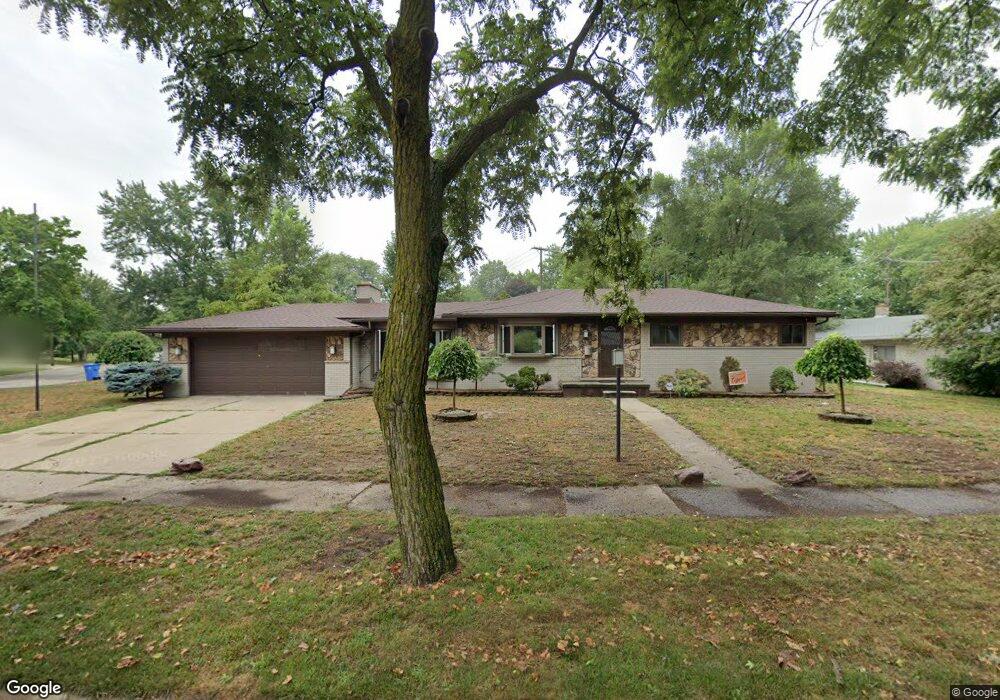
23019 N Brookside Dr Dearborn Heights, MI 48125
Estimated Value: $243,000 - $260,000
3
Beds
3
Baths
1,442
Sq Ft
$176/Sq Ft
Est. Value
About This Home
This home is located at 23019 N Brookside Dr, Dearborn Heights, MI 48125 and is currently estimated at $253,249, approximately $175 per square foot. 23019 N Brookside Dr is a home located in Wayne County with nearby schools including Polk Elementary School, Bedford School, and Pardee School.
Ownership History
Date
Name
Owned For
Owner Type
Purchase Details
Closed on
Sep 10, 2004
Sold by
Zamora Lorena A
Bought by
Moore Edward
Current Estimated Value
Purchase Details
Closed on
Jun 23, 2004
Sold by
Macias Jesus Jose and Zamora Lorena A
Bought by
Countrywide Home Loans Inc
Purchase Details
Closed on
Aug 29, 2003
Sold by
Bazzi Saber and Bazzi Rima
Bought by
Macias Jesus Jose
Purchase Details
Closed on
Aug 12, 1999
Sold by
Phelps Diane I Gary K
Bought by
Bazzi Saber
Create a Home Valuation Report for This Property
The Home Valuation Report is an in-depth analysis detailing your home's value as well as a comparison with similar homes in the area
Home Values in the Area
Average Home Value in this Area
Purchase History
| Date | Buyer | Sale Price | Title Company |
|---|---|---|---|
| Moore Edward | $165,000 | Multiple | |
| Countrywide Home Loans Inc | $117,900 | -- | |
| Macias Jesus Jose | $178,000 | Multiple | |
| Bazzi Saber | $140,000 | -- |
Source: Public Records
Tax History Compared to Growth
Tax History
| Year | Tax Paid | Tax Assessment Tax Assessment Total Assessment is a certain percentage of the fair market value that is determined by local assessors to be the total taxable value of land and additions on the property. | Land | Improvement |
|---|---|---|---|---|
| 2025 | $2,582 | $135,700 | $0 | $0 |
| 2024 | $2,582 | $128,800 | $0 | $0 |
| 2023 | $2,440 | $113,400 | $0 | $0 |
| 2022 | $3,387 | $102,400 | $0 | $0 |
| 2021 | $3,388 | $96,400 | $0 | $0 |
| 2019 | $3,290 | $78,100 | $0 | $0 |
| 2018 | $2,211 | $66,400 | $0 | $0 |
| 2017 | $1,990 | $62,600 | $0 | $0 |
| 2016 | $3,131 | $60,000 | $0 | $0 |
| 2015 | $5,600 | $56,000 | $0 | $0 |
| 2013 | $5,970 | $61,100 | $0 | $0 |
| 2010 | -- | $73,600 | $0 | $0 |
Source: Public Records
Map
Nearby Homes
- 23214 S Brookside Dr
- 22453 Pardee Ct
- 000 Hanover St
- 4943 Pardee Ave
- 5015 Lincoln Blvd
- 4459 Parker St
- 4665 Lincoln Blvd
- 5671 Syracuse St
- 4665 Syracuse St
- 4449 Academy St
- 4901 Cornell St
- 5689 Cornell St
- 4209 Vassar St
- 5908 Pine St
- 4506 Syracuse St
- 4442 Mckinley St
- 5656 Monroe St
- 4474 Syracuse St
- 5954 Pine St
- 5614 Katherine St
- 23043 N Brookside Dr
- 5422 Eden Dr
- 5443 Heather Ln
- 5434 Eden Dr
- 5455 Heather Ln
- 5425 Heather Ln
- 5446 Eden Dr
- 5467 Heather Ln
- 5458 Eden Dr
- 5479 Heather Ln
- 23036 N Brookside Dr
- 23012 N Brookside Dr
- 5444 Heather Ln
- 5432 Heather Ln
- 5456 Heather Ln
- 23211 N Brookside Dr
- 0 N Brookside Dr
- 5468 Heather Ln
- 5470 Eden Dr
- 5491 Heather Ln