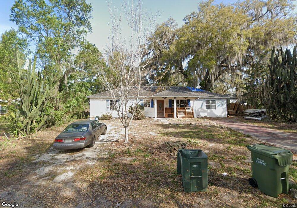
2302 Vine St Leesburg, FL 34748
Estimated Value: $122,000 - $188,000
2
Beds
2
Baths
1,008
Sq Ft
$165/Sq Ft
Est. Value
About This Home
This home is located at 2302 Vine St, Leesburg, FL 34748 and is currently estimated at $166,342, approximately $165 per square foot. 2302 Vine St is a home located in Lake County with nearby schools including Leesburg Elementary School, Oak Park Middle School, and Leesburg High School.
Ownership History
Date
Name
Owned For
Owner Type
Purchase Details
Closed on
Apr 16, 2024
Sold by
Fodrie Frank
Bought by
Robin Gail And Frank Fodrie Land Trust and Martin
Current Estimated Value
Purchase Details
Closed on
Jul 25, 2002
Sold by
Fodrie Frankie C
Bought by
Ford Robbie Gail
Purchase Details
Closed on
Oct 7, 1998
Sold by
Ford Robbie Gail
Bought by
Fodrie Frankie C
Home Financials for this Owner
Home Financials are based on the most recent Mortgage that was taken out on this home.
Original Mortgage
$57,600
Interest Rate
6.76%
Create a Home Valuation Report for This Property
The Home Valuation Report is an in-depth analysis detailing your home's value as well as a comparison with similar homes in the area
Home Values in the Area
Average Home Value in this Area
Purchase History
| Date | Buyer | Sale Price | Title Company |
|---|---|---|---|
| Robin Gail And Frank Fodrie Land Trust | $123,900 | Clear Title Solutions | |
| Ford Robbie Gail | -- | -- | |
| Fodrie Frankie C | $70,000 | -- |
Source: Public Records
Mortgage History
| Date | Status | Borrower | Loan Amount |
|---|---|---|---|
| Previous Owner | Fodrie Frankie C | $57,600 |
Source: Public Records
Tax History Compared to Growth
Tax History
| Year | Tax Paid | Tax Assessment Tax Assessment Total Assessment is a certain percentage of the fair market value that is determined by local assessors to be the total taxable value of land and additions on the property. | Land | Improvement |
|---|---|---|---|---|
| 2025 | $659 | $152,939 | $59,833 | $93,106 |
| 2024 | $659 | $69,570 | -- | -- |
| 2023 | $659 | $65,590 | $0 | $0 |
| 2022 | $594 | $63,680 | $0 | $0 |
| 2021 | $584 | $61,825 | $0 | $0 |
| 2020 | $607 | $60,972 | $0 | $0 |
| 2019 | $583 | $59,602 | $0 | $0 |
| 2018 | $564 | $58,491 | $0 | $0 |
| 2017 | $559 | $57,288 | $0 | $0 |
| 2016 | $561 | $56,110 | $0 | $0 |
| 2015 | $573 | $55,720 | $0 | $0 |
| 2014 | $517 | $55,278 | $0 | $0 |
Source: Public Records
Map
Nearby Homes
- 2200 Butler St
- 206 Cooke St
- 2013 Vine St
- 0 Thomas Ave Unit MFRG5084639
- 405 Louis St
- 2419 W Main St
- 2004 High St
- 2507 Tecumseh Ave
- 108 N Truett St
- 0 W Main 2010 High St Unit G5052467
- 710 Scenic St
- 710 Carriage Ln
- 2008 Hollywood Dr
- 2338 Conestoga Dr
- 708 Coachman Dr
- 104 N Chester St
- 508 Alexander Rd
- 107 N Oakland St
- 109 N Oakland St
- 811 S Lone Oak Dr