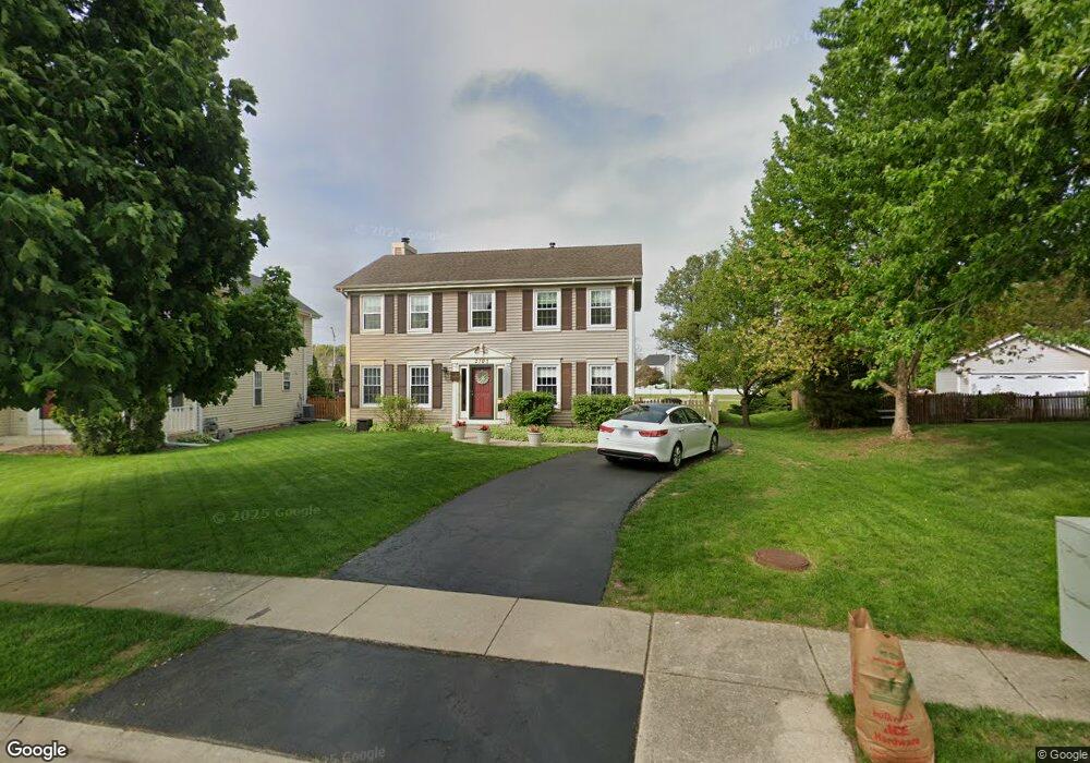
2303 Riverside Dr Plainfield, IL 60586
Fall Creek NeighborhoodEstimated Value: $367,000 - $387,000
Studio
1
Bath
1,896
Sq Ft
$198/Sq Ft
Est. Value
About This Home
This home is located at 2303 Riverside Dr, Plainfield, IL 60586 and is currently estimated at $376,286, approximately $198 per square foot. 2303 Riverside Dr is a home located in Will County with nearby schools including River View Elementary School, Timber Ridge Middle School, and Plainfield Central High School.
Ownership History
Date
Name
Owned For
Owner Type
Purchase Details
Closed on
Mar 5, 2025
Sold by
Wiesbrook William R and Wiesbrook Colleen M
Bought by
Wiesbrook Family Land Trust
Current Estimated Value
Purchase Details
Closed on
Dec 14, 2001
Sold by
Wiesbrook William R
Bought by
Wiesbrook William R and Wiesbrook Colleen M
Purchase Details
Closed on
Mar 30, 1998
Sold by
American National Bk & Tr Co Of Chicago
Bought by
Wiesbrook William R
Home Financials for this Owner
Home Financials are based on the most recent Mortgage that was taken out on this home.
Original Mortgage
$124,000
Interest Rate
7.09%
Create a Home Valuation Report for This Property
The Home Valuation Report is an in-depth analysis detailing your home's value as well as a comparison with similar homes in the area
Home Values in the Area
Average Home Value in this Area
Purchase History
| Date | Buyer | Sale Price | Title Company |
|---|---|---|---|
| Wiesbrook Family Land Trust | -- | None Listed On Document | |
| Wiesbrook William R | -- | -- | |
| Wiesbrook William R | $155,000 | -- |
Source: Public Records
Mortgage History
| Date | Status | Borrower | Loan Amount |
|---|---|---|---|
| Previous Owner | Wiesbrook William R | $124,000 |
Source: Public Records
Tax History
| Year | Tax Paid | Tax Assessment Tax Assessment Total Assessment is a certain percentage of the fair market value that is determined by local assessors to be the total taxable value of land and additions on the property. | Land | Improvement |
|---|---|---|---|---|
| 2024 | $7,594 | $114,032 | $26,471 | $87,561 |
| 2023 | $7,263 | $102,991 | $23,908 | $79,083 |
| 2022 | $7,263 | $92,500 | $21,473 | $71,027 |
| 2021 | $6,439 | $86,448 | $20,068 | $66,380 |
| 2020 | $6,341 | $83,996 | $19,499 | $64,497 |
| 2019 | $6,118 | $80,034 | $18,579 | $61,455 |
| 2018 | $5,854 | $75,197 | $17,456 | $57,741 |
| 2017 | $5,678 | $71,459 | $16,588 | $54,871 |
| 2016 | $5,561 | $68,154 | $15,821 | $52,333 |
| 2015 | $5,185 | $63,845 | $14,821 | $49,024 |
| 2014 | $5,185 | $61,591 | $14,298 | $47,293 |
| 2013 | $5,185 | $61,591 | $14,298 | $47,293 |
Source: Public Records
Map
Nearby Homes
- 3040 Abbey Cir
- 3020 Abbey Cir
- 3005 Abbey Cir
- 4755 Pratt Ct
- 2350 Woodhill Ct
- 2173 Dalewood Ct Unit 3
- 2218 Dalewood Ct
- 4757 Foster Ct Unit 3
- 2010 Primrose Dr
- 1909 Prairie Trail Ct
- 4013 Oak Tree Ln
- 5005 Inverness Cir
- 4303 Anthony Ln
- 4511 Skylark Ln
- 4513 Skylark Ln
- 2019 Gleneagle Dr
- 3716 Fiday Rd
- 1511 Thornwood Ln
- 3100 Jo Ann Dr
- 2512 Lockner Blvd
- 2301 Riverside Dr
- 4418 Old Meadow Ct
- 4420 Old Meadow Ct
- 2229 Riverside Dr Unit 1
- 2227 Riverside Dr
- 2304 Riverside Dr Unit 1
- 4422 Old Meadow Ct
- 2302 Riverside Dr
- 2306 Riverside Dr
- 2225 Riverside Dr
- 2221 Honeywood Ct
- 2308 Riverside Dr Unit 1
- 4424 Old Meadow Ct Unit 1
- 4419 Old Meadow Ct
- 2223 Riverside Dr
- 4421 Old Meadow Ct
- 2223 Honeywood Ct
- 2310 Riverside Dr
- 4425 Old Meadow Ct
- 4423 Old Meadow Ct
Your Personal Tour Guide
Ask me questions while you tour the home.