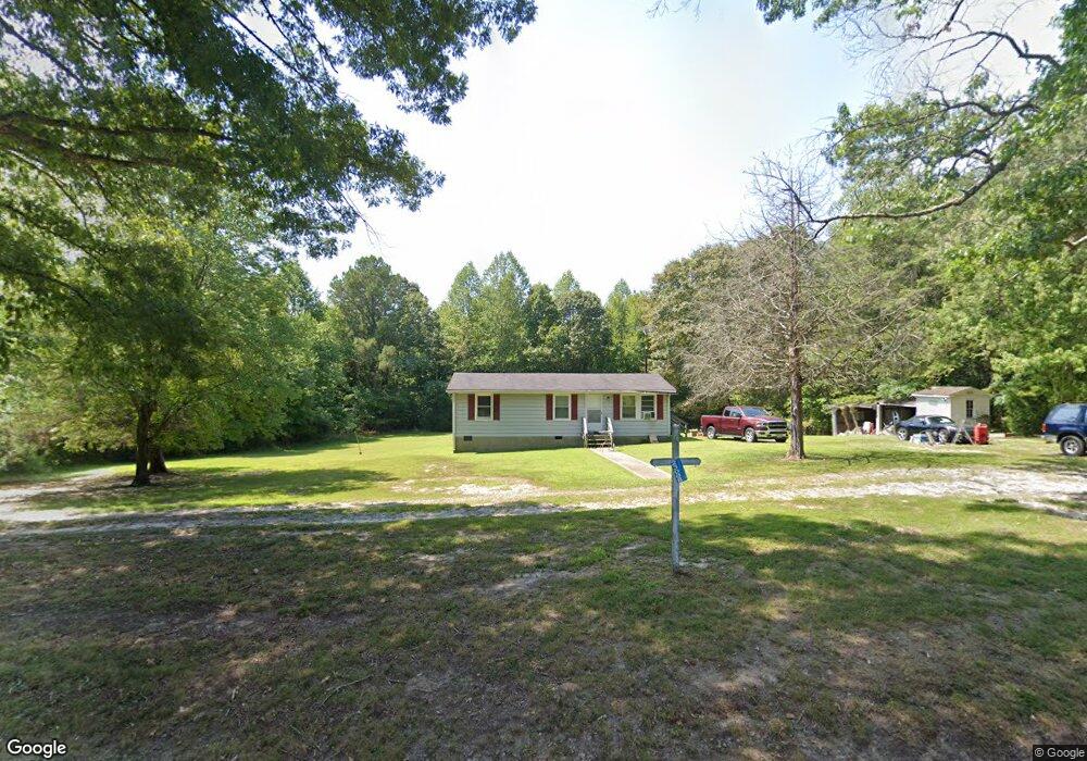
23088 File Rd Bowling Green, VA 22427
Estimated Value: $225,986 - $283,000
3
Beds
1
Bath
--
Sq Ft
1.01
Acres
About This Home
This home is located at 23088 File Rd, Bowling Green, VA 22427 and is currently estimated at $253,997. 23088 File Rd is a home located in Caroline County with nearby schools including Caroline Middle School and Caroline High School.
Ownership History
Date
Name
Owned For
Owner Type
Purchase Details
Closed on
Aug 18, 2010
Sold by
Sanford Paul
Bought by
Sanford Paul and Sanford Brenda B
Current Estimated Value
Purchase Details
Closed on
Aug 9, 2010
Sold by
Federal National Mortgage Association
Bought by
Sanford Paul
Purchase Details
Closed on
Mar 12, 2010
Sold by
Madsen Christopher M and Lentz Adam A
Bought by
Federal National Mortgage Association
Purchase Details
Closed on
Aug 14, 2007
Sold by
Stover Linda S
Bought by
Madsen Christopher M
Home Financials for this Owner
Home Financials are based on the most recent Mortgage that was taken out on this home.
Original Mortgage
$128,800
Interest Rate
6.12%
Mortgage Type
New Conventional
Create a Home Valuation Report for This Property
The Home Valuation Report is an in-depth analysis detailing your home's value as well as a comparison with similar homes in the area
Home Values in the Area
Average Home Value in this Area
Purchase History
| Date | Buyer | Sale Price | Title Company |
|---|---|---|---|
| Sanford Paul | -- | Hanover Title & Settlement S | |
| Sanford Paul | $58,540 | Hanover Title & Settlement S | |
| Federal National Mortgage Association | $160,855 | None Available | |
| Madsen Christopher M | $161,000 | -- |
Source: Public Records
Mortgage History
| Date | Status | Borrower | Loan Amount |
|---|---|---|---|
| Previous Owner | Madsen Christopher M | $128,800 | |
| Previous Owner | Madsen Christopher M | $32,200 |
Source: Public Records
Tax History Compared to Growth
Tax History
| Year | Tax Paid | Tax Assessment Tax Assessment Total Assessment is a certain percentage of the fair market value that is determined by local assessors to be the total taxable value of land and additions on the property. | Land | Improvement |
|---|---|---|---|---|
| 2025 | $157,388 | $204,400 | $45,100 | $159,300 |
| 2024 | $843 | $109,500 | $47,000 | $62,500 |
| 2023 | $843 | $109,500 | $47,000 | $62,500 |
| 2022 | $843 | $109,500 | $47,000 | $62,500 |
| 2021 | $843 | $109,500 | $47,000 | $62,500 |
| 2020 | $735 | $88,600 | $31,000 | $57,600 |
| 2019 | $735 | $88,600 | $31,000 | $57,600 |
| 2018 | $735 | $88,600 | $31,000 | $57,600 |
| 2017 | $735 | $88,600 | $31,000 | $57,600 |
| 2016 | $727 | $88,600 | $31,000 | $57,600 |
| 2015 | $630 | $87,500 | $31,000 | $56,500 |
| 2014 | $630 | $87,500 | $31,000 | $56,500 |
Source: Public Records
Map
Nearby Homes
- 23390 Mt Cloud Rd
- 0 File Rd Unit VACV2008800
- 23094 Mattaponi Trail
- 0 Sparta Rd Unit VACV2008914
- 20105 Sparta Rd
- 000 Locust Hill Rd
- 13677 Newtown Rd
- 19370 Alps Dr
- 0 Mattaponi Trail Unit VACV2008590
- 0 Mattaponi Trail Unit VACV2007584
- 18056 Obrien Ct
- 0 S Main St Unit 2520156
- 897 Salvia Rd
- 878 Salvia Rd
- 11125 Newtown Rd
- 3693 Byrd's Mill Rd
- 5515 Herring Creek Rd
- 29315 Sparta Rd
- 23RA Vessels Rd
- 547 Dover Ln
- 23107 File Rd
- 23048 File Rd
- 23093 File Rd
- 23026 File Rd
- 23125 File Rd
- 23147 File Rd
- 22670 File Rd
- 22652 File Rd
- 23218 File Rd
- 23247 File Rd
- 0 File Rd
- 22564 File Rd
- 17081 Rollins Rd
- 17045 Rollins Rd
- 17030 Brookwood Dr
- TBD Lot 125 Rollins Rd
- 17024 Brookwood Dr
- TBD Lot 128 Rollins Rd
- 17018 Brookwood Dr
- 17012 Brookwood Dr