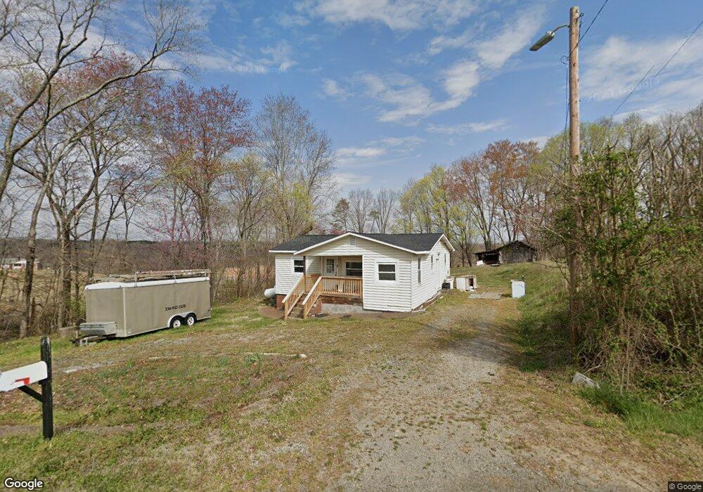
231 Alee Rd Reidsville, NC 27320
Estimated Value: $98,000 - $121,000
--
Bed
--
Bath
792
Sq Ft
$140/Sq Ft
Est. Value
About This Home
This home is located at 231 Alee Rd, Reidsville, NC 27320 and is currently estimated at $110,801, approximately $139 per square foot. 231 Alee Rd is a home located in Rockingham County with nearby schools including Williamsburg Elementary School, Reidsville High School, and Reidsville Middle School.
Ownership History
Date
Name
Owned For
Owner Type
Purchase Details
Closed on
Feb 13, 2025
Sold by
Corum Peyton S and Brown Joshua D
Bought by
Hall Abigail Madison
Current Estimated Value
Home Financials for this Owner
Home Financials are based on the most recent Mortgage that was taken out on this home.
Original Mortgage
$113,000
Outstanding Balance
$112,329
Interest Rate
6.91%
Mortgage Type
New Conventional
Estimated Equity
-$1,528
Purchase Details
Closed on
Nov 12, 2021
Sold by
Dickerson Tyron David
Bought by
Corum Peyton S and Browk Joshua D
Home Financials for this Owner
Home Financials are based on the most recent Mortgage that was taken out on this home.
Original Mortgage
$45,600
Interest Rate
3.01%
Mortgage Type
New Conventional
Create a Home Valuation Report for This Property
The Home Valuation Report is an in-depth analysis detailing your home's value as well as a comparison with similar homes in the area
Home Values in the Area
Average Home Value in this Area
Purchase History
| Date | Buyer | Sale Price | Title Company |
|---|---|---|---|
| Hall Abigail Madison | $90,000 | None Listed On Document | |
| Hall Abigail Madison | $90,000 | None Listed On Document | |
| Corum Peyton S | $48,000 | None Available |
Source: Public Records
Mortgage History
| Date | Status | Borrower | Loan Amount |
|---|---|---|---|
| Open | Hall Abigail Madison | $113,000 | |
| Closed | Hall Abigail Madison | $113,000 | |
| Previous Owner | Corum Peyton S | $45,600 |
Source: Public Records
Tax History Compared to Growth
Tax History
| Year | Tax Paid | Tax Assessment Tax Assessment Total Assessment is a certain percentage of the fair market value that is determined by local assessors to be the total taxable value of land and additions on the property. | Land | Improvement |
|---|---|---|---|---|
| 2025 | $686 | $107,063 | $12,076 | $94,987 |
| 2024 | $686 | $107,063 | $12,076 | $94,987 |
| 2023 | $686 | $48,125 | $10,978 | $37,147 |
| 2022 | $378 | $48,125 | $10,978 | $37,147 |
| 2021 | $378 | $48,125 | $10,978 | $37,147 |
| 2020 | $378 | $48,125 | $10,978 | $37,147 |
| 2019 | $378 | $48,125 | $10,978 | $37,147 |
| 2018 | $415 | $52,783 | $20,369 | $32,414 |
| 2017 | $404 | $52,783 | $20,369 | $32,414 |
| 2015 | $408 | $52,783 | $20,369 | $32,414 |
| 2014 | $404 | $52,783 | $20,369 | $32,414 |
Source: Public Records
Map
Nearby Homes
- 219 Cart Dr
- 221 Cart Dr
- 0 Cart Dr
- Lot 6 Cart Dr
- Lot 3 Cart Dr
- Lot 4 Cart Dr
- Lot 5 Cart Dr
- Lot 2 Cart Dr
- 2846 Grooms Rd
- Lot 1 Manley Farm Rd
- 2072 U S 158
- 126 Mullins Rd
- 2053 U S Highway 158 W
- 247 Bobwhite Dr
- 1790 - 1826 U S Highway 158 W
- 1500 Ballymena Dr
- 209 Brooks Rd
- 525 Grooms Rd
- 00 Rolling Meadows Dr
- 0 Adams Rd