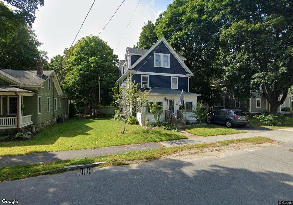
231 Commonwealth Ave Concord, MA 01742
Estimated Value: $617,344 - $848,000
4
Beds
2
Baths
1,622
Sq Ft
$455/Sq Ft
Est. Value
About This Home
This home is located at 231 Commonwealth Ave, Concord, MA 01742 and is currently estimated at $737,836, approximately $454 per square foot. 231 Commonwealth Ave is a home located in Middlesex County with nearby schools including Thoreau Elementary School, Concord Middle School, and Concord Carlisle High School.
Ownership History
Date
Name
Owned For
Owner Type
Purchase Details
Closed on
Apr 29, 1992
Sold by
Dires Jeff and Dries Donald
Bought by
Anderson Gail M
Current Estimated Value
Purchase Details
Closed on
Feb 24, 1989
Sold by
Gerrin Dennis M
Bought by
Dries Jeff
Create a Home Valuation Report for This Property
The Home Valuation Report is an in-depth analysis detailing your home's value as well as a comparison with similar homes in the area
Home Values in the Area
Average Home Value in this Area
Purchase History
| Date | Buyer | Sale Price | Title Company |
|---|---|---|---|
| Anderson Gail M | $140,000 | -- | |
| Anderson Gail M | $140,000 | -- | |
| Dries Jeff | $160,500 | -- |
Source: Public Records
Mortgage History
| Date | Status | Borrower | Loan Amount |
|---|---|---|---|
| Open | Dries Jeff | $213,000 | |
| Closed | Dries Jeff | $200,000 | |
| Closed | Dries Jeff | $100,000 |
Source: Public Records
Tax History
| Year | Tax Paid | Tax Assessment Tax Assessment Total Assessment is a certain percentage of the fair market value that is determined by local assessors to be the total taxable value of land and additions on the property. | Land | Improvement |
|---|---|---|---|---|
| 2025 | $7,356 | $529,200 | $173,800 | $355,400 |
| 2024 | $7,224 | $530,400 | $173,800 | $356,600 |
| 2023 | $6,712 | $467,100 | $186,800 | $280,300 |
| 2022 | $6,269 | $397,500 | $162,500 | $235,000 |
| 2021 | $6,211 | $394,600 | $147,200 | $247,400 |
| 2020 | $6,106 | $371,200 | $129,700 | $241,500 |
| 2019 | $5,618 | $343,600 | $128,500 | $215,100 |
| 2018 | $5,941 | $330,800 | $115,700 | $215,100 |
| 2017 | $5,828 | $325,200 | $108,400 | $216,800 |
| 2016 | $5,777 | $320,400 | $104,000 | $216,400 |
| 2015 | $5,743 | $307,100 | $93,800 | $213,300 |
| 2014 | $5,555 | $292,700 | $89,000 | $203,700 |
Source: Public Records
Map
Nearby Homes
- 42 Sunnyside Ln
- 54 Maple St
- 95 Conant St Unit 320
- 22 Center Village Dr
- 70 McCallar Ln
- 111 Central St
- 53 Prairie St
- 16 Concord Greene Unit 5
- 66 Old Stow Rd
- 79-81 Assabet Ave
- 47 Bridgecourt Ln
- 245 Oak Hill Cir
- 45 Millrun Ln Unit 45
- 20 Westvale Meadows Unit C
- 55 Staffordshire Ln Unit B
- 65 Summit St
- 27 Water St
- 37 Water St
- 60 Lawsbrook Rd
- 100 Harrington Ave
- 225 Commonwealth Ave
- 237 Commonwealth Ave
- 219 Commonwealth Ave
- 21 Commonwealth Ave Unit 21
- 247 Commonwealth Ave
- 247 Commonwealth Ave Unit 247
- 238 Commonwealth Ave Unit 1
- 238 Commonwealth Ave Unit 4
- 238 Commonwealth Ave
- 249 Commonwealth Ave Unit 249
- 226 Commonwealth Ave
- 211 Commonwealth Ave
- 218 Commonwealth Ave
- 246 Commonwealth Ave
- 23 Commonwealth Ave
- 205 Commonwealth Ave
- 257 Commonwealth Ave
- 255 Commonwealth Ave
- 257 Commonwealth Ave Unit 1
- 257 Commonwealth Ave Unit 257
Your Personal Tour Guide
Ask me questions while you tour the home.