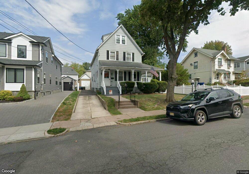
231 Division Ave Hasbrouck Heights, NJ 07604
Estimated Value: $868,000 - $1,115,000
Studio
--
Bath
3,404
Sq Ft
$278/Sq Ft
Est. Value
About This Home
This home is located at 231 Division Ave, Hasbrouck Heights, NJ 07604 and is currently estimated at $945,800, approximately $277 per square foot. 231 Division Ave is a home located in Bergen County with nearby schools including Hasbrouck Heights High School and Corpus Christi School.
Ownership History
Date
Name
Owned For
Owner Type
Purchase Details
Closed on
May 6, 2008
Sold by
Mengel Annette G
Bought by
Blackley Linda and Palazzo Juliet
Current Estimated Value
Purchase Details
Closed on
Feb 8, 2008
Sold by
Dallas Judith M
Bought by
Mengel Theodore H and Mengel Annette G
Create a Home Valuation Report for This Property
The Home Valuation Report is an in-depth analysis detailing your home's value as well as a comparison with similar homes in the area
Home Values in the Area
Average Home Value in this Area
Purchase History
| Date | Buyer | Sale Price | Title Company |
|---|---|---|---|
| Blackley Linda | $525,000 | -- | |
| Mengel Theodore H | -- | -- | |
| Mengel Theodore H | -- | -- |
Source: Public Records
Tax History
| Year | Tax Paid | Tax Assessment Tax Assessment Total Assessment is a certain percentage of the fair market value that is determined by local assessors to be the total taxable value of land and additions on the property. | Land | Improvement |
|---|---|---|---|---|
| 2025 | $16,188 | $633,600 | $241,900 | $391,700 |
| 2024 | $15,676 | $633,600 | $241,900 | $391,700 |
| 2023 | $15,102 | $608,300 | $231,900 | $376,400 |
| 2022 | $15,102 | $561,000 | $211,900 | $349,100 |
| 2021 | $14,338 | $518,500 | $199,400 | $319,100 |
| 2020 | $14,530 | $505,200 | $189,400 | $315,800 |
| 2019 | $14,117 | $496,200 | $186,900 | $309,300 |
| 2018 | $13,784 | $483,300 | $184,400 | $298,900 |
| 2017 | $13,549 | $474,400 | $181,900 | $292,500 |
| 2016 | $13,639 | $449,400 | $171,900 | $277,500 |
| 2015 | $13,419 | $449,400 | $171,900 | $277,500 |
| 2014 | $13,051 | $449,400 | $171,900 | $277,500 |
Source: Public Records
Map
Nearby Homes
- 270 Hamilton Ave
- 221 Passaic Ave
- 125 Henry St
- 417 Franklin Ave
- 145 Cleveland Ave
- 224 Cleveland Ave
- 50 Henry St
- 74 Kipp Ave
- 14 Passaic Ave
- 8800 Boulevard Unit 4B
- 212 Burton Ave
- 14 Jefferson Ave Unit 16
- 183 Terhune Ave Unit 3
- 25 Roosevelt Dr
- 183c Terhune Ave Unit C
- 4 Wesmont Dr Unit 1102
- 309 Ottawa Ave
- 288 Sussex Rd
- 43 Wesmont Dr Unit 1712
- 129 Eisenhower Ln Unit 2109
- 227 Division Ave
- 237 Division Ave
- 230 Walter Ave
- 223 Division Ave
- 234 Walter Ave
- 226 Walter Ave
- 226 Walter Ave Unit 2
- 241 Division Ave
- 238 Walter Ave
- 222 Walter Ave
- 219 Division Ave
- 232 Division Ave
- 228 Division Ave
- 247 Division Ave
- 236 Division Ave
- 218 Walter Ave
- 224 Division Ave
- 244 Walter Ave
- 215 Division Ave
- 240 Division Ave
Your Personal Tour Guide
Ask me questions while you tour the home.