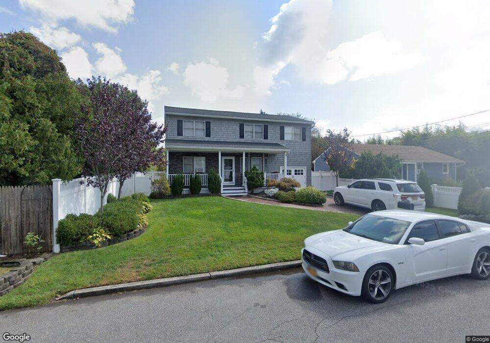
231 Frederick Ave Babylon, NY 11702
Estimated Value: $664,583 - $905,000
Studio
1
Bath
1,980
Sq Ft
$393/Sq Ft
Est. Value
About This Home
This home is located at 231 Frederick Ave, Babylon, NY 11702 and is currently estimated at $777,396, approximately $392 per square foot. 231 Frederick Ave is a home located in Suffolk County with nearby schools including Babylon Elementary School, Babylon Memorial Grade School, and Babylon High School.
Ownership History
Date
Name
Owned For
Owner Type
Purchase Details
Closed on
Jul 21, 2000
Sold by
Don Anthonys Property Management Inc
Bought by
Gilbert Donald D and Gilbert Evelyn
Current Estimated Value
Home Financials for this Owner
Home Financials are based on the most recent Mortgage that was taken out on this home.
Original Mortgage
$252,600
Interest Rate
7.1%
Purchase Details
Closed on
Dec 30, 1999
Sold by
Bordies Vanda and Williams Victoria
Bought by
Don Anthony Property Management Inc
Create a Home Valuation Report for This Property
The Home Valuation Report is an in-depth analysis detailing your home's value as well as a comparison with similar homes in the area
Home Values in the Area
Average Home Value in this Area
Purchase History
| Date | Buyer | Sale Price | Title Company |
|---|---|---|---|
| Gilbert Donald D | $265,900 | Fidelity National Title Ins | |
| Don Anthony Property Management Inc | $70,000 | Fidelity National Title Ins |
Source: Public Records
Mortgage History
| Date | Status | Borrower | Loan Amount |
|---|---|---|---|
| Previous Owner | Gilbert Donald D | $252,600 |
Source: Public Records
Tax History
| Year | Tax Paid | Tax Assessment Tax Assessment Total Assessment is a certain percentage of the fair market value that is determined by local assessors to be the total taxable value of land and additions on the property. | Land | Improvement |
|---|---|---|---|---|
| 2024 | $13,654 | $3,950 | $100 | $3,850 |
| 2023 | $11,961 | $3,950 | $100 | $3,850 |
| 2022 | $10,336 | $3,950 | $100 | $3,850 |
| 2021 | $10,336 | $3,950 | $100 | $3,850 |
| 2020 | $12,557 | $3,950 | $100 | $3,850 |
| 2019 | $12,528 | $0 | $0 | $0 |
| 2018 | $10,394 | $3,950 | $100 | $3,850 |
| 2017 | $10,394 | $3,950 | $100 | $3,850 |
| 2016 | $10,291 | $3,950 | $100 | $3,850 |
| 2015 | -- | $3,950 | $100 | $3,850 |
| 2014 | -- | $3,950 | $100 | $3,850 |
Source: Public Records
Map
Nearby Homes
- 91 Beverly Rd
- 188 Ralph Ave
- 104 Hawthorne Ave
- 79 Woodrow Pkwy
- 104 Frederick Ave
- 154A Woodrow Pkwy
- 359 Park Ave
- 234 Millard Ave Unit 234
- 1 Freedom Ct
- 3 Avelaine Ct
- 45 Arnold Ave
- 49 Arnold Ave
- 243 Locust Ave
- 7 Lico Place
- 928 Peconic Ave
- 252 Locust Ave
- 6 Glenda Dr
- 118 Terrace Ave
- 9 Hamilton Ave
- 27 Simon St
- 225 Frederick Ave
- 432 Midwood Rd
- 426 Midwood Rd
- 248 Livingston Ave
- 219 Frederick Ave
- 244 Livingston Ave
- 254 Livingston Ave
- 220 Frederick Ave
- 222 Frederick Ave
- 218 Frederick Ave
- 240 Livingston Ave
- 412 Midwood Rd
- 260 Livingston Ave
- 216 Frederick Ave
- 213 Frederick Ave
- 213A Frederick Ave
- 212 Frederick Ave
- 236 Livingston Ave
- 408 Midwood Rd
- 262 Livingston Ave
Your Personal Tour Guide
Ask me questions while you tour the home.