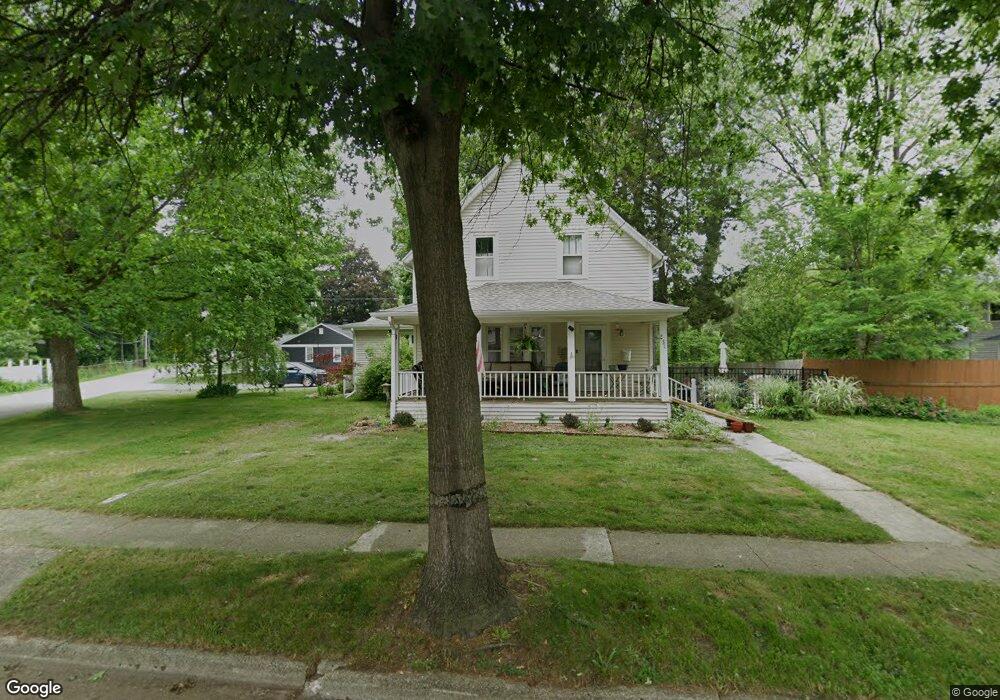
231 Gilkey St Plainwell, MI 49080
Estimated Value: $310,000 - $336,254
4
Beds
3
Baths
2,345
Sq Ft
$139/Sq Ft
Est. Value
About This Home
This home is located at 231 Gilkey St, Plainwell, MI 49080 and is currently estimated at $325,564, approximately $138 per square foot. 231 Gilkey St is a home located in Allegan County with nearby schools including Plainwell High School and Otsego Christian Academy.
Ownership History
Date
Name
Owned For
Owner Type
Purchase Details
Closed on
Oct 11, 2023
Sold by
Raich Elizabeth L
Bought by
Elizabeth L Raich Revocable Trust and Raich
Current Estimated Value
Purchase Details
Closed on
Sep 3, 2019
Sold by
Nooney James Lewis and Nooney Charlene May
Bought by
Raich Thomas L and Raich Elizabeth
Purchase Details
Closed on
Apr 30, 2015
Sold by
Nooney James Lewis and Nooney Charlene May
Bought by
Nooney James Lewis and Nooney Charlene May
Create a Home Valuation Report for This Property
The Home Valuation Report is an in-depth analysis detailing your home's value as well as a comparison with similar homes in the area
Home Values in the Area
Average Home Value in this Area
Purchase History
| Date | Buyer | Sale Price | Title Company |
|---|---|---|---|
| Elizabeth L Raich Revocable Trust | -- | None Listed On Document | |
| Raich Elizabeth L | -- | None Listed On Document | |
| Raich Thomas L | $200,000 | Servicelink | |
| Nooney James Lewis | -- | None Available |
Source: Public Records
Tax History
| Year | Tax Paid | Tax Assessment Tax Assessment Total Assessment is a certain percentage of the fair market value that is determined by local assessors to be the total taxable value of land and additions on the property. | Land | Improvement |
|---|---|---|---|---|
| 2025 | $5,586 | $162,700 | $41,400 | $121,300 |
| 2024 | $5,070 | $146,600 | $35,100 | $111,500 |
| 2023 | $5,176 | $130,100 | $32,500 | $97,600 |
| 2022 | $5,070 | $118,200 | $29,700 | $88,500 |
| 2021 | $4,868 | $108,400 | $24,700 | $83,700 |
| 2020 | $4,481 | $95,800 | $24,700 | $71,100 |
| 2019 | $2,285 | $83,400 | $23,100 | $60,300 |
| 2018 | $0 | $83,800 | $28,300 | $55,500 |
| 2017 | $0 | $71,300 | $21,900 | $49,400 |
| 2016 | $0 | $53,300 | $11,200 | $42,100 |
| 2015 | -- | $53,300 | $11,200 | $42,100 |
| 2014 | -- | $45,200 | $11,600 | $33,600 |
| 2013 | -- | $43,000 | $11,600 | $31,400 |
Source: Public Records
Map
Nearby Homes
- 551 W Bridge St
- 140 W 1st Ave
- 320 S Sunset St
- 404 Park St
- 355 12th St
- V/L Bronson Ave
- 1248 Keith St
- 1046 Bronson Ave
- 936 James St
- 721 E Bridge St
- 1224 102nd Ave
- 323 13th St
- 830 Miller Rd Unit 26.98 Acres
- 1006 Goodsell St
- 1038 Allen Ct
- 10809 N 12th St
- 909 Barton St
- 1009 Barton St
- VL 107th Ave
- V/L N 12th St
Your Personal Tour Guide
Ask me questions while you tour the home.