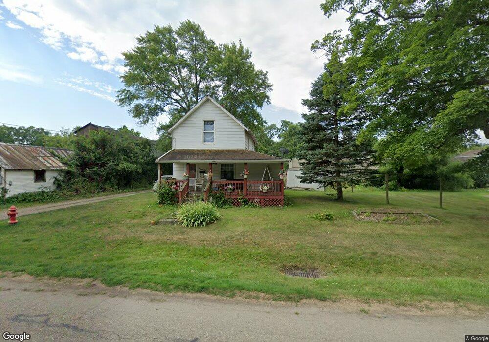
231 Keystone St Alliance, OH 44601
Estimated Value: $81,000 - $93,000
2
Beds
1
Bath
832
Sq Ft
$103/Sq Ft
Est. Value
About This Home
This home is located at 231 Keystone St, Alliance, OH 44601 and is currently estimated at $85,538, approximately $102 per square foot. 231 Keystone St is a home located in Stark County with nearby schools including Alliance Early Learning School, Alliance Intermediate School at Northside, and Alliance Middle School.
Ownership History
Date
Name
Owned For
Owner Type
Purchase Details
Closed on
Oct 31, 2019
Sold by
Barth C Andrew
Bought by
Eberling Ellis L and Eberling Emilie J
Current Estimated Value
Purchase Details
Closed on
Oct 5, 2015
Sold by
Lower Carolyn Kay
Bought by
Barth C Andrew
Purchase Details
Closed on
Jan 28, 1998
Sold by
Barnes Walter B
Bought by
Lower Carolyn K
Purchase Details
Closed on
Jun 4, 1997
Sold by
Ceresna Paul
Bought by
Barnes Walter B
Create a Home Valuation Report for This Property
The Home Valuation Report is an in-depth analysis detailing your home's value as well as a comparison with similar homes in the area
Home Values in the Area
Average Home Value in this Area
Purchase History
| Date | Buyer | Sale Price | Title Company |
|---|---|---|---|
| Eberling Ellis L | $5,000 | None Available | |
| Barth C Andrew | $5,000 | Heritage Union Title Co Ltd | |
| Lower Carolyn K | $8,000 | -- | |
| Barnes Walter B | $13,500 | -- |
Source: Public Records
Tax History Compared to Growth
Tax History
| Year | Tax Paid | Tax Assessment Tax Assessment Total Assessment is a certain percentage of the fair market value that is determined by local assessors to be the total taxable value of land and additions on the property. | Land | Improvement |
|---|---|---|---|---|
| 2025 | -- | $13,800 | $4,520 | $9,280 |
| 2024 | -- | $13,800 | $4,520 | $9,280 |
| 2023 | $0 | $4,410 | $2,590 | $1,820 |
| 2022 | $74 | $4,410 | $2,590 | $1,820 |
| 2021 | $74 | $4,410 | $2,590 | $1,820 |
| 2020 | $74 | $3,850 | $1,890 | $1,960 |
| 2019 | $74 | $3,850 | $1,890 | $1,960 |
| 2018 | $148 | $3,850 | $1,890 | $1,960 |
| 2017 | $74 | $3,260 | $1,580 | $1,680 |
| 2016 | $148 | $3,260 | $1,580 | $1,680 |
| 2015 | $149 | $3,260 | $1,580 | $1,680 |
| 2014 | $539 | $3,470 | $1,680 | $1,790 |
| 2013 | $83 | $3,470 | $1,680 | $1,790 |
Source: Public Records
Map
Nearby Homes
- 124 E Wayne St
- 710 N Freedom Ave
- 652 N Webb Ave
- 361 E Main St
- 11344 Walnut Ave NE
- 263 Franklin Ave
- 11310 Webb Ave NE
- 142 S Seneca Ave
- 163 W Market St
- 356 E Broadway St
- 511 W Ely St
- 132 S Haines Ave
- 329 1/2 W Main St
- V/L S Fredeom Ave
- 432 S Linden Ave
- 345 W Market St
- 427 S Union Ave
- 1214 Jersey St
- 15995 Elbrook St NE
- 11680 Walnut Ave NE
- 657 Walnut Ave
- 665 Walnut Ave Unit 1
- 665 Walnut Ave Unit 2
- 707 Walnut Ave
- 254 Keystone St
- 240 Keystone St
- 240 Keystone St
- 660 Walnut Ave
- 719 Walnut Ave
- 704 Walnut Ave
- 633 Walnut Ave
- 244 E Wayne St
- 270 Keystone St
- 228 E Wayne St
- 726 Garrison Ave
- 737 Walnut Ave
- 732 Walnut Ave
- 743 745 Walnut Ave Unit 4
- 743 Walnut Ave
- 743 Walnut Ave Unit 4