Estimated Value: $863,050 - $1,122,000
4
Beds
3
Baths
2,345
Sq Ft
$407/Sq Ft
Est. Value
About This Home
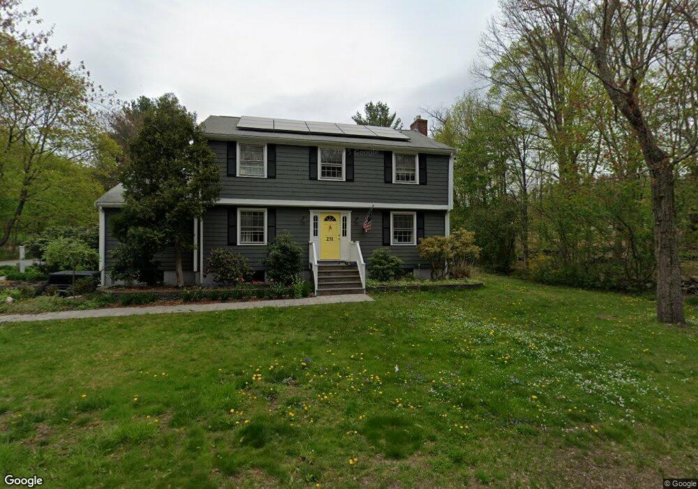
This home is located at 231 Newtown Rd, Acton, MA 01720 and is currently estimated at $953,763, approximately $406 per square foot. 231 Newtown Rd is a home located in Middlesex County with nearby schools including Acton-Boxborough Regional High School and Oak Meadow Montessori School.
Ownership History
Date
Name
Owned For
Owner Type
Purchase Details
Closed on
Jun 27, 2008
Sold by
Kastelein Daniel R and Kastelein Judy R
Bought by
Maxwell Jeffrey F and Maxwell Jill H
Current Estimated Value
Home Financials for this Owner
Home Financials are based on the most recent Mortgage that was taken out on this home.
Original Mortgage
$434,000
Outstanding Balance
$279,986
Interest Rate
6.07%
Mortgage Type
Purchase Money Mortgage
Estimated Equity
$673,777
Create a Home Valuation Report for This Property
The Home Valuation Report is an in-depth analysis detailing your home's value as well as a comparison with similar homes in the area
Home Values in the Area
Average Home Value in this Area
Purchase History
| Date | Buyer | Sale Price | Title Company |
|---|---|---|---|
| Maxwell Jeffrey F | $620,000 | -- |
Source: Public Records
Mortgage History
| Date | Status | Borrower | Loan Amount |
|---|---|---|---|
| Open | Maxwell Jeffrey F | $434,000 |
Source: Public Records
Tax History
| Year | Tax Paid | Tax Assessment Tax Assessment Total Assessment is a certain percentage of the fair market value that is determined by local assessors to be the total taxable value of land and additions on the property. | Land | Improvement |
|---|---|---|---|---|
| 2025 | $13,749 | $801,700 | $346,800 | $454,900 |
| 2024 | $12,886 | $773,000 | $346,800 | $426,200 |
| 2023 | $12,559 | $715,200 | $315,500 | $399,700 |
| 2022 | $11,905 | $612,100 | $274,300 | $337,800 |
| 2021 | $11,764 | $581,500 | $253,800 | $327,700 |
| 2020 | $11,101 | $577,000 | $253,800 | $323,200 |
| 2019 | $10,584 | $546,400 | $253,800 | $292,600 |
| 2018 | $10,411 | $537,200 | $253,800 | $283,400 |
| 2017 | $10,151 | $532,600 | $253,800 | $278,800 |
| 2016 | $9,978 | $518,900 | $253,800 | $265,100 |
| 2015 | $9,933 | $521,400 | $253,800 | $267,600 |
| 2014 | $9,637 | $495,500 | $253,800 | $241,700 |
Source: Public Records
Map
Nearby Homes
- 4 Omega Way
- 4 Littlefield Rd
- 5 Perkins Ln
- 96 Newtown Rd
- 79 Charter Rd
- 28 Springfield Dr
- 305 Harwood Ave
- 20 Joseph Reed Ln
- 35 Queen Rd
- 146 Tahattawan Rd
- 235 Arlington St
- 33 Meadowbrook Rd
- 159 Skyline Dr Unit 159
- 18 Hayward Rd
- 11 Braebrook
- 19 Ipswich Dr
- 103 Nagog Hill Rd
- 631 Massachusetts Ave Unit 631
- 18 Long Lake Rd
- 134 Russet Ln Unit 134
- 3 Country Side Rd
- 235 Newtown Rd
- 225 Newtown Rd
- 223 Newtown Rd
- 2 Countryside Rd
- 219 Newtown Rd
- 237 Newtown Rd
- 8 Countryside Rd
- 5 Countryside Rd
- 217 Newtown Rd
- 9 Countryside Rd
- 2 Bulette Rd
- 215 Newtown Rd
- 232 Newtown Rd
- 4 Bulette Rd
- 4 Bulette Rd Unit 4
- 14 Countryside Rd
- 213 Newtown Rd
- 220 Newtown Rd
- 15 Countryside Rd
Your Personal Tour Guide
Ask me questions while you tour the home.