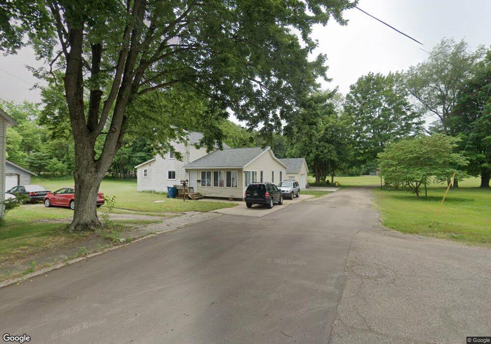
231 Roberts St Plainwell, MI 49080
Estimated Value: $168,000 - $257,000
3
Beds
2
Baths
1,752
Sq Ft
$118/Sq Ft
Est. Value
About This Home
This home is located at 231 Roberts St, Plainwell, MI 49080 and is currently estimated at $206,646, approximately $117 per square foot. 231 Roberts St is a home located in Allegan County with nearby schools including Plainwell High School and Otsego Christian Academy.
Ownership History
Date
Name
Owned For
Owner Type
Purchase Details
Closed on
Jun 21, 2016
Sold by
The Ruth M Austin Living Trust
Bought by
Dennany Michael J
Current Estimated Value
Purchase Details
Closed on
Nov 30, 2015
Sold by
Austin Ruth M and Austin Harold F
Bought by
Austin Ruth M
Purchase Details
Closed on
Apr 13, 2011
Sold by
Austin Harold F and Austin Ruth M
Bought by
Austin Harold F and Austin Ruth M
Create a Home Valuation Report for This Property
The Home Valuation Report is an in-depth analysis detailing your home's value as well as a comparison with similar homes in the area
Home Values in the Area
Average Home Value in this Area
Purchase History
| Date | Buyer | Sale Price | Title Company |
|---|---|---|---|
| Dennany Michael J | $72,000 | Devon Title Agency | |
| Austin Ruth M | -- | Attorney | |
| Austin Ruth M | -- | Attorney | |
| Austin Harold F | -- | Devon Title Agency |
Source: Public Records
Tax History
| Year | Tax Paid | Tax Assessment Tax Assessment Total Assessment is a certain percentage of the fair market value that is determined by local assessors to be the total taxable value of land and additions on the property. | Land | Improvement |
|---|---|---|---|---|
| 2025 | $2,461 | $85,300 | $20,700 | $64,600 |
| 2024 | $2,223 | $78,000 | $15,300 | $62,700 |
| 2023 | $2,241 | $72,500 | $15,300 | $57,200 |
| 2022 | $2,223 | $59,900 | $11,100 | $48,800 |
| 2021 | $2,136 | $56,800 | $10,800 | $46,000 |
| 2020 | $1,730 | $43,700 | $7,500 | $36,200 |
| 2019 | $1,571 | $43,500 | $7,500 | $36,000 |
| 2018 | $0 | $38,400 | $7,500 | $30,900 |
| 2017 | $0 | $34,100 | $3,900 | $30,200 |
| 2016 | $0 | $30,100 | $8,700 | $21,400 |
| 2015 | -- | $30,100 | $8,700 | $21,400 |
| 2014 | -- | $27,500 | $8,700 | $18,800 |
| 2013 | -- | $26,200 | $8,700 | $17,500 |
Source: Public Records
Map
Nearby Homes
- 721 E Bridge St
- 936 James St
- 317 E Chart St
- 404 Park St
- 233 Washington Ave
- 140 W 1st Ave
- 426 W Bridge St
- 830 Miller Rd Unit 26.98 Acres
- V/L Bronson Ave
- 770 Miller Rd
- 1046 Bronson Ave
- 551 W Bridge St
- 1170 W Bridge St
- 355 12th St
- 1036 Sir Knight Rd
- 575 Rushing Dr
- 1224 102nd Ave
- 10809 N 12th St
- 1248 Keith St
- 1038 Allen Ct
- 223 Roberts St
- 217 Roberts St
- 220 Roberts St
- 212 Roberts St
- 203 Roberts St
- 130 Forbes St
- 220 Roberts
- 150 Orchard St
- 129 Forbes St
- 202 Roberts St
- 136 Orchard St
- 119 Forbes St
- 130 Orchard St
- 122 Orchard St
- 325 S Sherwood Ave
- 325 S Sherwood Ave Unit 3
- 325 S Sherwood Ave
- 325 S Sherwood Ave Unit 2
- 311 S Sherwood Ave
- 303 S Sherwood Ave
Your Personal Tour Guide
Ask me questions while you tour the home.