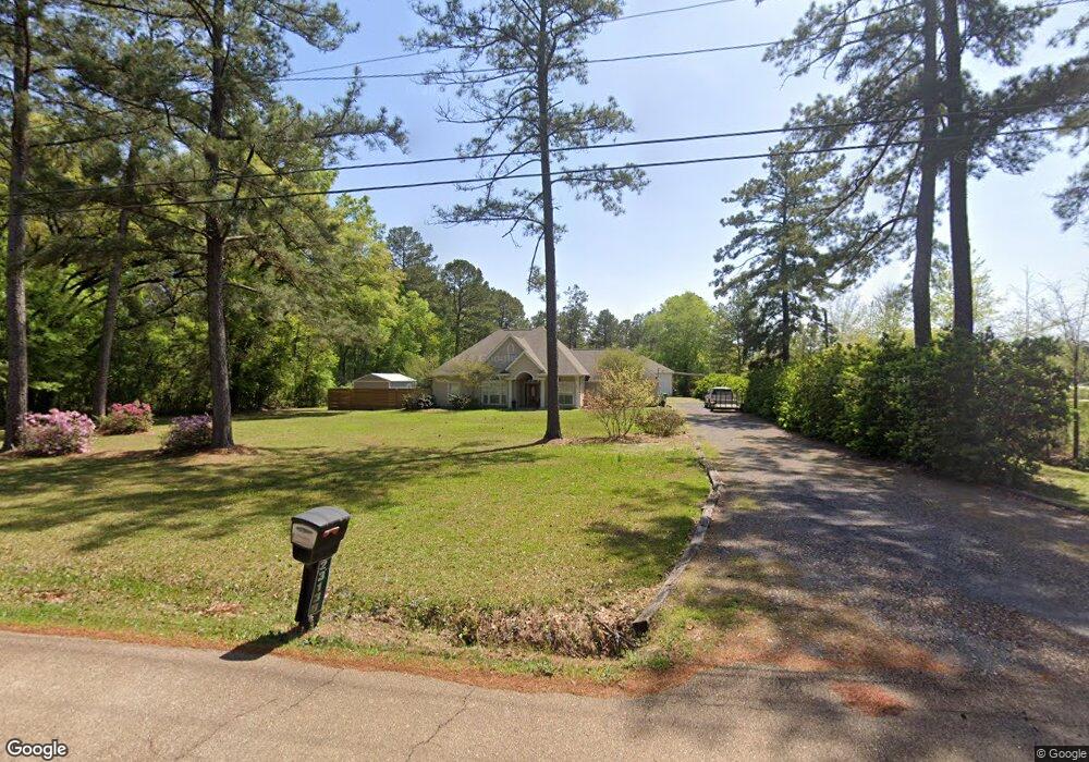
23138 Wittie Ln Robert, LA 70455
Estimated Value: $242,000 - $467,000
3
Beds
2
Baths
2,000
Sq Ft
$179/Sq Ft
Est. Value
About This Home
This home is located at 23138 Wittie Ln, Robert, LA 70455 and is currently estimated at $358,564, approximately $179 per square foot. 23138 Wittie Ln is a home located in Tangipahoa Parish with nearby schools including Hammond Eastside Magnet and Hammond High Magnet School.
Ownership History
Date
Name
Owned For
Owner Type
Purchase Details
Closed on
Aug 1, 2006
Sold by
Brownlow Anthony Joseph and Brownlow Tonya Searcy
Bought by
Gegenheimer Stewart Michael and Gegenheimer Theresa Heidal
Current Estimated Value
Home Financials for this Owner
Home Financials are based on the most recent Mortgage that was taken out on this home.
Original Mortgage
$237,600
Outstanding Balance
$141,875
Interest Rate
6.66%
Mortgage Type
New Conventional
Estimated Equity
$216,689
Create a Home Valuation Report for This Property
The Home Valuation Report is an in-depth analysis detailing your home's value as well as a comparison with similar homes in the area
Home Values in the Area
Average Home Value in this Area
Purchase History
| Date | Buyer | Sale Price | Title Company |
|---|---|---|---|
| Gegenheimer Stewart Michael | $297,000 | None Available |
Source: Public Records
Mortgage History
| Date | Status | Borrower | Loan Amount |
|---|---|---|---|
| Open | Gegenheimer Stewart Michael | $237,600 |
Source: Public Records
Tax History Compared to Growth
Tax History
| Year | Tax Paid | Tax Assessment Tax Assessment Total Assessment is a certain percentage of the fair market value that is determined by local assessors to be the total taxable value of land and additions on the property. | Land | Improvement |
|---|---|---|---|---|
| 2024 | $2,668 | $27,701 | $3,847 | $23,854 |
| 2023 | $2,662 | $27,415 | $3,562 | $23,853 |
| 2022 | $2,662 | $27,415 | $3,562 | $23,853 |
| 2021 | $1,939 | $27,415 | $3,562 | $23,853 |
| 2020 | $2,661 | $27,415 | $3,562 | $23,853 |
| 2019 | $2,654 | $27,415 | $3,562 | $23,853 |
| 2018 | $2,662 | $27,415 | $3,562 | $23,853 |
| 2017 | $2,662 | $27,415 | $3,562 | $23,853 |
| 2016 | $2,662 | $27,415 | $3,562 | $23,853 |
| 2015 | $2,036 | $28,452 | $3,562 | $24,890 |
| 2014 | $1,910 | $28,452 | $3,562 | $24,890 |
Source: Public Records
Map
Nearby Homes
- 23205 Audubon Lakes Blvd
- AUDUBON-AH18 Plan at Audubon Trace
- AUDUBON-AH44 Plan at Audubon Trace
- AUDUBON-AH40 Plan at Audubon Trace
- AUDUBON-AH62 Plan at Audubon Trace
- AUDUBON-AH39 Plan at Audubon Trace
- AUDUBON-AH65 Plan at Audubon Trace
- AUDUBON-AH59 Plan at Audubon Trace
- AUDUBON-AH61 Plan at Audubon Trace
- 47013 Rivergate Dr
- 23187 Audubon Lakes Blvd
- 0 Hwy 445 & Wittie Unit 2507340
- 0 Hwy 445 & Wittie Other Unit 2507340
- 45075 Chemekette Rd
- 47693 Cathy Ln
- 47595 Cathy Ln
- 47649 Cathy Ln
- 47527 Hutton Cove
- 45505 Coleman Rd
- 48177 Savannahwood Dr
- 47019 Willow Dr
- 0 Wittie Ln
- 46496 Purple Finch Point Rd
- 46496 Purple Finch Point
- 46484 Purple Finch Point Rd
- 47020 Willow Dr
- 46479 Purple Finch Point
- 46483 Purple Finch Point
- 46479 Purple Finch Point Rd
- 46495 Purple Finch Point Rd
- 23333 Pecan Grove Dr
- 23130 Mallards Row
- 23091 Audubon Lakes Blvd
- 3 Willow Dr
- 1 Willow Dr
- 5 Willow Dr
- 0 Willow Dr
- 47053 Willow Dr
- 23120 Mallards Row
- 23080 Audubon Lakes Blvd