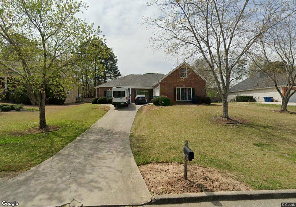
2315 Amberbrook Ln Unit 1 Grayson, GA 30017
Estimated Value: $414,472 - $459,000
3
Beds
3
Baths
2,454
Sq Ft
$180/Sq Ft
Est. Value
About This Home
This home is located at 2315 Amberbrook Ln Unit 1, Grayson, GA 30017 and is currently estimated at $440,868, approximately $179 per square foot. 2315 Amberbrook Ln Unit 1 is a home located in Gwinnett County with nearby schools including Grayson Elementary School, Bay Creek Middle School, and Grayson High School.
Ownership History
Date
Name
Owned For
Owner Type
Purchase Details
Closed on
Jan 30, 2004
Sold by
Amberbrook Lane Land Trust
Bought by
Sterling Bruce and Sterling Deirdre
Current Estimated Value
Home Financials for this Owner
Home Financials are based on the most recent Mortgage that was taken out on this home.
Original Mortgage
$4,573
Interest Rate
5.77%
Purchase Details
Closed on
Jun 8, 2001
Sold by
Willis Charles W and Willis Christine R
Bought by
Amberbrook Lane Land Trust
Purchase Details
Closed on
Jul 15, 1999
Sold by
Harrington Homes Inc
Bought by
Willis Charles W and Willis Christine R
Home Financials for this Owner
Home Financials are based on the most recent Mortgage that was taken out on this home.
Original Mortgage
$151,900
Interest Rate
7.38%
Mortgage Type
New Conventional
Create a Home Valuation Report for This Property
The Home Valuation Report is an in-depth analysis detailing your home's value as well as a comparison with similar homes in the area
Home Values in the Area
Average Home Value in this Area
Purchase History
| Date | Buyer | Sale Price | Title Company |
|---|---|---|---|
| Sterling Bruce | $224,000 | -- | |
| Amberbrook Lane Land Trust | -- | -- | |
| Willis Charles W | $159,000 | -- |
Source: Public Records
Mortgage History
| Date | Status | Borrower | Loan Amount |
|---|---|---|---|
| Closed | Sterling Bruce | $4,573 | |
| Open | Sterling Bruce | $197,000 | |
| Previous Owner | Willis Charles W | $151,900 |
Source: Public Records
Tax History
| Year | Tax Paid | Tax Assessment Tax Assessment Total Assessment is a certain percentage of the fair market value that is determined by local assessors to be the total taxable value of land and additions on the property. | Land | Improvement |
|---|---|---|---|---|
| 2025 | $4,768 | $167,720 | $36,000 | $131,720 |
| 2024 | $4,582 | $151,840 | $36,000 | $115,840 |
| 2023 | $4,582 | $166,600 | $36,000 | $130,600 |
| 2022 | $4,238 | $136,880 | $30,400 | $106,480 |
| 2021 | $3,785 | $112,400 | $24,000 | $88,400 |
| 2020 | $3,810 | $112,400 | $24,000 | $88,400 |
| 2019 | $3,521 | $104,080 | $24,000 | $80,080 |
| 2018 | $3,448 | $100,520 | $20,800 | $79,720 |
| 2016 | $3,063 | $82,080 | $20,800 | $61,280 |
| 2015 | $2,704 | $71,120 | $11,000 | $60,120 |
| 2014 | -- | $71,120 | $11,000 | $60,120 |
Source: Public Records
Map
Nearby Homes
- 2265 Amberbrook Ln Unit 1
- 240 Clark Lake Ln
- 390 Herring Rd
- 2341 Herring Woods Trail
- 466 Middleton Place Unit 2
- 2408 Camellia Allee Ct
- 205 Amberbrook Cir Unit 2
- 178 Mission Oak Dr
- 89 Mission Oak Dr
- 131 Patricia Terrace
- 128 Graybrook Ct
- 520 Herring Rd
- 2249 Cluster Ln
- 2597 Misty Rose Ln
- 2474 Starfire Ln Unit 2
- 2607 Misty Rose Ln
- 2391 Loganville Hwy
- 644 Herring Rd
- 2584 Loganville Hwy
- 1518 High Falls Ln
- 2305 Amberbrook Ln
- 2325 Amberbrook Ln
- 2335 Amberbrook Ln Unit 1
- 2300 Whetstone Dr
- 171 Brownsmill Dr
- 2290 Whetstone Dr
- 2310 Amberbrook Ln
- 2330 Amberbrook Ln Unit 1
- 2320 Amberbrook Ln
- 2285 Amberbrook Ln
- 2290 Amberbrook Ln
- 2345 Amberbrook Ln Unit 1
- 161 Brownsmill Dr
- 0 Whetstone Dr Unit 7169096
- 2280 Whetstone Dr
- 65 Tollwood Place
- 2355 Amberbrook Ln
- 2275 Amberbrook Ln Unit 1
- 150 Brownsmill Dr
- 2377 Tollwood Ct
Your Personal Tour Guide
Ask me questions while you tour the home.