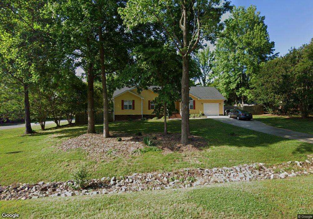
2317 Brasswynd Ct Fuquay Varina, NC 27526
Estimated Value: $345,000 - $394,000
3
Beds
3
Baths
1,537
Sq Ft
$243/Sq Ft
Est. Value
About This Home
This home is located at 2317 Brasswynd Ct, Fuquay Varina, NC 27526 and is currently estimated at $373,648, approximately $243 per square foot. 2317 Brasswynd Ct is a home located in Wake County with nearby schools including Banks Road Elementary School and West Lake Middle.
Ownership History
Date
Name
Owned For
Owner Type
Purchase Details
Closed on
May 22, 2019
Sold by
Hooks Dennis R and Hooks Lisa E
Bought by
Stacy Steven Harold and Brophy Anna Jane
Current Estimated Value
Home Financials for this Owner
Home Financials are based on the most recent Mortgage that was taken out on this home.
Original Mortgage
$255,000
Outstanding Balance
$223,741
Interest Rate
4.1%
Mortgage Type
New Conventional
Estimated Equity
$149,907
Purchase Details
Closed on
Jun 27, 2016
Sold by
Whitlock Tabitha
Bought by
Hooks Dennis R and Hooks Lisa E
Home Financials for this Owner
Home Financials are based on the most recent Mortgage that was taken out on this home.
Original Mortgage
$215,000
Interest Rate
2.81%
Mortgage Type
VA
Purchase Details
Closed on
Sep 29, 2015
Sold by
Whitlock Ryan and Whitlock Tabitha
Bought by
Whitlock Tabitha
Purchase Details
Closed on
Apr 30, 2014
Sold by
Howell Charlote K
Bought by
Whitlock Ryan and Whitlock Tabitha
Home Financials for this Owner
Home Financials are based on the most recent Mortgage that was taken out on this home.
Original Mortgage
$105,000
Interest Rate
4.37%
Mortgage Type
Adjustable Rate Mortgage/ARM
Purchase Details
Closed on
Jul 28, 2004
Sold by
Burke Paul D and Burke Susan J
Bought by
Howell Charlotte K
Home Financials for this Owner
Home Financials are based on the most recent Mortgage that was taken out on this home.
Original Mortgage
$111,520
Interest Rate
6.75%
Mortgage Type
New Conventional
Purchase Details
Closed on
Nov 9, 1998
Sold by
Johnson William E and Johnson Rebecca C
Bought by
Burke Paul D and Burke Susan J
Home Financials for this Owner
Home Financials are based on the most recent Mortgage that was taken out on this home.
Original Mortgage
$107,600
Interest Rate
10.25%
Purchase Details
Closed on
May 5, 1998
Sold by
Fish Brothers Developers
Bought by
Johnson William E and Johnson Rebecca C
Create a Home Valuation Report for This Property
The Home Valuation Report is an in-depth analysis detailing your home's value as well as a comparison with similar homes in the area
Home Values in the Area
Average Home Value in this Area
Purchase History
| Date | Buyer | Sale Price | Title Company |
|---|---|---|---|
| Stacy Steven Harold | $255,000 | None Available | |
| Hooks Dennis R | $215,000 | None Available | |
| Whitlock Tabitha | -- | Attorney | |
| Whitlock Ryan | $105,000 | None Available | |
| Howell Charlotte K | $139,500 | -- | |
| Burke Paul D | $134,500 | -- | |
| Johnson William E | $49,000 | Commonwealth Land Title Ins |
Source: Public Records
Mortgage History
| Date | Status | Borrower | Loan Amount |
|---|---|---|---|
| Open | Stacy Steven Harold | $255,000 | |
| Previous Owner | Hooks Dennis R | $215,000 | |
| Previous Owner | Whitlock Ryan | $105,000 | |
| Previous Owner | Howell Charlotte K | $111,520 | |
| Previous Owner | Burke Paul D | $107,600 | |
| Closed | Howell Charlotte K | $27,880 |
Source: Public Records
Tax History Compared to Growth
Tax History
| Year | Tax Paid | Tax Assessment Tax Assessment Total Assessment is a certain percentage of the fair market value that is determined by local assessors to be the total taxable value of land and additions on the property. | Land | Improvement |
|---|---|---|---|---|
| 2025 | $2,443 | $378,878 | $90,000 | $288,878 |
| 2024 | $2,373 | $378,878 | $90,000 | $288,878 |
| 2023 | $2,007 | $254,795 | $45,000 | $209,795 |
| 2022 | $1,860 | $254,795 | $45,000 | $209,795 |
| 2021 | $1,810 | $254,795 | $45,000 | $209,795 |
| 2020 | $1,781 | $254,795 | $45,000 | $209,795 |
| 2019 | $1,373 | $165,691 | $38,000 | $127,691 |
| 2018 | $1,263 | $165,691 | $38,000 | $127,691 |
| 2017 | $1,198 | $165,691 | $38,000 | $127,691 |
| 2016 | $1,174 | $165,691 | $38,000 | $127,691 |
| 2015 | $1,159 | $163,991 | $35,000 | $128,991 |
| 2014 | $1,099 | $163,991 | $35,000 | $128,991 |
Source: Public Records
Map
Nearby Homes
- 1601 Malcus Ct Unit 65
- 3324 Air Park Rd
- 2417 Ridgeford Ct
- 1401 Malcus Ct Unit 58
- 4225 Hilltop Needmore Rd
- 4229 Hilltop Needmore Rd
- 4700 Linaria Ln
- 4313 Darius Ln
- 1504 Malcus Ct Unit 52
- 4313 Darius Ln Unit 25
- 4400 Emeline Way Unit 36
- 4301 Emeline Way Unit 15
- 4412 Darius Ln Unit 39
- Macon Plan at Rowland's Grant
- Knox Plan at Rowland's Grant
- Leland Plan at Rowland's Grant
- Jordan Plan at Rowland's Grant
- Camden Plan at Rowland's Grant
- Finley Plan at Rowland's Grant
- Alexis Plan at Rowland's Grant
- 2321 Brasswynd Ct
- 2316 Buckstone Ct
- 2313 Brasswynd Ct
- 2316 Brasswynd Ct
- 2320 Buckstone Ct
- 2325 Brasswynd Ct
- 2309 Brasswynd Ct
- 2324 Brasswynd Ct
- 2308 Buckstone Ct
- 2300 Buckstone Ct
- 2324 Buckstone Ct
- 2329 Brasswynd Ct
- 2313 Buckstone Ct
- 2317 Buckstone Ct
- 2328 Brasswynd Ct
- 2328 Buckstone Ct
- 2309 Buckstone Ct
- 2321 Buckstone Ct
- 2301 Buckstone Ct
- 3720 Air Park Rd