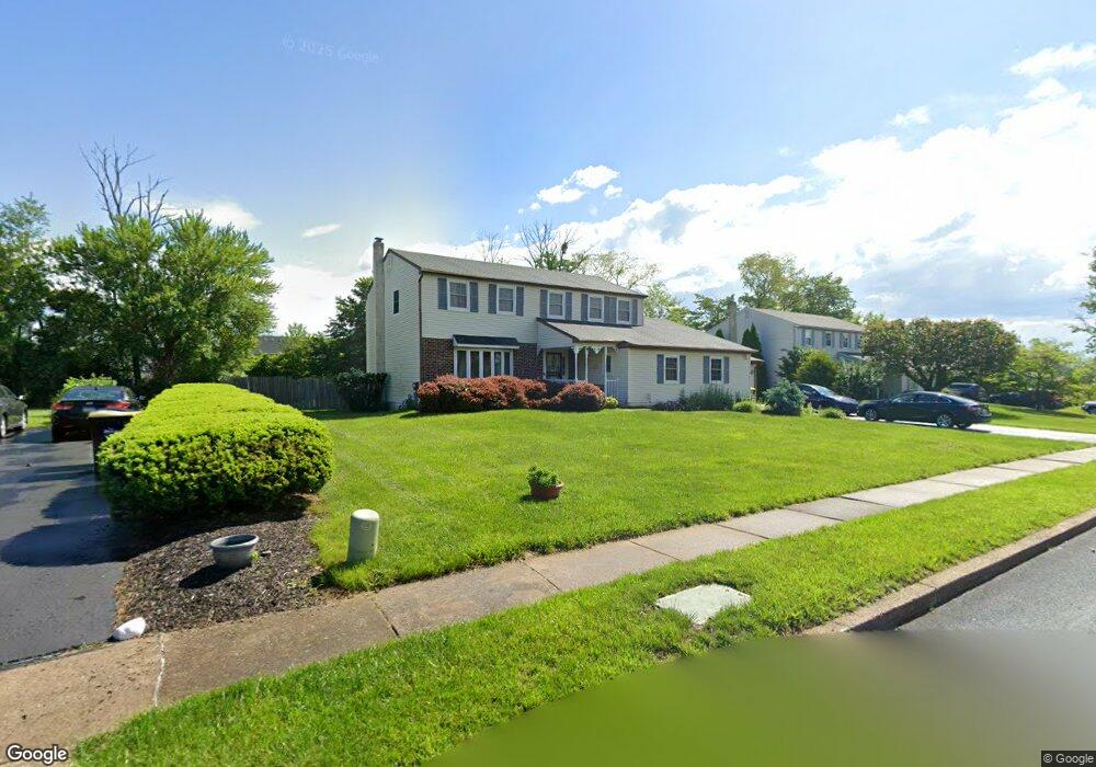
2319 Carol Ln Norristown, PA 19401
Estimated Value: $556,000 - $645,175
4
Beds
4
Baths
2,728
Sq Ft
$221/Sq Ft
Est. Value
About This Home
This home is located at 2319 Carol Ln, Norristown, PA 19401 and is currently estimated at $604,044, approximately $221 per square foot. 2319 Carol Ln is a home located in Montgomery County with nearby schools including Cole Manor Elementary School, East Norriton Middle School, and Charles Blockson Middle School.
Ownership History
Date
Name
Owned For
Owner Type
Purchase Details
Closed on
Mar 25, 2011
Sold by
Lavong Joyce and Lavong April Lynda
Bought by
Lavong April Lynda
Current Estimated Value
Home Financials for this Owner
Home Financials are based on the most recent Mortgage that was taken out on this home.
Original Mortgage
$209,600
Outstanding Balance
$145,365
Interest Rate
4.99%
Estimated Equity
$458,679
Create a Home Valuation Report for This Property
The Home Valuation Report is an in-depth analysis detailing your home's value as well as a comparison with similar homes in the area
Home Values in the Area
Average Home Value in this Area
Purchase History
| Date | Buyer | Sale Price | Title Company |
|---|---|---|---|
| Lavong April Lynda | -- | None Available |
Source: Public Records
Mortgage History
| Date | Status | Borrower | Loan Amount |
|---|---|---|---|
| Open | Lavong April Lynda | $209,600 |
Source: Public Records
Tax History Compared to Growth
Tax History
| Year | Tax Paid | Tax Assessment Tax Assessment Total Assessment is a certain percentage of the fair market value that is determined by local assessors to be the total taxable value of land and additions on the property. | Land | Improvement |
|---|---|---|---|---|
| 2025 | $9,615 | $204,080 | $62,840 | $141,240 |
| 2024 | $9,615 | $204,080 | $62,840 | $141,240 |
| 2023 | $9,503 | $204,080 | $62,840 | $141,240 |
| 2022 | $9,437 | $204,080 | $62,840 | $141,240 |
| 2021 | $9,378 | $204,080 | $62,840 | $141,240 |
| 2020 | $9,087 | $204,080 | $62,840 | $141,240 |
| 2019 | $8,876 | $204,080 | $62,840 | $141,240 |
| 2018 | $8,877 | $204,080 | $62,840 | $141,240 |
| 2017 | $8,360 | $204,080 | $62,840 | $141,240 |
| 2016 | $8,281 | $204,080 | $62,840 | $141,240 |
| 2015 | $7,847 | $204,080 | $62,840 | $141,240 |
| 2014 | $7,847 | $204,080 | $62,840 | $141,240 |
Source: Public Records
Map
Nearby Homes
- 72 Brownstone Dr
- 29 Penn Crossing Dr
- 7 Merri Claude Dr
- 0 Central St
- 2413 Sentry Ct
- 2300 Sienna Dr
- 2405 Romano Ct
- 204 Millcreek Rd
- 212 Valley Rd
- 2461 Merri Claude Dr
- 22 Laurel Ln
- 9 Crimson Dr
- 111 Lafayette Rd
- 1326 Germantown Pike
- 108 Lawnton Rd
- 51 Zummo Way Unit CONDO
- 107 Hancock Ave
- 41 Zummo Way
- 4 Zummo Way
- 182 Bradbury Dr