T
Seller's Agent in 2025
Team DOMUS
Domus Ave Realty

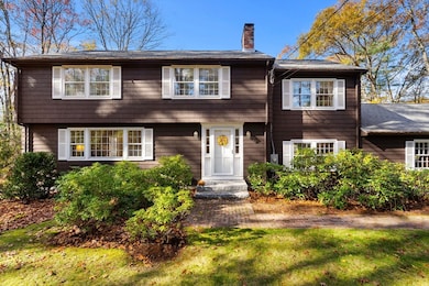
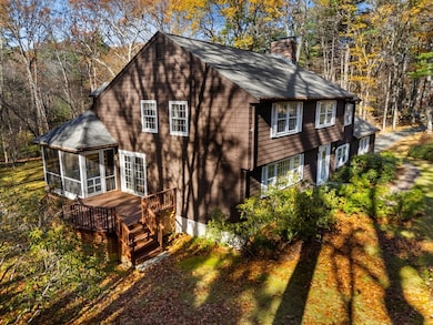
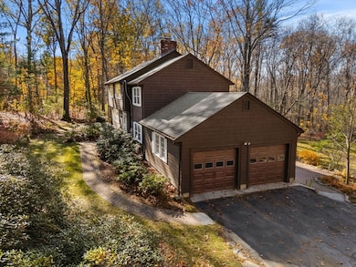
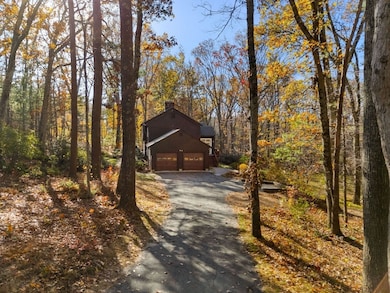
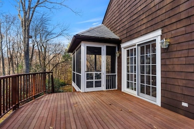
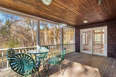
Welcome home! Close to Carlisle center and situated on over 2 wooded acres, this meticulously cared-for Colonial is a rare find. Boasting 4 bedrooms and 2.5 baths, the home has been expanded from its original footprint with a light-filled kitchen addition featuring two stories of windows with a vaulted ceiling, sure to please any cook! Entertain in your formal dining room or warm up in the cozy den with a wood-burning fireplace. Work from home from the lower-level office overlooking the serene backyard. The inviting screened porch, beautiful wood decks, and private backyard with direct trail access to Estabrook Woods offer year-round enjoyment for all! Proximity to Malcolm Preserve conservation area further enhances the opportunity to enjoy the beautiful surroundings and tranquility of this charming setting. New S
Last Agent to Sell the Property
Team DOMUS
Domus Ave Realty Listed on: 11/05/2025
| Date | Type | Sale Price | Title Company |
|---|---|---|---|
| Quit Claim Deed | $1,200,000 | -- | |
| Quit Claim Deed | -- | None Available | |
| Deed | $340,000 | -- |
| Date | Status | Loan Amount | Loan Type |
|---|---|---|---|
| Open | $675,000 | New Conventional | |
| Previous Owner | $198,000 | No Value Available | |
| Previous Owner | $203,000 | No Value Available | |
| Previous Owner | $178,500 | No Value Available | |
| Previous Owner | $150,000 | Purchase Money Mortgage |
| Date | Event | Price | List to Sale | Price per Sq Ft |
|---|---|---|---|---|
| 12/18/2025 12/18/25 | Sold | $1,200,000 | -4.0% | $398 / Sq Ft |
| 11/12/2025 11/12/25 | Pending | -- | -- | -- |
| 11/05/2025 11/05/25 | For Sale | $1,250,000 | -- | $415 / Sq Ft |
| Year | Tax Paid | Tax Assessment Tax Assessment Total Assessment is a certain percentage of the fair market value that is determined by local assessors to be the total taxable value of land and additions on the property. | Land | Improvement |
|---|---|---|---|---|
| 2025 | $12,099 | $918,000 | $547,500 | $370,500 |
| 2024 | $11,852 | $889,100 | $503,900 | $385,200 |
| 2023 | $11,490 | $812,000 | $502,900 | $309,100 |
| 2022 | $11,392 | $690,400 | $414,900 | $275,500 |
| 2021 | $11,240 | $690,400 | $414,900 | $275,500 |
| 2020 | $11,282 | $614,500 | $327,800 | $286,700 |
| 2019 | $11,097 | $606,700 | $327,800 | $278,900 |
| 2018 | $4,274 | $606,700 | $327,800 | $278,900 |
| 2017 | $4,287 | $600,800 | $327,800 | $273,000 |
| 2016 | $10,334 | $600,800 | $327,800 | $273,000 |
| 2015 | $10,228 | $538,300 | $314,700 | $223,600 |
| 2014 | $10,034 | $538,300 | $314,700 | $223,600 |
T
Seller's Agent in 2025
Team DOMUS
Domus Ave Realty

Seller Co-Listing Agent in 2025
Massimo Taurisano
Domus Ave Realty
(339) 221-1916
1 in this area
15 Total Sales
G
Seller Co-Listing Agent in 2025
Gina Stark
Domus Ave Realty
1 in this area
3 Total Sales
Buyer's Agent in 2025
Zachary Friedman
Compass
(617) 877-0582
2 in this area
34 Total Sales
Source: MLS Property Information Network (MLS PIN)
MLS Number: 73451441
APN: CARL-000009-000056-000001
Disclaimer: Certain information contained herein is derived from information provided by parties other than Homes.com. All information provided is deemed reliable, but is not guaranteed to be accurate and should be independently verified.
![]() The property listing data and information, or the Images, set forth herein were provided to MLS Property Information Network, Inc. from third party sources, including sellers, lessors and public records, and were compiled by MLS Property Information Network, Inc. The property listing data and information, and the Images, are for the personal, non-commercial use of consumers having a good faith interest in purchasing or leasing listed properties of the type displayed to them and may not be used for any purpose other than to identify prospective properties which such consumers may have a good faith interest in purchasing or leasing. MLS Property Information Network, Inc. and its subscribers disclaim any and all representations and warranties as to the accuracy of the property listing data and information, or as to the accuracy of any of the Images, set forth herein.
The property listing data and information, or the Images, set forth herein were provided to MLS Property Information Network, Inc. from third party sources, including sellers, lessors and public records, and were compiled by MLS Property Information Network, Inc. The property listing data and information, and the Images, are for the personal, non-commercial use of consumers having a good faith interest in purchasing or leasing listed properties of the type displayed to them and may not be used for any purpose other than to identify prospective properties which such consumers may have a good faith interest in purchasing or leasing. MLS Property Information Network, Inc. and its subscribers disclaim any and all representations and warranties as to the accuracy of the property listing data and information, or as to the accuracy of any of the Images, set forth herein.
Ask me questions while you tour the home.