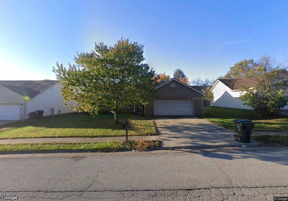
232 Colony Blvd Unit 5 Georgetown, KY 40324
Estimated Value: $230,000 - $277,000
3
Beds
2
Baths
1,405
Sq Ft
$183/Sq Ft
Est. Value
About This Home
This home is located at 232 Colony Blvd Unit 5, Georgetown, KY 40324 and is currently estimated at $256,940, approximately $182 per square foot. 232 Colony Blvd Unit 5 is a home located in Scott County with nearby schools including Anne Mason Elementary School, Creekside Elementary School, and Scott County Middle School.
Ownership History
Date
Name
Owned For
Owner Type
Purchase Details
Closed on
Mar 24, 2023
Sold by
Boldt John R
Bought by
Roe Andrew and Roe Kourtney
Current Estimated Value
Purchase Details
Closed on
Nov 22, 2019
Sold by
Patton John E D and Patton Shanna M
Bought by
Boldt John R
Purchase Details
Closed on
Jun 30, 2011
Sold by
Tiller Lawrence R and Tiller Anne J
Bought by
Boldt John R
Home Financials for this Owner
Home Financials are based on the most recent Mortgage that was taken out on this home.
Original Mortgage
$131,445
Interest Rate
4.62%
Mortgage Type
New Conventional
Create a Home Valuation Report for This Property
The Home Valuation Report is an in-depth analysis detailing your home's value as well as a comparison with similar homes in the area
Home Values in the Area
Average Home Value in this Area
Purchase History
| Date | Buyer | Sale Price | Title Company |
|---|---|---|---|
| Roe Andrew | $125,000 | Bluegrass Land Title | |
| Boldt John R | $103,000 | None Available | |
| Boldt John R | $127,000 | Capstone Title Services |
Source: Public Records
Mortgage History
| Date | Status | Borrower | Loan Amount |
|---|---|---|---|
| Previous Owner | Boldt John R | $131,445 |
Source: Public Records
Tax History Compared to Growth
Tax History
| Year | Tax Paid | Tax Assessment Tax Assessment Total Assessment is a certain percentage of the fair market value that is determined by local assessors to be the total taxable value of land and additions on the property. | Land | Improvement |
|---|---|---|---|---|
| 2024 | $2,021 | $224,700 | $0 | $0 |
| 2023 | $1,909 | $210,500 | $38,500 | $172,000 |
| 2022 | $1,514 | $178,100 | $33,000 | $145,100 |
| 2021 | $1,557 | $165,300 | $33,000 | $132,300 |
| 2020 | $1,299 | $151,200 | $33,000 | $118,200 |
| 2019 | $1,260 | $144,400 | $0 | $0 |
| 2018 | $1,162 | $133,880 | $0 | $0 |
| 2017 | $1,167 | $133,880 | $0 | $0 |
| 2016 | $1,050 | $130,344 | $0 | $0 |
| 2015 | $1,016 | $127,000 | $0 | $0 |
| 2014 | $1,053 | $127,000 | $0 | $0 |
| 2011 | $79 | $127,512 | $0 | $0 |
Source: Public Records
Map
Nearby Homes
- 106 Plymouth Ct
- 129 Cornwallis Dr
- 245 Sturbridge Dr
- 134 S Bold Forbes Blvd
- 145 Inverness Dr
- 177 Swilcan Bridge Way
- 103 War Admiral Way
- 194 Shinnecock Hill Dr
- 141 Shinnecock Hill Dr
- 98 Delissa Dr
- 210 Taylorsville Trail
- 442 General John Payne Blvd
- 83 Falls Creek Dr
- 109 Blackberry Ln
- 116 Falls Creek Dr
- 110 Blackberry Ln
- 100 Woods Point Cir
- 113 Blackberry Ln
- 118 Falls Creek Dr
- 123 Blackberry Ln
- 234 Colony Blvd
- 230 Colony Blvd
- 108 Bain Bridge Dr
- 108 Bainbridge Dr
- 110 Bain Bridge Dr
- 106 Bain Bridge Dr Unit 6
- 236 Colony Blvd
- 106 Bainbridge Dr
- 110 Bainbridge Dr
- 233 Colony Blvd
- 112 Bain Bridge Dr Unit 6
- 231 Colony Blvd
- 104 Bainbridge Dr
- 104 Bain Bridge Dr Unit 6
- 235 Colony Blvd
- 112 Bainbridge Dr
- 0 Bainbridge Dr
- 238 Colony Blvd
- 226 Colony Blvd
- 229 Colony Blvd