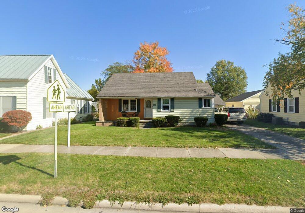
232 N Main St Minster, OH 45865
Estimated Value: $224,000 - $301,000
2
Beds
1
Bath
1,439
Sq Ft
$182/Sq Ft
Est. Value
About This Home
This home is located at 232 N Main St, Minster, OH 45865 and is currently estimated at $261,925, approximately $182 per square foot. 232 N Main St is a home located in Auglaize County with nearby schools including Minster Elementary School and Minster Junior/Senior High School.
Ownership History
Date
Name
Owned For
Owner Type
Purchase Details
Closed on
Jul 18, 2022
Sold by
Bryan Him
Bought by
Hirn Elizabeth
Current Estimated Value
Purchase Details
Closed on
Dec 14, 2015
Sold by
Cummins Kirby C and Cummins Cindy
Bought by
Hirn Bryan and Hirn Elizabeth
Home Financials for this Owner
Home Financials are based on the most recent Mortgage that was taken out on this home.
Original Mortgage
$133,536
Interest Rate
4.25%
Mortgage Type
FHA
Purchase Details
Closed on
Apr 28, 2011
Sold by
Roetgerman Patricia M and Monnin Mary Jo
Bought by
Cummins Ii Kirby C and Cummins Cindy
Home Financials for this Owner
Home Financials are based on the most recent Mortgage that was taken out on this home.
Original Mortgage
$64,000
Interest Rate
4.77%
Mortgage Type
New Conventional
Purchase Details
Closed on
Jul 3, 1996
Bought by
Burchett Waldo W
Create a Home Valuation Report for This Property
The Home Valuation Report is an in-depth analysis detailing your home's value as well as a comparison with similar homes in the area
Home Values in the Area
Average Home Value in this Area
Purchase History
| Date | Buyer | Sale Price | Title Company |
|---|---|---|---|
| Hirn Elizabeth | -- | None Listed On Document | |
| Hirn Bryan | $136,000 | Republic Title Agency Inc | |
| Cummins Ii Kirby C | $80,000 | Attorney | |
| Burchett Waldo W | -- | -- |
Source: Public Records
Mortgage History
| Date | Status | Borrower | Loan Amount |
|---|---|---|---|
| Previous Owner | Hirn Bryan | $133,536 | |
| Previous Owner | Cummins Ii Kirby C | $64,000 |
Source: Public Records
Tax History
| Year | Tax Paid | Tax Assessment Tax Assessment Total Assessment is a certain percentage of the fair market value that is determined by local assessors to be the total taxable value of land and additions on the property. | Land | Improvement |
|---|---|---|---|---|
| 2025 | $3,619 | $52,090 | $15,740 | $36,350 |
| 2024 | $3,619 | $52,090 | $15,740 | $36,350 |
| 2023 | $1,772 | $52,090 | $15,740 | $36,350 |
| 2022 | $1,682 | $45,740 | $14,440 | $31,300 |
| 2021 | $1,711 | $45,740 | $14,440 | $31,300 |
| 2020 | $883 | $45,746 | $14,445 | $31,301 |
| 2019 | $1,538 | $37,524 | $11,872 | $25,652 |
| 2018 | $1,538 | $37,524 | $11,872 | $25,652 |
| 2017 | $1,427 | $37,524 | $11,872 | $25,652 |
| 2016 | $1,324 | $33,982 | $10,770 | $23,212 |
| 2015 | $1,301 | $33,982 | $10,770 | $23,212 |
| 2014 | $1,303 | $33,982 | $10,770 | $23,212 |
| 2013 | $1,366 | $33,982 | $10,770 | $23,212 |
Source: Public Records
Map
Nearby Homes
- 31 Melcher St
- 17 Stonegate Dr
- 0 Stonegate Dr Unit 14 10544847
- 0 Stonegate Dr Unit 21 10544857
- 36 Shania Place Unit 23
- 28 Shania Place Unit 33
- 19 Shania Place Unit 33
- 27 Shania Place Unit 26
- 7 E 2nd St
- 561 S Walnut St Unit Lot3
- 315 Mid Lane St
- 5761 Fisher & Koverman Rd
- 1991 Minster Egypt Pike
- 130 Janice Dr
- 410 E Cherry St
- 137 Janice Dr
- 217 S Washington St
- 39 Harlamert Dr
- 132 Janice Dr
- 141 Janice Dr
Your Personal Tour Guide
Ask me questions while you tour the home.